
11:15 AM (Sunday) | *****Long duration major winter storm for the Mid-Atlantic....could turn out to be one of the all-time greats for some parts of eastern PA, upstate NJ and southeastern NY*****
Paul Dorian

As the coastal storm intensifies on Monday, there will be a strong jet in the lower part of the atmosphere extending all the way from south-central PA to the coast. This lower atmosphere jet streak should translate to strong winds at ground level during the height of the storm and it’ll feed plenty of Atlantic Ocean moisture into a cold air mass over the northern Mid-Atlantic. Map courtesy NOAA, tropicaltidbits.com
Overview
A major and complex storm system is coming to the Mid-Atlantic region and it will be a long duration event with impact into Tuesday. Indeed, this storm could turn out to be one of the all-time greats for some sections of eastern PA, upstate New Jersey, and southeastern New York. The storm will come in two phases with the first part already underway and associated with a process known as “overrunning”. The second phase of this major winter storm event will feature a very slow moving and powerful storm just off the Mid-Atlantic coastline.

A blocking pattern in the upper atmosphere over eastern Canada will play a big role in the major winter storm for the Mid-Atlantic region. A coastal storm will become the dominant player by early Monday and it will continue to impact the Mid-Atlantic region well into Tuesday as it grinds to a halt off the coastline. Map courtesy NOAA, tropicaltidbits.com
Details
“Phase 1” of our major winter storm has begun and it is resulting in an outburst of “overrunning” type snow across Virginia, Maryland and the DC metro region. “Overrunning” is a process in which warmer air from the southwest is forced to ride up and over dense, cold Arctic air that is in place in the Mid-Atlantic region. This warmer air is being pushed to the northeast by low pressure that is moving into the Ohio Valley from the central Plains. This location in the Ohio Valley will turn out to be the most northward extent of this primary low pressure system and where it begins its demise later today as upper-level support transfers to the east coast.

Phase 1 of the major winter storm has already begun and it is featuring “overrunning” type snowfall which occurs when warmer air is forced up and over dense, cold Arctic air that will be in place in the Mid-Atlantic region. An initial or “primary” low pressure system is moving over the Ohio Valley and it will stall out here and begin to weaken as its upper-level support diminishes. A secondary storm system will then develop by later tonight near the Carolina coastline and this will become the main player. Map courtesy Canadian Meteorological Centre, Pivotal Weather
“Phase 2” will take place from later tonight into at least later Tuesday as a storm system develops near the Carolina coastline and becomes the dominant player while the primary low now over the Ohio Valley fades away. This coastal storm will develop as upper-level energy swings around the base of a larger-scale trough and produces strong upward motion near the Carolina coastline. There is also a natural temperature gradient in this particular area between the warm waters of the nearby Gulf Stream in the western Atlantic Ocean and the cold air that will be situated over the nearby land mass. This sharp temperature gradient combined with upper-level energy will contribute to storm formation right near the Carolina coastline - an area known for the genesis of many east coast storms.

Phase 2 of the upcoming major winter storm will take place from late tonight into Tuesday as a coastal (secondary) storm becomes the dominant player. The heaviest snow in eastern PA, upstate NJ and southeastern NY will take place during this second stage and winds will pick up noticeably - perhaps prompting “blizzard warnings” to be issued for some spots. Colder air from the north will get wrapped into the system by later Monday and those places that change to a mixture of precipitation on Sunday night or early Monday are likely to change back to all snow by later Monday and the snow will continue on Monday night and Tuesday. Map courtesy Canadian Meteorological Centre, tropicaltidbits.com
As this system intensifies and moves north/northeast, it will come increasingly under the influence of a strong blocking pattern in the atmosphere over the eastern part of Canada. This is an important factor in the development of east coast snowstorms as is strong high pressure ridging across the western US which will indeed be in place. The developing storm will ultimately grind to a halt just off the Mid-Atlantic coastline and it could even “retrograde” or take a loop back towards the east coast during the early part of the week – all of which will result in a long duration event with impact lasting well into Tuesday for much of the Mid-Atlantic region.

“Mesoscale” banding is possible during phase 2 of the major winter storm as there will be plenty of upper-level energy to support such activity. These “mesoscale” bands can contain bursts of intense snowfall and perhaps even some rumbles of thunder. The most likely time for this would be during the height of the coastal storm later Monday into Tuesday and the most probable places would include eastern PA, upstate New Jersey and southeastern NY. Map courtesy NOAA, Weather Bell Analytics
As the coastal storm intensifies, the pressure gradient surrounding it will tighten and winds will increase markedly later Monday and Monday night; especially, across eastern Pennsylvania, New Jersey, and southeastern New York. Another key point here is that once the coastal storm stalls out over the western Atlantic Ocean, it will pull in some very cold air from the north/northeast. Those areas that change from snow to a mixture of precipitation later tonight or early Monday will likely change back to all snow later Monday and there will be additional accumulations with this “wrap around” snow all the way down to the DC metro region. In fact, the intrusion of cold air on the back side of the coastal storm will result in significant accumulating snow all the way down to the coastal sections of New Jersey and the Delmarva Peninsula. “Blizzard warnings” may need to be issued for this storm system by NOAA’s National Weather Service due to the potential combination of heavy snow and strong winds with the most probable regions to include at least parts of eastern Pennsylvania, upstate New Jersey, and southeastern New York.

A compilation of snowfall estimates from the ensemble runs of the European model (upper left), GFS (upper right) and the Canadian model (lower left) show the general consensus idea of the heaviest snowfall taking place from eastern PA to upstate NJ to southeastern NY.
Here is a breakdown by metro region in the Mid-Atlantic’s I-95 corridor as to what to expect during this long duration major winter storm:
DC metro region:
Snow will continue at varying rates today in the DC metro region during this “overrunning” (first) phase of the winter storm with 3-6 inches possible by early tonight. The precipitation will become mixed by early tonight and spotty, mixed precipitation can continue into tomorrow morning. Any mixed precipitation on Monday morning will then likely change back to all snow by mid-day as colder air wraps around from the north/northeast during the second phase of the storm with the intensifying storm just off the Mid-Atlantic coastline. The “wrap around” snow will continue into early Tuesday associated with the off-shore storm system and some additional accumulations are likely.
Total snowfall estimates for the DC metro region by the end of the storm on late Tuesday: 6-10 inches.
Philly, NYC metro regions
There can be a snow shower or two this morning in the Philly metro region, but the steadier snow will arrive during the mid-day or early afternoon hours and it can be mixed with sleet at times. The snow should reach the NYC metro area by the mid-to-late afternoon hours. Snow will continue tonight at varying rates and it can be mixed with sleet at times; especially, to the south and east of Route I-95. Any mixed precipitation tomorrow morning should change back to all snow by later in the day as colder air wraps around the intensifying storm system off the Mid-Atlantic coastline.
The brunt of this winter storm for the Philly and NYC metro regions will come later tomorrow and tomorrow night. The snow will become heavy at times from later tomorrow into tomorrow night and there can be significant accumulations. Given the very strong dynamics in the upper atmosphere, there is the potential for “mesoscale” or small-scale banding during the height of this storm containing brief outbursts of very heavy snowfall and even possible rumbles of thunder. In addition, the winds will increase markedly later Monday resulting in some blowing and drifting of the snow and those strong winds will actually continue right into the middle of the week.
Total snowfall estimates:
Philly and NYC metro regions by the end of the storm on late Tuesday: 12-18 inches with isolated higher amounts
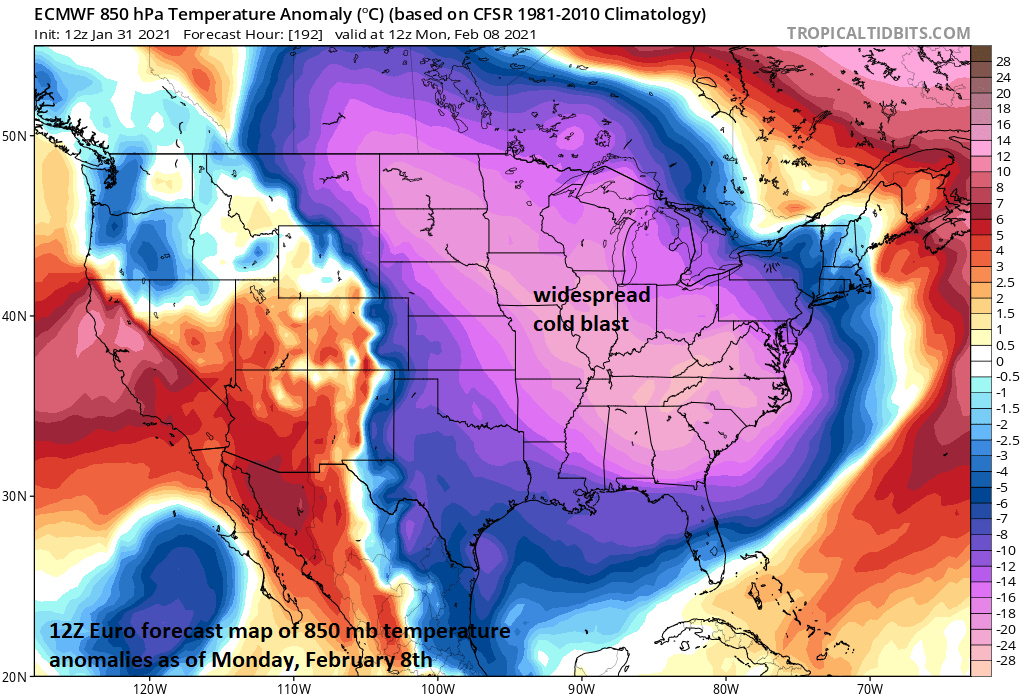
Widespread cold for the second week of February as depicted here by the 12Z Euro model run. Map courtesy ECMWF, tropicaltidbits.com
Looking ahead
It never hurts to look ahead and indeed there is some very interesting weather likely coming to much of the central and eastern US. It appears increasingly likely that there will be some very cold air around by the second week of February and this cold wave may very well include some additional snow threats for the Mid-Atlantic. One such threat could come in about a week’s time during the latter part of next weekend and a second could follow several days later.
Stay tuned for further updates on the current major winter storm as it is quite complex and also for word on longer-term possibilities.
Meteorologist Paul Dorian
Perspecta, Inc.
perspectaweather.com