11:50 AM | *Stratospheric warming, teleconnection trends, high-latitude blocking – all pointing to a colder and stormy weather pattern for much of January in the eastern US*
Paul Dorian

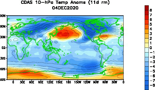
Stratospheric warming has taken place over the last 30 days in the high latitudes as indicated by this loop of temperature anomalies at the 10 millibar level (warmer-than-normal temperatures indicated by yellow, orange). Maps courtesy NOAA
Overview
The overall weather pattern has been quite active in recent days in the eastern US with two different storm systems impacting the area in just the last three days. Numerous signs in the atmosphere point to a continuation of the stormy weather pattern in coming weeks across the eastern US and it is likely to become increasingly colder - raising the chances for accumulating snow. An on-going stratospheric warming event raises the prospects for high-latitude blocking in coming weeks which, in turn, increases the chance for increasingly colder outbreaks into the Mid-Atlantic/NE US. Teleconnection trends in such indices as the North Atlantic Oscillation (NAO) support the notion for a sustained period of high-latitude blocking which, in turn, would be more favorable for coastal storm development. In the near-term, one storm will likely push to the Carolina coastline on Friday and it may then stay to the south and east of the DC-to-Philly-to-NYC corridor as it heads out-to-sea - but it still needs to be closely monitored. Another winter storm is likely to threaten the southern and eastern US during the early or middle parts of next week as the active pattern continues.

An on-going stratospheric warming event has resulted in the “breaking apart” of the polar vortex into two vortices with abnormal warming today right over the North Pole (actual temperatures shown at left, temperature anomalies shown at right). Map courtesy WSI, Inc (Twitter: MJVentrice), NOAA
Stratospheric warming and high-latitude blocking
One way to monitor the potential for wintertime Arctic air outbreaks into the eastern U.S. is to track the temperature pattern in the stratosphere over the polar region of the Northern Hemisphere. The stratosphere is the second major layer of the atmosphere just above the troposphere and below the mesosphere. It occupies the region of atmosphere from about 12 to 50 km, although its lower boundary tends to be higher nearer the equator and lower nearer the poles. The stratosphere defines a layer in which temperatures rise with increasing altitude. At the top of the stratosphere, the thin air may attain temperatures close to 0°C. This rise in temperature is caused by the absorption of ultraviolet (UV) radiation from the sun by the ozone layer. Such a temperature profile creates very stable atmospheric conditions and the stratosphere lacks the air turbulence that is so prevalent in the troposphere. Consequently, the stratosphere is almost completely free of clouds or other forms of weather.

Another way to view the “splitting” of the polar vortex on January 4th is by looking at this 3-D diagram of potential temperature centered over the polar region. The “sister” vortices are seen here in a 3-D fashion with one piece much larger than the other. Plot courtesy WSI, Inc. (Twitter: MJVentrice), Z.D. Lawrence (NMT) at stratobserve.com, NOAA
Sudden stratospheric warmings (SSWs) are among the most impressive dynamical events in the physical climate system. During the winter months in the polar stratosphere, temperatures are typically at or below minus 70°C. The cold temperatures are combined with strong westerly winds that form the southern boundary of the stratospheric polar vortex which plays a major role in determining how much Arctic air spills southward toward the mid-latitudes. This dominant structure is sometimes disrupted in some winters by being displaced, split apart or even reversed. Under these circumstances, the winds can decrease or change directions and the temperatures in the lower stratosphere can rise by more than 50°C in just a few days.
In response to the stratospheric warming (and associated layer expansion) at the high latitudes, the troposphere cools down dramatically (with layer contraction) at the high latitudes and pressure rises. This tropospheric cold air can then be more easily transported from the high latitudes to the middle latitudes given the "high-latitude blocking" that often sets up over places like Greenland and northeastern Canada. The entire process from the initial warming of the stratospheric at high latitudes to the cooling in the troposphere at middle latitudes can take several weeks to unfold. It is still too early to say exactly where this on-going stratospheric warming event may result in increasingly cold conditions, but if past history is any guide, it very well could be in the central and eastern US later this month. In fact, there are SSW events in recent history in which the increasingly colder air initially finds its way into Europe and Asia and then shortly thereafter, into Canada and the US. [For more information on the stratospheric warming phenomenon and high-latitude blocking visit our “Meteorology 101” page for extended video discussions on each topic).

The teleconnection index known as the North Atlantic Oscillation (NAO) is currently and should remain in “negative” territory for the foreseeable future. Plot courtesy NOAA
North Atlantic Oscillation (NAO) teleconnection index
The North Atlantic Oscillation (NAO) is measured by an index of pressure differences between the North Atlantic Ocean (Icelandic Low) and the middle latitudes (Azores High). This teleconnection index is a “closely related cousin” to the Arctic Oscillation (AO) index which focuses on pressure anomalies in the Arctic region. When the pressures in the high latitudes are higher and the air is heavier, cold air that is critical for snow, tends to pour into the Mid-Atlantic region and Northeast US. In addition to its critical role as a cold air source, sustained periods of high-latitude blocking will typically result in higher chances for coastal storms in the Mid-Atlantic/NE US. With the influx of cold air, a natural temperature gradient forms along the east coast between the cold air over land and the relatively warm air over the waters of the western Atlantic Ocean. This temperature gradient often becomes a focus area for storm development/intensification during the winter season; especially, from the Carolina coastline to northern New England.
The NAO is a critical teleconnection index to monitor during the winter season with respect to the forecasting of winter storms in the Mid-Atlantic/NE US. The word “oscillation” in its official designation as “North Atlantic Oscillation” is really a misnomer in that it doesn’t fluctuate in any predictable manner, but can actually change quite rapidly. It is not similar to the “El Nino/Southern Oscillation (ENSO)” in the tropical Pacific Ocean which is based on sea surface temperature patterns and tend to change much more slowly than the atmospheric-based pattern which dictates the changes in the NAO. As a result, the NAO is difficult to forecast beyond several days and it is influenced from the “top down”. In other words, the NAO is affected by the stratosphere and this is a part of the atmosphere where we do not have all that much in the way of data. The tropospheric response to the SSWs closely resembles the negative phase of the North Atlantic Oscillation (NAO), involving an equatorward shift of the North Atlantic storm track; extreme cold air outbreaks in parts of North America, northern Eurasia and Siberia; and strong warming of Greenland, eastern Canada, and southern Eurasia (Thompson et al., 2002).

This is still in the “speculation” phase being many days away, but the 12Z GFS on Monday features a winter storm in the Mid-Atlantic region in about a week’s time on Monday, January 11. Map courtesy NOAA, tropicaltidbits.com
Late week Carolina storm may head out-to-sea…second and more impressive threat next week
The active weather pattern of recent days will continue for the foreseeable future. A cold front crosses the Mid-Atlantic region on Tuesday afternoon and high pressure will take control of the weather on Wednesday and Thursday. The end of the week will feature a low pressure system headed to the Carolina coastline and from there it may move in a northeastward direction and head on out-to-sea. It is, however, a bit too early to write this system off for the I-95 corridor as just a little shift in the storm track could result in an impact in places like DC and Philadelphia. By the way, if this late week system does indeed turn up the coast, there is no guarantee that it would produce all snow in the I-95 corridor as there will again be only “borderline” cold in the region. Another low pressure system is likely to impact the southern and eastern US by the early part of next week, but it is too early to say how much impact it may have on the DC-to-Philly-to-NYC corridor. This particular system will need to be closely monitored closely right through the upcoming weekend.
Meteorologist Paul Dorian
Perspecta, Inc.
perspectaweather.com
Follow us on Facebook, Twitter, YouTube
Video discussion: