1:55 PM (Wednesday) | *Increasingly cold pattern to set up for the second half of January in the Mid-Atlantic/NE US…active pattern to continue as well*
Paul Dorian

12Z GFS 850 mb temperature anomalies in the 10-16 day time period (16 Jan- 22 Jan) features numerous cold air outbreaks into the eastern half of the nation. Maps courtesy NOAA, tropicaltidbits.com
Overview
While there certainly has been some moderate cold in the Mid-Atlantic/NE US in the first part of the month, the overall weather pattern that is unfolding will likely result in much colder air relative-to-normal for the second half of the month of January. The upper part of the atmosphere will evolve into a pattern that features high-latitude blocking across Greenland/northeastern Canada and high pressure ridging across the west coasts of Canada and the US. This combination will allow for the transport of increasingly cold air masses into the Mid-Atlantic/NE US as we progress through January. In addition, numerous waves of energy aloft will ensure the active pattern continues as well with many storm threats to come in coming days for much of the nation.

By the middle of the month, high-latitude blocking will form over Greenland/northeastern Canada and high pressure ridging will intensify across the western parts of Canada and the US. This type of pattern should allow for the transport of some very cold air into the eastern half of the nation during the second half of January. Map courtesy NOAA, tropicaltidbits.com
Colder pattern to set up for Mid-Atlantic/NE US
Over the next week or so, upper-level high pressure ridging will intensify in two parts of North America that will likely lead to an influx of very cold air into the Mid-Atlantic/NE US during the second half of January. Specifically, high-latitude blocking will develop with intensifying high pressure over Greenland and northeastern Canada in coming days as well as across the western parts of Canada and the US. The flow of air around the western Canadian and US ridges of high pressure will not only allow for the transport of air from northern Canada into the US, but it may also allow for a “cross-polar” flow that could bring Siberian air across the North Pole and into North America later this month.

Colder-than-normal weather is confined to the southern US over the next 5-day period with warmer-than-normal conditions across much of Canada. Map courtesy NOAA, tropicaltidbits.com
There has been some extreme cold in recent days across portions of Asia and Europe and some of this air could make its way across the pole in a modified form - if upper-air wind patterns are appropriate. Examples of the extreme cold in just the last couple of days include the following:
1) -3°F in Beijing, China (lowest temperature recorded in Beijing since February 1966)
2) 1°F in Wakayanagi, Japan (lowest temperature ever recorded in Wakayanagi)
3) -32°F was recorded in Spain earlier this morning (lowest temperature ever recorded in Spain, still an unofficial reading)

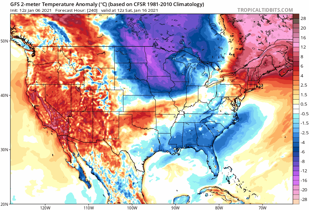
Colder-than-normal weather pattern will likely set up later this month in much of the eastern half of the nation. Map courtesy NOAA, tropicaltidbits.com
Energetic pattern to continue
In terms of storm threats, the active weather pattern experienced in recent weeks across much of the nation will likely continue through January. Multiple waves of upper-level energy across North America will result in multiple storm threats as we progress through the month, but the exact impact area for these systems will have to be addressed one at a time. The end of this week will feature a low pressure system headed to the Carolinas from the northern Gulf of Mexico and it could end up producing accumulating in the Tennessee Valley including such areas as eastern Tennessee and western North Carolina. This system is likely to stay to the south and east of the I-95 corridor in the Mid-Atlantic as it heads northeast on a track to the western Atlantic. Another system will pull out of the southeastern US early next week and take a turn to the northeast and towards the Mid-Atlantic region. Precipitation could arrive in the Mid-Atlantic region later Tuesday from this system, but many details will have to be ironed out in coming days regarding impact zone and precipitation-type. Other storms will threaten the southern and eastern US later this month as the overall pattern turns progressively colder.
Meteorologist Paul Dorian
Perspecta, Inc.
perspectaweather.com
Follow us on Facebook, Twitter, YouTube