12:30 PM (Thursday) | *Colder pattern continues to unfold for the second half of January with “cross-polar” flow…southern Appalachians snow on Friday...threat early next week in Mid-Atlantic/NE US*
Paul Dorian

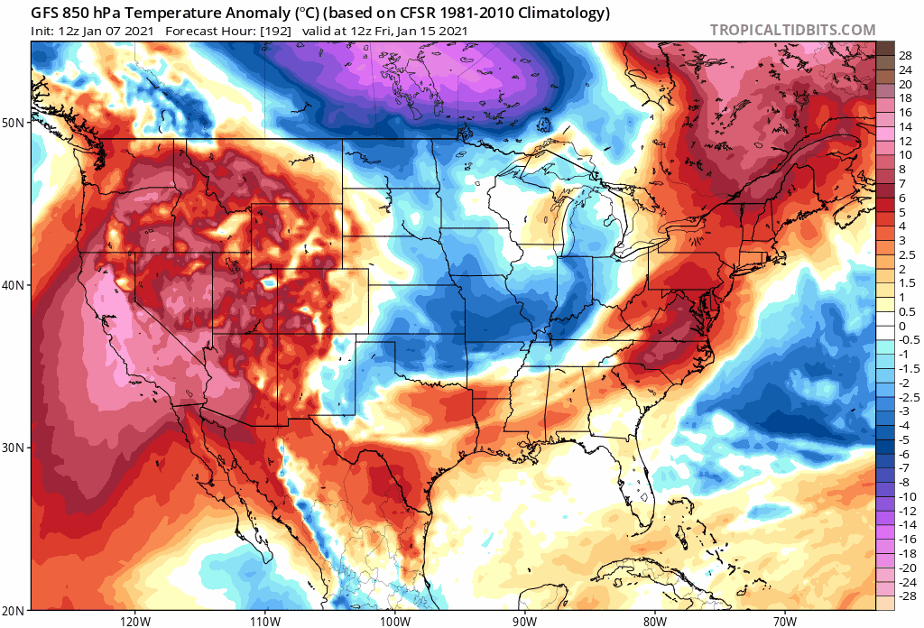
12Z GFS 850 mb temperature anomalies in the period from 15 January to 23 January which features numerous cold air outbreaks into the eastern half of the nation. Maps courtesy NOAA, tropicaltidbits.com
Overview
Changes to the overall upper-level pattern across North America during the next week or so will result in much colder air for the second half of the month of January in the Mid-Atlantic/NE US. The upper part of the atmosphere will evolve into a pattern that features high-latitude blocking across Greenland/northeastern Canada, high pressure ridging across the west coasts of Canada and the US, and even “cross-polar” flow which could transport Siberian air to this side of the North Pole. In addition, numerous waves of energy aloft will ensure the recent active weather pattern continues with numerous storm threats in coming days for much of the nation. One storm system will bring accumulating snow on Friday to the southern Appalachians from northeastern Georgia to southwestern Virginia and another system next week could threaten the Mid-Atlantic/NE US with snow and/or rain.

The upper air pattern by mid-month will feature high-latitude blocking over Greenland/northeastern Canada, strong ridging over western Canada and the western US, and possible “cross-polar” flow near the North Pole which could bring Siberian air to North America. Map courtesy NOAA, tropicaltidbits.com
Colder pattern to set up for Mid-Atlantic/NE US
Over the next week or so, upper-level high pressure ridging will intensify in two parts of North America that will lead to an influx of very cold air into the Mid-Atlantic/NE US during the second half of January. In particular, high-latitude blocking will develop with intensifying high pressure over Greenland and northeastern Canada as well as across the western parts of Canada and the US. The flow of air around the western Canada and US high pressure ridges will not only allow for the transport of air from northern Canada into the US, but it may also produce a “cross-polar” flow that could bring Siberian air (in a modified form) across the North Pole and into North America later this month. There has been some extreme cold in recent days across portions of East Asia and Europe with a few examples listed below:
1) -3°F in Beijing, China (lowest temperature recorded in Beijing since February 1966)
2) +1°F in Wakayanagi, Japan (lowest temperature ever recorded in Wakayanagi)
3) -29°F was recorded in Spain earlier this morning (lowest temperature ever recorded in Spain and now some substantial snowfall is headed their way)
Energetic pattern to continue
In terms of storm threats, the active weather pattern experienced in recent weeks across much of the nation will likely continue right through January. Multiple waves of upper-level energy across North America - in both the northern and southern branches of the jet stream - will result in multiple storm threats as we progress through the month. Each one of these systems will have to be addressed individually with respect to their potential impact zones and the ultimate interaction between the northern and southern branch waves of energy will dictate final storm track and intensity.
This week will close out with a low pressure system headed to the Carolinas from the northern Gulf of Mexico and it will produce accumulating snow in the southern Appalachians from northeastern Georgia to southwestern Virginia including such towns as Boone and Asheville in North Carolina). The precipitation shield from this system is quite likely going to stay to the south and east of the Mid-Atlantic’s I-95 corridor as it stays on a northeasterly track and moves to the western Atlantic Ocean.

Next week’s storm threat will feature waves of energy in both the northern and southern branch of the jet stream. The interaction between these two will largely determine ultimate storm track and intensity. Map courtesy NOAA, tropicaltidbits.com
Another low pressure system will bring accumulating snow to Texas by the latter part of the weekend – a deep southern state that has had its share of accumulating snow in recent days. By early next week, this system will pull out of the southeastern US and take a turn to the northeast and towards the Mid-Atlantic coastline. This low pressure area has the potential to bring accumulating snow and/or rain to the Mid-Atlantic/NE US in the Tuesday/Tuesday night time frame, but many details will have to be ironed out in coming days regarding the interaction between the upper-level waves of energy in the northern and southern branches of the jet stream. Other storms will no doubt threaten the eastern half of the nation as we progress through the month of January as the overall weather pattern turns progressively colder.
Meteorologist Paul Dorian
Perspecta, Inc.
perspectaweather.com
Follow us on Facebook, Twitter, YouTube
Video discussion: