11:45 AM | *Very powerful storm to impact the west coast from Sunday into Monday…same system can result in a mid-week severe weather outbreak and a strong east coast storm by late next week*
Paul Dorian
A powerful ocean storm will have a big impact from Sunday into Monday in the region from British Columbia (Canada) to California. Map courtesy ECMWF (00Z Euro), tropicaltidbits.com
Overview
One strong storm system has impacted the west coast states from Washington-to-California in the past 24 hours or so with significant rainfall, but an even stronger storm is likely have an impact from Sunday into Monday. In fact, this next storm could become the strongest system in many years to impact the region from British Columbia (Canada) to California. Rainfall will be excessive with this next storm, winds will be powerful and potentially damaging, and snow will pile up in the higher elevations of the Sierra Nevada Mountains in eastern California. The upper-level support for this system is likely to then cross the country next week and that could result in a mid-week severe weather outbreak and a late week storm near the eastern seaboard.
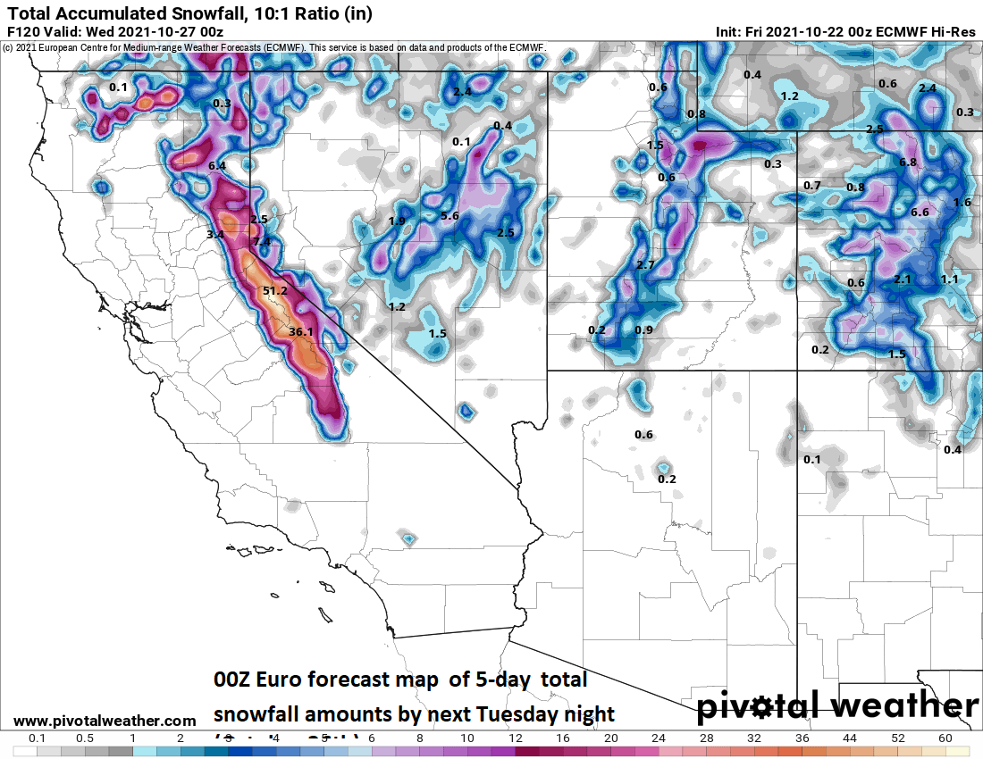
Significant snow on the order of several feet is on the table from this upcoming storm across the higher elevations of the Sierra Nevada Mountains in eastern California. Map courtesy ECMWF (00Z Euro), pivotalweather.com
Details
Rain is falling today across many of the western states from California to Washington, but this is just the opening salvo in an overall weather pattern that will bring excessive rainfall to this same region from Sunday into Monday. After a break in the action from later tonight into Saturday, more rain will develop along the west coast on Sunday as a powerful storm system pushes towards British Columbia/Pacific Northwest. Some computer forecast models have projected central pressure of this developing storm system to bottom out near 940 millibars (27.76 inches) in coming days which would be some of the deepest readings seen in decades that close to the Pacific Northwest coastline.
Much of the western US has been experiencing “extreme” or “exceptional” drought conditions in recent weeks, but that is likely to change in a big way in coming days. Map courtesy NOAA/CPC
Some of the heaviest rainfall from this monster storm system is likely to take place across the northern half of California from Sunday into Monday where several inches can fall and localized flash flooding is a serious concern. Snow can pile up in this same time frame on the order of several feet across the higher elevation locations of the Sierra Nevada Mountain in eastern California. Strong and potentially damaging winds are likely to accompany this storm as well; especially, along the west coast of Washington which will be near the storm system when it reaches its lowest pressure. A couple of benefits from the expected rainfall will the filling of some of the lakes across the western states (e.g., Lake Shasta is ~25% full) and it would also stop any still on-going wildfire activity in its tracks; however, these will benefits may come at a steep price.
The upper-level support associated with the powerful late weekend storm will cross the country next week and take on a “negative-tilt” by the time it reaches the Mississippi Valley. This scenario could result in a mid-week severe weather outbreak including possible tornadoes across the Mississippi/Tennessee Valleys and Upper Midwest. Map courtesy ECMWF (00Z Euro), tropicaltidbits.com
After slamming the west coast, this system will push into the Rocky Mountain States early next week with some rain and snow and then the upper-level support will push into the nation’s mid-section at mid-week and begin taking on a “negative tilt” (i.e., trough axis aloft becomes oriented from NW-to-SE). With such strong support aloft, a severe weather outbreak is on the table at mid-week including the threat of tornadoes in the Deep South. By late next week, the upper-level support associated with this powerful storm system will arrive in the eastern states and it could very well spawn a strong surface storm along the eastern seaboard…stay tuned.


