3:00 PM (Monday) | *****Major winter storm continues to have a significant impact on the northern Mid-Atlantic region...strong winds and heavy snowfall across much of eastern PA, NJ and SE NY*****
Paul Dorian

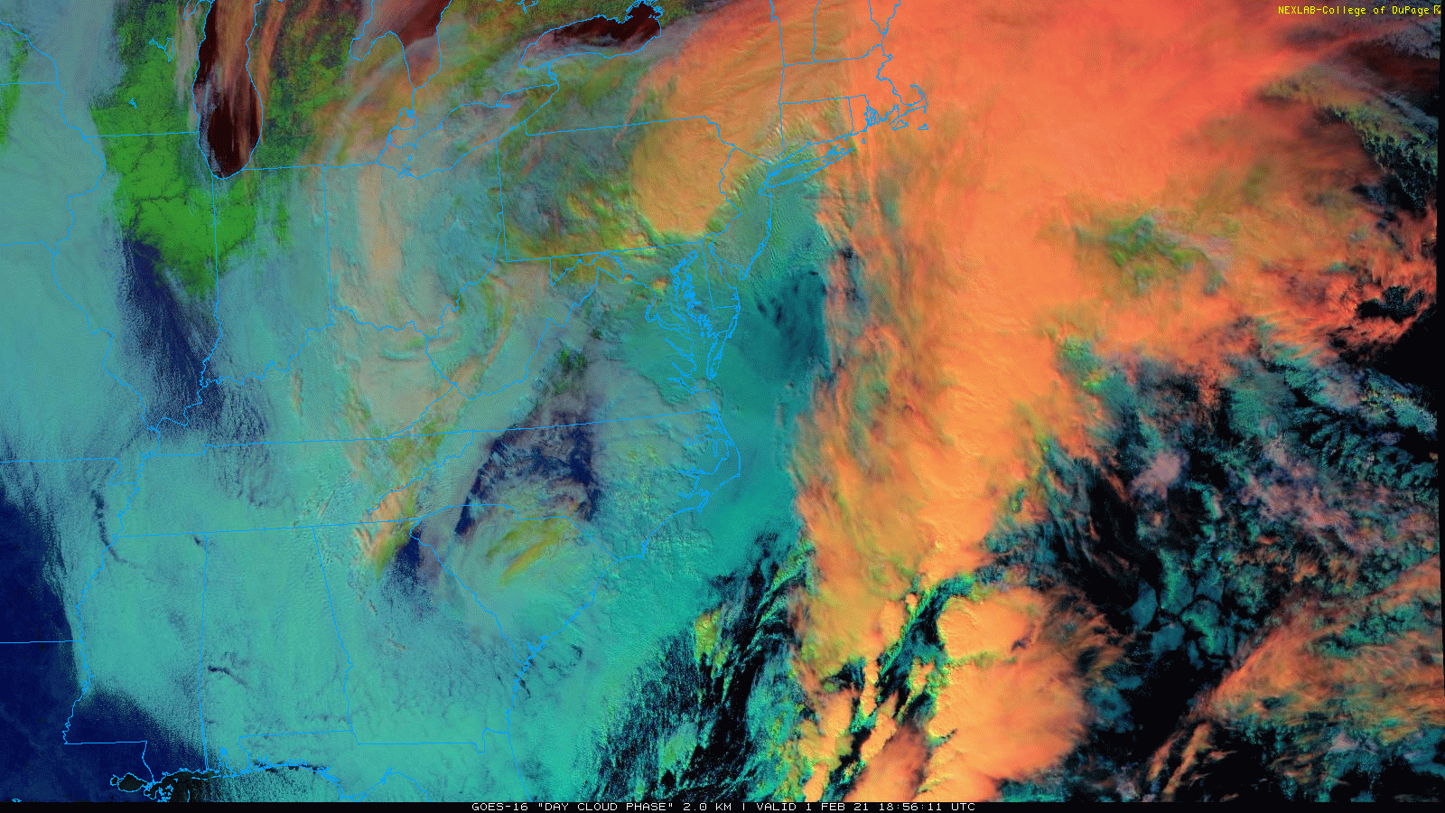
A major storm continues to intensify off the Mid-Atlantic coastline and it will have a big impact through tonight across the northern Mid-Atlantic region with strong winds and heavy snow. Images courtesy NOAA, College of DuPage
Overview
Low pressure continues to deepen off the Mid-Atlantic coastline and it will continue to have a major impact on the northern Mid-Atlantic through tonight in the area from eastern PA-to-New Jersey-to-southeastern New York. Mixed precipitation this morning has changed to snow in most places as colder air wraps into the system from the north/northeast. There will continue to be small-scale bands of very heavy snowfall from later today through tonight and many spots will end up with 1-2 feet of accumulation from this long duration storm system by the time it winds down later Tuesday.

An off-shore low pressure system continues to intensify at mid-afternoon and it has slowed down to a crawl as it has come under the influence of a strong blocking pattern to the north. Map courtesy NOAA
Details
The “overrunning” stage of this major winter storm is over and the second phase featuring intensifying low pressure just off the Mid-Atlantic coastline continues at mid-afternoon. The initial low pressure system over the Ohio Valley has dissipated and, as upper-level support reached the east coast earlier today, low pressure formed near the Carolina coastline and has since pushed northward to a location just to the east of the Delmarva Peninsula. This off-shore storm system is becoming increasingly under the influence of a strong blocking pattern in the atmosphere over the eastern part of Canada and its northward progression has slowed down to a crawl. As a result, the off-shore storm will continue to funnel abundant moisture from the Atlantic Ocean into the northern part of the Mid-Atlantic region and some of this will result in heavy snow over the next 6-12 hours.
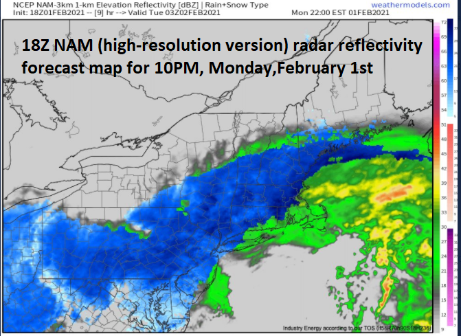
18Z NAM forecast map of radar reflectivity for 10PM, Monday, February 1st with snow (shown in blue) throughout much of the Mid-Atlantic region as a coastal storm sits just off the coastline. Map courtesy NOAA, weathermodels.com
In some spots along the I-95 corridor, the day began with mixed precipitation, but as the off-shore storm has stalled out, it has pulled in some colder air from the north/northeast. Those areas that had mixed precipitation earlier today have changed to snow this afternoon and the “wrap around” snow can fall heavily at times into tonight. The changeover to snow will take place all the way to the coastal regions of New Jersey and the Delmarva Peninsula and snow on the back side of the storm has actually pushed southward all the way into the DC metro region.

12Z Euro forecast map of “total snowfall amounts” between 7AM today and 7PM, Tuesday, February 2nd. Map courtesy ECMWF, Pivotal Weather
Here is a breakdown by metro region in the Mid-Atlantic’s I-95 corridor as to what to expect during the rest of this winter storm:
Philly, NYC metro regions:
Mixed precipitation has changed to snow in most areas and the snow can fall heavily at times later through tonight with significant additional accumulations. The winds will continue to be strong as the off-shore storm intensifies and can gust to 40 mph or so and 50+ mph gusts are possible along coastal sections. In fact, blizzard conditions are possible late today/tonight in the NYC metro region, upstate New Jersey, east-central/northeastern PA and perhaps as far south as the southeastern part of PA. Given very strong dynamics in the upper atmosphere, “mesoscale” or small-scale banding has formed with very heavy snowfall and these outbursts can continue through the night - perhaps even with a rumble or two of thunder. Occasional snow will continue on Tuesday and Tuesday night and there can be additional small accumulations. Many spots in the northern Mid-Atlantic will end up with 1-2 feet of snow accumulation from this long duration storm system by the time it winds down late Tuesday
DC metro region:
Mixed precipitation during the morning has now changed to snow in many portions of the DC metro region and there can be occasional snow during the rest of this afternoon, tonight, and even well into the day on Tuesday. The snow can be mixed with sleet and/or rain at times during this late stage of the long duration storm system. It is even possible that heavier “mesoscale” snow bands make their way all the way into the DC metro region (moving northeast-to-southwest) anytime from late this afternoon through later Tuesday. In fact, additional small snow accumulations are quite likely between now and late Tuesday; especially, in those areas that get hit by the localized heavier snow bands.

After a break in the cold late this week, it appears some very cold weather is coming to the central and eastern states next week as an anomalously cold air mass drops southward from northern Canada into the US. Map courtesy weathermodels.com, NOAA
Looking ahead to some very cold weather for much of the nation
Once we get past this long-duration major winter storm the weather may actually turn a bit milder towards the end of the week ahead of another strong cold front. There are signs, however, of a very cold second week of February in much of the central and eastern US. In fact, one of the coldest air masses of the winter will drop from Canada into the north-central US as there will be a big disruption to the circulation pattern from the North Pole to Greenland. This disruption will allow for the transport of some very cold air next week from the high to the middle latitudes.
Meteorologist Paul Dorian
Perspecta, Inc.
perspectaweather.com