
1:30 PM | ****The worst that winter has to offer next ten days across much of the nation…accumulating snow…significant icing…persistent cold that will be extreme in some areas****
Paul Dorian

Extreme cold will plunge all the way down to the Gulf coastal region by early next week with the possibility of “below zero” cold deep in the heart of Texas. Map courtesy NOAA, tropicaltidbits.com
Overview
The next ten days will bring the worst that winter has to offer too much of the nation which will include accumulating snow, significant icing and persistent cold that will be extreme in some areas. The energetic pattern of recent days will continue with storm-after-storm impacting the nation from coast-to-coast in this next ten day time period. Perhaps the best example of the most extreme winter weather that is on the way will take place deep in the heart of Texas where temperatures could drop to near zero by early next week and snow and ice can accumulate all the way down to the southeastern part of the state.
In the Mid-Atlantic region, one system will bring accumulating snow to areas near and to the north of the PA/MD border from tonight into early Thursday and it’ll produce a mixed bag of snow, sleet and rain in the DC metro region. A second and relatively weak system will have little or no impact on areas to the north of the PA/MD border on Thursday night and early Friday, but it can produce a small amount of snow in the DC metro region. A stronger system set to arrive this weekend will have more moisture to deal with than these first two and it could result in more significant ice and/or snow in the Mid-Atlantic region. And yes, there may be two other storms to deal with in the Mid-Atlantic region next week with significant snow and/or ice on the table for either or both of these systems.
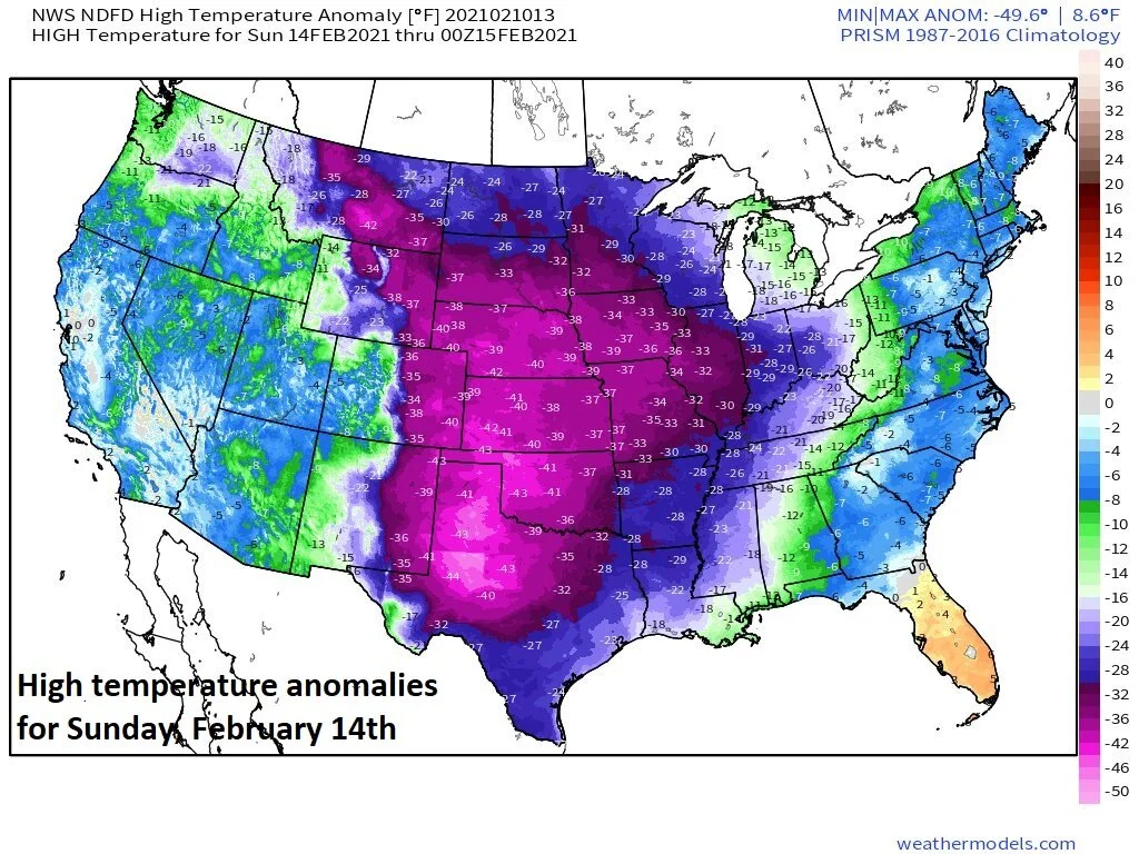
Abnormally cold air will extend from the Dakotas-to-Texas by the latter part of the weekend with temperatures some 25 to 40 degrees below normal for this time of year. Map courtesy NOAA, weathermodels.com
Details
Very cold air has been situated over much of the northern US during the past several days especially concentrated on the area from the interior Northwest to the Great Lakes. This entrenched cold air has been anchored by a deep upper-level low that has been sitting over the southern part of Canada and the longevity of the cold wave has been quite staggering. This anomalously cold air will make a move this weekend and plunge southward all the way down to the Texas Gulf coastal region by the early part of next week. In fact, temperatures by the latter part of the weekend could be as much as 25 to 40 degrees below normal all the way from the Dakotas-to-Texas and accumulating snow and ice could take place as far south as the southeastern (Gulf) coast of Texas. The lone exception to this cold air outbreak will be in the state of Florida as an upper-level ridge of high pressure is protecting this part of the nation.

Accumulating snow will fall tonight across northern Maryland, Pennsylvania, New Jersey and southeastern New York. A mixed bag of snow, sleet and rain is likely in the DC metro region. Map courtesy NOAA, Pivotal Weather
In the Mid-Atlantic region, one system will produce accumulating snow from tonight into early Thursday in areas near and north of the PA/MD border and a mix of snow, ice and rain is likely in the DC metro region. Accumulations by early tomorrow from this initial system should be as follows:
DC metro region: a coating to 2 or 3 inches with slightly higher amounts possible in the far northern and western suburbs…arrives between 5 and 7 PM…ends 6-8 AM on Thursday
Philly metro region: 2-5 inches with the higher amounts in this range in the southwestern suburbs (e.g., southern Chester County)…arrives tonight between 9 and 10 PM…ends 6-8 AM on Thursday
NYC metro region: 1-3 inches…arrives between 10 PM and midnight…ends 6-8 AM on Thursday.
A second system will produce some snow on Thursday night and early Friday, but its impact will be confined to areas south of the PA/MD border with small snow accumulations possible in the DC metro region.
A storm system over the weekend will likely move up towards the Mid-Atlantic coastline and it is likely to produce more snow, ice and rain in the region. It is too early yet for the finer details, but snow may be the dominant precipitation type in areas of the Mid-Atlantic region that lie to the north and west of the Route I-95 and the DC-to-Philly-to-NYC corridor could end up with a mixed bag of precipitation. This system pushes away later Sunday and then we’ll begin the new week with low-level cold air in place in the Mid-Atlantic region.

The overall pattern may become more conducive to significant ice storms this weekend and next week in the eastern half of the nation. Upper-level flow will be out of the southwest between a trough out west and a ridge over the western Atlantic and at the same time, cold low-level air will be locked into place across parts of the eastern US - a recipe for ice. Map courtesy NOAA, tropicaltidbits.com
Looking ahead to next week
Next week could feature another two storms that cross the nation in this very active ten day stretch. One system could impact the Mid-Atlantic region by Monday night or Tuesday and a second system could arrive just a few days later. Early signs point to the potential of high impact from either or both of these systems as there is likely to be plenty of available moisture and low-level cold air in place. In other words, there is the potential for significant snow and/or icing in the Mid-Atlantic region from either or both of these systems next week. Stay tuned on next week’s threats and lets end on a couple of positive notes…pitchers and catchers report in 7 days and a warm up is possible after we get through next week.
Meteorologist Paul Dorian
Perspecta, Inc.
perspectaweather.com
Follow us on Facebook, Twitter, YouTube
Video discussion: