11:45 AM (Saturday) | ***Coast-to-coast winter that includes significant snow, dangerous icing and historic cold***
Paul Dorian
NOAA has posted “watches and warnings” all across the nation in this very active wintry weather pattern.
Overview
Arctic air has gripped much of the northern and central US in recent days and it is plunging later this weekend to Texas and Oklahoma where the cold may be historic with all-time low temperature records likely being challenged in some spots. The longevity of this on-going cold wave across the northern and central US has been rather amazing with many areas experiencing bitter cold conditions for numerous days. In addition to the widespread and extreme cold, significant snow has accumulated in some regions including the Pacific Northwest (e.g., Seattle, Portland) and it is now moving into the Rocky Mountain States. Later in the weekend, this snow will spread into the far southern states of New Mexico, Oklahoma and Texas and ice will become a problem all the way down to the Gulf coast of Texas. Ice has already become a major headache today across parts of the Mid-Atlantic region including the DC metro region where several accidents have been reported and a significant ice buildup is underway. Unfortunately, a change in the upper part of the atmosphere will likely result in additional icing events in coming days across much of the nation.
The coldest core of the Arctic air mass relative-to-normal will push southward over the next 24-48 hours and the result will be historic cold in portions of Texas and Oklahoma. Maps courtesy NOAA, tropicalttidbits.com
Details
The upper-air wind flow has been rather zonal (west-to-east) in recent days across the Midwest and Mid-Atlantic region, but that is evolving into one with southwesterly winds aloft. As a result, there will be some warming in the upper parts of the atmosphere during the next several days, but cold, dense Arctic air at ground-level will be reluctant to give up its ground. The combination of some of this warming aloft and stubborn cold (and generally below-freezing cold) air at ground-level increases the chances of sleet and freezing rain and this is already producing big problems today in the Mid-Atlantic region.
Numerous record or near record lows this morning across the central and northern states. Map courtesy coolwx.com, NOAA
Freezing rain or freezing drizzle has taken place across much of Virginia, the DC metro area, and across the Delmarva Peninsula during the past few hours. This area of moisture is sliding to the north and east and sleet, freezing rain and perhaps even some snow will breakout in southeastern PA, New Jersey and NYC later in the day and early tonight. There have been several accidents reported earlier today in the DC metro region and a significant buildup of ice is likely by this evening. The icing threat will extend up the east coast later today into the northern Mid-Atlantic region while icing continues across the DC metro region. The best recommendation is to stay off the roads in the Mid-Atlantic region through tonight if it is indeed precipitating as the ground is very cold and conditions can quickly become dangerous.
Ice will be a serious problem in much of the Mid-Atlantic region by this evening (8PM forecast map shown). Map courtesy NOAA
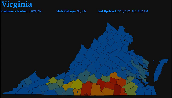
One thing to note, dew points are quite low in the northern Mid-Atlantic so that when the precipitation arrives later today/early tonight the surface temperatures are likely to drop quickly by a few degrees due to evaporative cooling. In other words, an already cold ground-level will get even colder. The total precipitation amounts in the southeastern PA, NJ and NYC region will be rather low from this system, but it doesn’t take much ice to cause issues; especially, on untreated surfaces. As far as power outages are concerned, they have already added up across southern Virginia and this threat will increase to the north and east over the next several hours as the ice continues to build up across DC and potentially in the northern Mid-Atlantic.
Power outages have increased in southern Virginia during the past few hours with the buildup of ice. This problem can extend to the north and east later today as icing pushes up along the I-95 corridor from DC-to-Philly-to-NYC.
Two storms next week
There are two significant storms on the table for next week that will bring significant snow to some parts of the nation, accumulating ice to others and plain rain as well. The current indications are that both of these systems are likely to take an inland track as they push into the eastern US (i.e., to the northwest of I-95). This kind of storm track would increase the chances for plain rain to the south and east of I-95 and perhaps even in the immediate I-95 corridor. Icing is, however, certainly still on the table for the DC-to-Philly-to-NYC corridor and accumulating snow cannot be ruled out. Significant snow is looking quite likely across the Ohio Valley and interior sections of the Northeast US with the potential inland storm tracks next week Stay tuned on next week’s two storms…many details still to be ironed out.
Meteorologist Paul Dorian
Perspecta, Inc.
perspectaweather.com
Follow us on Facebook, Twitter, YouTube


