
11:30 AM | ***Historic cold in central US…snow, ice storm TX/LA to Ohio Valley…icing tonight in Mid-Atlantic confined to areas well north/west of I-95…accumulating snow possible early Thursday***
Paul Dorian
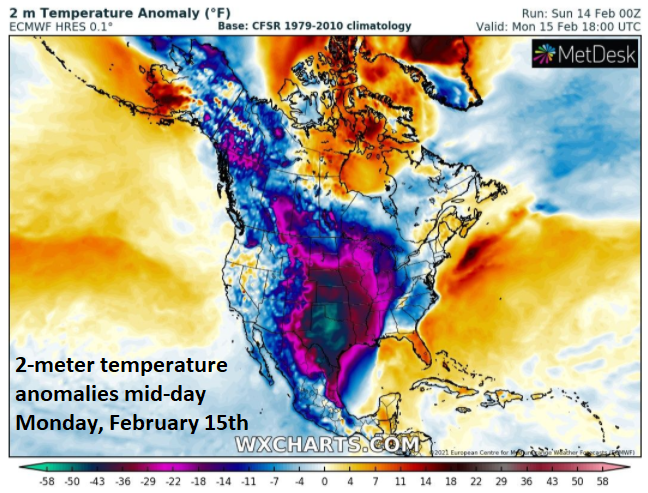
Parts of the central US are suffering through temperatures today that are 50+ degrees below normal for the middle of February. Map courtesy wxcharts.com
Overview
Historic cold has gripped much of the central/southern US today with many locations experiencing their all-time lowest temperatures and many other sites breaking their monthly (February) low temperature records. In addition, snow and ice has fallen in unusual places today all the way down to the Gulf coastal regions of Texas and Louisiana. The storm responsible for the snow and ice in the Deep South will now head towards the Tennessee and Ohio Valleys and bring a swath of accumulating snow and significant ice along its path.
As this storm heads well to the north and west of the Mid-Atlantic I-95 corridor, enough warmer air should move in to generate primarily a plain rain event later today and tonight for the metro regions with icing confined to the far northern and western suburbs. A second storm later in the week will have more cold air ahead of it than this initial system and this could result in a period of accumulating snow at the onset late Wednesday night/early Thursday before a likely changeover to a wintry mix.

Numerous places this morning experienced historic cold in the central US with several all-time low temperatures recorded and many other sites observed monthly (February) low temperature records. Map courtesy coolwx.com
Historic cold, accumulating snow and significant ice
Yesterday was the first time in memory that every single county in the state of Texas was under a “winter storm warning” as issued by NOAA’s National Weather Service. In fact, it was the first time in memory that even a “wind chill warning” was issued as far south as Houston, Texas which is located right near the Gulf of Mexico. Temperatures this morning plunged to all-time records lows in many spots from the Dakotas to Texas with a sampling listed below (still unconfirmed observations):
Yankton, South Dakota (-26°F)
Ord, Nebraska (-35°F)
Liberal Municipal, Kansas (-15°F)
Clinton, Oklahoma (-5°F)
Hondo, Texas (+8°F)
Fort Hood, Texas (+5°F)

Sustained cold in Europe this winter has resulted in a freezing of the River Thames near London (England) for the first time since 1963.
Perhaps one of the most amazing observations from earlier today was the report of “thunder snow” in Galveston, Texas with temperatures in the lower 20’s and still dropping. Another winter storm will impact Texas by mid-week with additional accumulating snow and ice. Power outages are widespread across Texas and, as the winter storm and significant icing pushes to the north and east, power outages could develop on a widespread basis across the Deep South, Tennessee and Ohio Valleys from later today into early Tuesday. Other parts of the country have also experienced some extreme winter weather with this storm and cold wave. For example, Minneapolis, MN is currently suffering through an unusually long stretch with “below-zero” temperatures and Seattle, WA had its biggest snowstorm since 1969. Even Europe has seen its fair share of extreme winter weather this season with, for example, the biggest snowstorm ever recorded in Madrid, Spain and, for the first time since 1963, the River Thames near London (England) is frozen.

Mid-Atlantic region…two storms to deal with this week
Given the storm track of this initial system well to the north and west of the I-95 corridor, the urban areas from DC-to-Philly-to-NYC should experience enough warming to prevent any serious icing issues later in the day and tonight. Precipitation will be only spotty and light this afternoon and evening and, by the time the heavier stuff arrives later tonight, it should be warm enough at low-levels for primarily plain rain in the immediate I-95 corridor. Any significant icing problems later tonight should be confined to locations well to the north and west of the DC, Philly, NYC urban areas. While temperatures will climb only slowly today to slightly above the freezing mark, they could rise late tonight when the heavier precipitation arrives and they should reach well up into the 40’s on Tuesday in DC, Philly and NYC.
While this initial storm system is looking somewhat warmer than it did a few days ago for the DC-to-Philly-to-NYC corridor, a second storm later in the week may actually turn out to be a bit colder than expected. A cold air mass should be in place at mid-week with strong high pressure to the north holding it in place. The ultimate storm track for this next system will likely be quite different from this initial system with a possible re-development near the Mid-Atlantic coastline. As a result, the chance of accumulating snow at the onset of the next storm system has increased for the DC-to-Philly-to-NYC corridor in the late Wednesday night/early Thursday time frame. Any snow that does develop at the onset of the late week storm is likely to change to a wintry mix later in the day on Thursday and there certainly can be a buildup of ice in parts of the Mid-Atlantic region on top of the possible accumulated snow. Stay tuned…something to monitor closely during the next few days.
Meteorologist Paul Dorian
Perspecta, Inc.
perspectaweather.com
Follow us on Facebook, Twitter, YouTube
Video discussion: