12:20 PM (Thursday) | ***A wintry mess possible late tonight/early Friday...late weekend storm threat for the Mid-Atlantic region…cold pattern locks in for much of the nation by later next week***
Paul Dorian

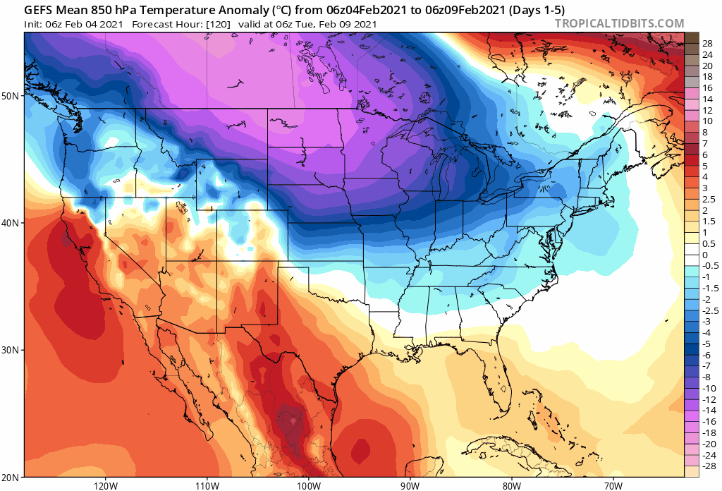
06Z GEFS rolling “5-day mean” of 850 mb temperature anomalies through the middle of the month with much of the nation experiencing colder-than-normal conditions. Maps courtesy NOAA, tropcialtidbits.com
Overview
Low pressure is impacting the Upper Midwest today with accumulating snow from Iowa to Wisconsin and it’ll push into the southeastern part of Canada by later tomorrow. A trailing strong cold front will slide into the eastern US on Friday and there can be a wintry mess of snow, sleet and/or freezing rain ahead of it in some suburban locations of the I-95 corridor from late tonight into early Friday. By later Friday, it’ll turn mild enough for just plain rain showers in the DC-to-Philly-to-NYC corridor and temperatures will likely climb into the 40’s.
Moderate cold air will follow the cold frontal passage for the upcoming weekend and attention will turn to the Gulf of Mexico and Southeast US where a lot of moisture will be gathering. A storm will develop in the southeastern states by early Saturday night and - depending on the interaction of two separate waves of energy aloft - it could end up pushing far enough to the north and east to have an impact the Mid-Atlantic region with accumulating snow - perhaps mixed with rain at times - from late Saturday night into mid-day Sunday. Looking ahead, very cold air will pour into the interior Northwest, Northern Plains, Upper Midwest and Great Lakes early next week and it looks like it will then spread to the Mid-Atlantic region at mid-week - potentially setting us up for an extended period of colder-than-normal conditions…and likely additional snow threats.

The 12Z NAM forecast map of 500 mb vorticity as of 7AM, Sunday, February 7th features a wave of energy over the Mid-Atlantic region (circled) and another disturbance in the northern branch of the jet stream over the Great Lakes. Map courtesy NOAA, tropicaltidbits.com
Late night/early Friday wintry mess
A strong cold front will cross the Upper Midwest/Great Lakes tonight and reach the eastern US on Friday and there can be a wintry mess of snow, sleet and/or freezing rain out ahead of it in the DC, Philly, NYC corridor from late tonight into early Friday. There is even a chance for some small accumulations of snow in some suburban location to the north and west of urban areas along the I-95 corridor before it becomes mild enough on Friday for just plain rain. A moderately cold air mass will follow the cold frontal passage for the upcoming weekend and attention will turn to a large area of moisture that is likely to gather over the Gulf of Mexico and Southeast US.

12Z NAM surface forecast map as of 7AM, Sunday, February 7th with snow (in blue) all along the immediate DC-to-Philly-to-NYC corridor. Map courtesy NOAA, tropicaltidbits.com
Late weekend storm threat
There will be two waves of interest this weekend in the upper part of the atmosphere that will play a role in the storm threat for the Mid-Atlantic region. One wave of energy will be moving along in the northern branch of the jet stream and a second disturbance will push be pushing through the southern branch. Depending on the interaction of these two upper-air systems, there can be a surface storm that can push far enough to the north and east to make an impact on the Mid-Atlantic region. The likely timetable for this potential system would be Saturday night into mid-day Sunday and with borderline cold air in place, the precipitation could be a combination of accumulation snow and some rain. A possible scenario would feature rain or a mix of rain and snow briefly at the onset and then primarily snow during the remainder of the event with a mix of rain and snow briefly at the end. This would likely be a relatively quick event and nothing like the “long-duration” winter storm of earlier this week. Snow accumulations of several inches are on the table in the DC-to-Philly-to-NYC corridor…stay tuned.

12Z GEFS forecast map of “ensemble members” pressure centers as of 1PM, Sunday, February 7th with strong support for low pressure off the Mid-Atlantic coastline. Map courtesy NOAA, tropicaltidbits.com
Looking ahead
While temperatures may bounce back and forth over the next 5 days or so in the Mid-Atlantic region, it looks like a more sustained period of colder-than-normal weather will begin around the middle of next week. Early next week, abnormally cold air for this time of year will invade the interior Northwest, Northern Plains, Upper Midwest and the Great Lakes with a widespread very cold air mass dropping southeastward to the northern US from southwestern Canada. This cold air mass will be supported by a very strong Canadian high pressure system that will edge slowly to the south and east later next week.

Daily highs and lows in coming days for Chicago, Illinois indicating there will be a sustained period of bitter cold for the “Windy City” with many days starting off with below zero temperatures. Map courtesy Weather Bell Analytics, NOAA
Initially, the brunt of this cold wave will be centered in the region from Montana to the Great Lakes, but it is likely to then edge its way into the Mid-Atlantic region around the middle of next week. Once here, it looks like it will stay colder-than-normal for an extended period of time across not only in the Mid-Atlantic region, but across much of the nation. An especially hard hit region during this upcoming cold wave will be the Upper Midwest where places like Chicago, Illinois are likely to experience multiple days with below zero chill. There is even the chance for some bitter cold air in the Mid-Atlantic region during this upcoming extended stretch of colder-than-normal weather - perhaps just in time for Valentine’s Day.

00Z ECMWF EPS forecast map of 2-meter temperature anomalies for days 6-10. Map courtesy WSI, Inc., ECMWF
In addition to the cold, there will continue to be plenty of energy in the atmosphere as the overall active weather pattern continues. Of particular interest, the southern branch of the jet stream looks like it will be rather “juiced up” with plenty of energy and moisture. This kind of weather pattern could result in the type of storm that comes out of the Gulf of Mexico and moves up along the east coast – perhaps something to watch for in the Friday/Saturday time period of the end of next week (February 12-13). If this system were to come to fruition, it could be the catalyst for some bitter cold air to push into the Mid-Atlantic region.
Stay tuned…an interesting weather pattern unfolding for the next couple of weeks.
Meteorologist Paul Dorian
Perspecta, Inc.
perspectaweather.com
Follow us on Facebook, Twitter, YouTube
Morning video discussion: