10:30 AM (Wed) | ****First significant severe weather outbreak of the season…soaking rain event coming to the Mid-Atlantic/Northeast US…rain changes to snow in many areas by early Friday****
Paul Dorian

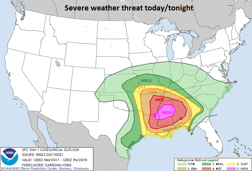
Probabilities of severe weather for today and tonight as depicted by NOAA’s Storm Prediction Center
Overview
A very active weather pattern for the eastern half of the nation during the next few days which will include the first significant severe weather outbreak of the season, the first soaking rain event in weeks across the Mid-Atlantic/Northeast US, and a changeover of rain-to-accumulating snow in many areas. Severe thunderstorms later today and tonight in the Deep South/Tennessee Valley will be capable of producing torrential rainfall, large hail, damaging wind gusts and tornadoes. A particularly dangerous situation is likely to develop later today in the Mississippi/Alabama region where numerous ingredients are coming together for high probabilities of severe weather. The severe weather threat will shift eastward to the Carolinas and Virginia on Thursday and continue into early Friday. The same storm system that will be contributing to the severe weather outbreak will result in a soaking rain event for the Mid-Atlantic/Northeast US on Thursday and Thursday night – the first significant rainfall in weeks in many of those locations. As colder air wraps into the low pressure system later tomorrow night, rain will change to snow in a northwest-to-southeast fashion and there can be snow all the way down into the DC-to-Philly-to-NYC corridor by early Friday.

Probabilities of severe weather for tomorrow and tomorrow night as depicted by NOAA’s Storm Prediction Center
Significant severe weather threat today into Friday
Strong upper-level low pressure will push eastward today from the middle of the country to the lower Mississippi Valley. Surface low pressure is now intensifying over Oklahoma as this strong upper-level system passes overhead and this system will push to the northeast later in the day. A north-to-south oriented cold front trails the surface low pressure system into south-central Texas and a warm front extends to its east into the Tennessee Valley.
Severe thunderstorms may come in 3 different rounds for some spots of the Deep South/Tennessee Valley later today and tonight as there will be three different regimes impacted in this overall storm system as follows: (1) along and just to the north of the northeastward-advancing warm front (2) in the warm sector behind the warm front and ahead of an eastward advancing cold front and (3) along and just ahead of the cold front.
Thunderstorms have already formed along and just to the north of the warm front this morning from Arkansas to the northern parts of Mississippi and Alabama to southern Tennessee and they will intensify later this morning and mid-day. Severe thunderstorms are likely to form in the warm sector later this afternoon and into the early evening across the Deep South. Thunderstorms already exist just ahead of the cold front in eastern Texas and these will intensify as they push eastward later in the day. A particularly dangerous situation is likely to develop later today in the Mississippi/Alabama region where numerous ingredients are coming together for high probabilities of tornadic activity. The overall severe weather threat will shift to the Carolinas and Virginia from Thursday into Friday as the surface low pressure system reaches the Ohio Valley and then drops south and east to just off the Mid-Atlantic coastline by early Friday.

Deep upper-level trough of low pressure will contribute to the first significant severe weather outbreak of the season so far in the Deep South/Tennessee Valley/Carolinas and also to the first significant precipitation event of the month in the Mid-Atlantic/Northeast US. Map courtesy NOAA, tropicaltidbits.com
Mid-Atlantic/Northeast US soaking rain-to-snow
Once low pressure reaches the Ohio Valley early Thursday, it will encounter a strong blocking pattern in the upper atmosphere across southern Canada. As a result, the low will no longer be able to push to the north and will be “forced” to take a turn to the south and east – ultimately ending up off the Mid-Atlantic coastline by early Friday. Rain will spread into the Mid-Atlantic region/Northeast US on Thursday and become heavy at times into tomorrow night and there can even be some thunderstorm activity. This will be the first significant precipitation event of the month of March in many areas as it has been an unusual extended dry spell.

Rain will change to snow from northwest-to-southeast late Thursday night into Friday morning across the Mid-Atlantic/Northeast US. Map courtesy NOAA, tropicaltidbits.com
Meanwhile, strong high pressure will build into southeastern Canada on Thursday and - as the surface low takes its turn to the south and east - colder air will follow and drop southeastward from southeastern Canada into the Mid-Atlantic/Northeast US. As a result, the rain will change to snow in a northwest-to-southeast fashion later tomorrow night into early Friday with the first area to see the changeover being in the northern and western interior sections of the Mid-Atlantic/Northeast US. By early Friday, there is likely to be a mixing with or a complete changeover to snow all the way down into the I-95 corridor region from DC-to-Philly-to-NYC. Snow accumulations are certainly on the table later tomorrow night/early Friday; especially, across the interior higher elevation locations of the Mid-Atlantic/Northeast US. Cold, dry air will take control in the northeastern quadrant of the nation for late Friday and Saturday, but a warm up begins on Sunday. In fact, temperatures should be back up in the 60’s early next week in the DC, Philly, and NYC metro regions.
Meteorologist Paul Dorian
Perspecta, Inc.
perspectaweather.com
Follow us on Facebook, Twitter, YouTube
Video discussion: