
12:20 PM (Tues) | *Soaking rain later tomorrow/tomorrow night then a cold blast follows for Thursday/Friday…temperatures likely to drop to below freezing late at night - even in the I-95 corridor*
Paul Dorian

A much colder-than-normal air mass will blast into the eastern US on Thursday and it may result in near record or record lows early Friday and again early Saturday. Map courtesy NOAA, tropicaltidbits.com
Overview
Another soaking rain event is headed to the region extending from the Tennessee Valley to the Mid-Atlantic and it will be followed by an impressive cold blast for the beginning of April. The soaking rain will push northeastward on Wednesday from the Tennessee Valley into the Mid-Atlantic; primarily, for the afternoon and nighttime hours. All of this activity will take place just ahead of a strong cold front which will usher in much colder air for Thursday and Friday and there can even be some accumulating snow when it arrives; primarily, across interior sections of the Mid-Atlantic and Northeast US.
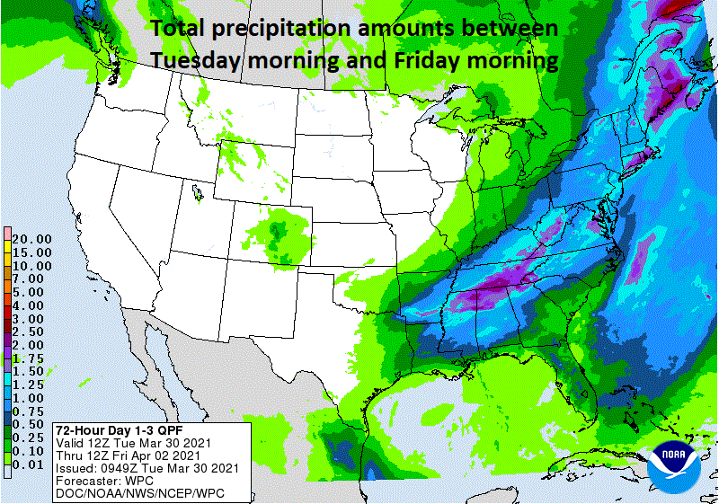
A soaking rain event is coming to the Tennessee Valley and Mid-Atlantic region from later tomorrow into tomorrow night. Total precipitation amounts are shown on this NOAA forecast map for the 72-hour period from Tuesday morning to Friday morning.
Details
The major league baseball season is scheduled to get underway on Thursday and the weather will not exactly cooperate in the northeastern quadrant of the nation. Not only is a much colder-than-normal air mass going to arrive on Thursday (Opening Day), winds will become quite strong from a northwesterly direction and accumulating snow can actually fall; especially, across interior sections of the Mid-Atlantic/Northeast US.
The cold blast will be preceded by a soaking rain event from later tomorrow into tomorrow night with multiple ingredients coming together in the Mid-Atlantic region. First, there will be a strong cold front pushing in this direction from the northwest and it will be “slowing down” in its forward motion. Second, a vigorous wave of energy in the upper atmosphere will parallel the front increasing the chance for the “training” of thunderstorms. And finally, low pressure will intensify as it pushes northeast along the frontal boundary zone. Rain, possibly heavy at times, will develop by Wednesday afternoon in the Mid-Atlantic/Northeast US and continue into tomorrow night and there can be a strong thunderstorm or two mixed into the picture.

Bryce Harper at Citizens Bank Park in Philly (image courtesy CBS Sports)
By later tomorrow night, colder air will begin to pour into the Mid-Atlantic/Northeast US following the passage of the cold front and the rain is quite likely to change to accumulating snow across interior sections of the Mid-Atlantic/Northeast US from West Virginia to northern New England. Temperatures are likely to hold in the 40’s on Thursday in the I-95 corridor and there can even be some snowflakes mixed into the picture in the morning in the immediate DC-to-Philly-to-NYC corridor. Winds will become quite strong from the northwest by Thursday afternoon and those strong winds will persist right into Friday. Baseball’s home openers on Thursday afternoon in places like Washington, D.C. (Nationals vs. Mets), Philly (Phillies vs. Braves) and New York City (Yankees vs. Blue Jays) will unfortunately feature quite nasty weather conditions with high winds, chilly temperatures for the first day of April, and maybe even a snow shower or two.

The late week cold blast will be associated with a deep upper-level low in the northeastern part of the nation on Thursday which can result in accumulating snow across interior sections. Map courtesy NOAA, tropicaltidbits.com
Temperatures in the overnight hours on Thursday night/early Friday are likely to drop to below the freezing mark – even in the immediate I-95 corridor – and this could be a problem for some sensitive plants. In fact, temperatures are likely to drop to below freezing again in this same area on Friday night/early Saturday before some modification takes place during the upcoming Easter weekend. Don’t be surprised to see plenty of near record or record lows early Friday and again early Saturday all the way from New England down to Florida with this impressive late week cold blast.
Meteorologist Paul Dorian
Perspecta, Inc.
perspectaweather.com
Follow us on Facebook, Twitter, YouTube
Video discussion: