12:20 PM (Wed) | *Soaking rain later today into early Thursday with cold blast to follow…temperatures to drop to or just below the freezing mark…some snowflakes in the mix as well*
Paul Dorian

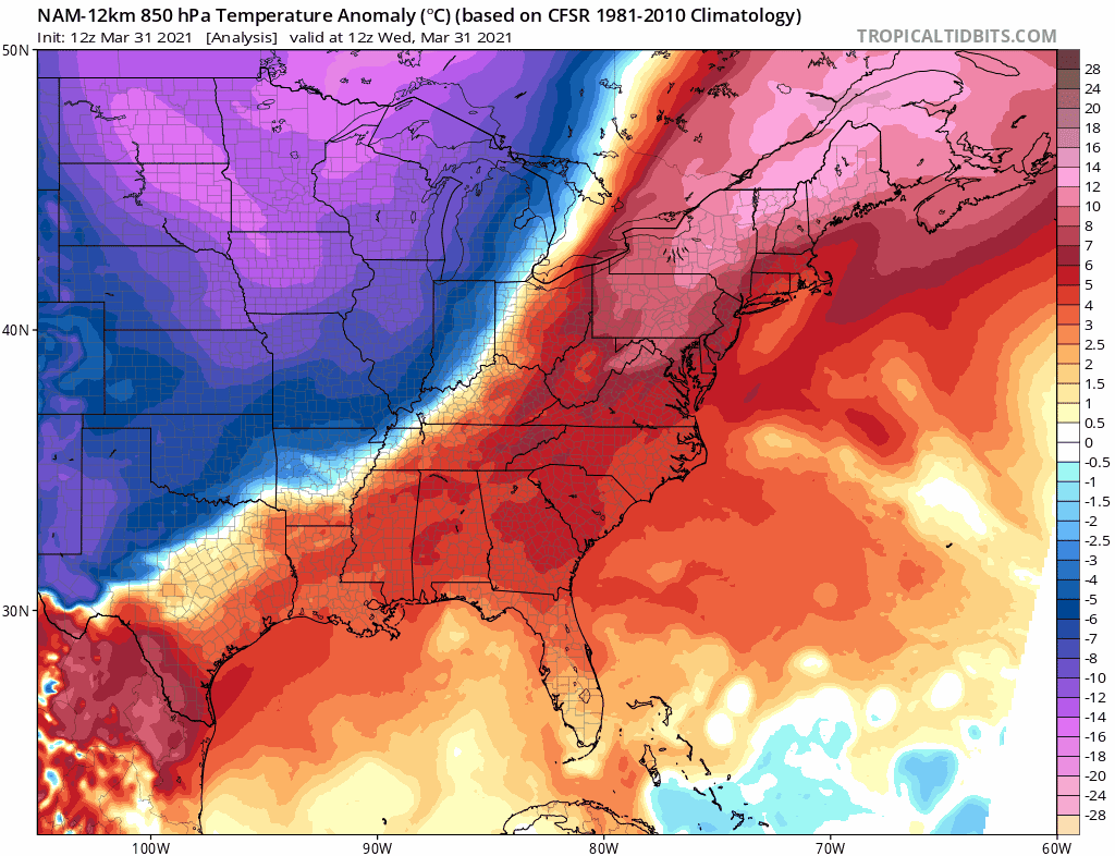
Here comes the cold blast…colder-than-normal air will flood the eastern US on Thursday riding in on increasingly strong NW winds. Maps courtesy NOAA, tropicaltidbits.com
Overview
Soaking rain is headed to the Mid-Atlantic region for later today, tonight and early Thursday and it will be followed by an impressive cold blast for the beginning of the month of April. Temperatures will drop sharply late tonight/early tomorrow following the passage of a strong cold front and winds will become increasingly strong from a northwesterly direction. This cold air outbreak will result in accumulating snow on Thursday across interior sections of the Mid-Atlantic/Northeast US from West Virginia to northern New England and some snow can actually fall all the way down into the immediate I-95 corridor. Temperatures late tomorrow night and again late Friday night are likely to fall to or just below the freezing mark in many spots, but the unusual chill will ease during the upcoming Easter weekend. One final note, tomorrow is Opening Day for Major League Baseball in many Mid-Atlantic/Northeast US locations…if attending one of these games, better bring a winter coat.

Rain is closing in on the DC metro region at mid-day and will push into Philly and New York City later in the afternoon and continue into early Thursday. Radar images courtesy College of DuPage, NOAA
Details
A cold blast will arrive in the Mid-Atlantic/Northeast US on Thursday and it will be preceded by a soaking rain event from later today into early tomorrow. Multiple ingredients are coming together for the soaking rain that will push into the DC-to-Philly-to-NYC corridor during the afternoon hours. First, a strong cold front that is pushing in this direction from our northwest will tend to slow down as it approaches the eastern seaboard. Second, a vigorous wave of energy in the upper atmosphere will tend to “parallel” the front increasing the chance for the “training” of thunderstorms and heavier rain cells. And finally, a third ingredient will be low pressure that will intensify as it pushes northeastward along the frontal boundary zone.

Soaking rain is coming to the Mid-Atlantic region with anywhere from 0.75-1.50 inches likely during the next 24 hours or so. Map courtesy NOAA, tropicaltidbits.com
On Thursday, colder air will begin to pour into the Mid-Atlantic/Northeast US following the passage of the cold front and the rain is quite likely to change to accumulating snow across interior sections from West Virginia to northern New England. Temperatures are likely to hold in the 40’s on Thursday in the I-95 corridor and there can even be some snow that makes its way all the way down to the immediate I-95 corridor on Thursday morning. Winds will become quite strong from the northwest by tomorrow afternoon and those strong winds will persist right into the day on Friday. The weather conditions will not be pleasant for the Opening Day of major league baseball on Thursday in such places as Washington, D.C. (Nationals vs. Mets), Philadelphia (Phillies vs. Braves) and New York City (Yankees vs. Blue Jays) where high winds and chilly temperatures will make it quite uncomfortable for the fans…yes, the fans return for the first time since the 2019 season - at least in some limited capacity.
Temperatures by early Friday morning are likely to drop to or just below the freezing mark – even in the immediate I-95 corridor – and this could be a problem for some sensitive plants. In fact, temperatures are likely to drop to or just below the freezing mark again late Friday night/early Saturday before some modification takes place during the upcoming Easter weekend. Don’t be surprised to see plenty of near record or record lows early Friday and again early Saturday all the way from New England down to Florida with this impressive early April cold blast.
Meteorologist Paul Dorian
Perspecta, Inc.
perspectaweather.com