2:50 PM (Thursday) | *Just can’t seem to shake off the cold*
Paul Dorian

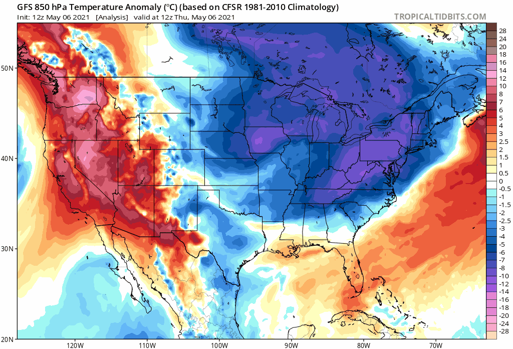
The overall weather pattern that is unfolding will bring numerous colder-than-normal air masses into the central and eastern US in coming days. Maps courtesy NOAA, tropicaltidbits.com
Overview
The overall weather pattern that is unfolding is going to disappoint those in the eastern 2/3rds of the nation who are looking for sustained warmth as we progress through the month of May. In fact, signs point to a continuation of colder-than-normal outbreak into this large stretch of the nation well into the second half of May. In some cases, these cold air outbreaks will result in low temperatures near or below freezing which is a threat to growers from the Rockies-to-Northern Plains-to-Upper Midwest and in some cases this pattern will result in significant accumulating snow (e.g., higher elevations in the Rockies).

Accumulating snow will continue in coming days across the Rockies with significant amounts possible in some of the highest elevation locations. Map courtesy NOAA, tropicaltidbits.com
Details
Teleconnection indices known as the Arctic Oscillation (AO) and North Atlantic Oscillation (NAO) have been generally in “negative” territory in recent days and this is often correlated with cold air outbreaks this time of year into the central and eastern US from central Canada. Indeed, that has been the case in much of the spring so far and it looks like it will continue well into the month of May. In fact, temperatures will fall as much as 20+ degrees below normal in coming days across parts of the nation which could bring surface temperatures to near freezing for overnight lows. Low temperatures that are at or below freezing this time of year would, of course, be concerning to growers and the likely problematic areas will stretch from the Rockies-to-the-Northern Plains-to-the Upper Midwest.

A breakdown of surface temperature anomalies next ten days (days 1-5, left; days 6-10, right) by yesterday’s European model. Maps courtesy WSI, Inc., ECMWF
In addition to the colder-than-normal temperature pattern, there will be numerous upper-level disturbances passing over the nation and these are likely to result in chilly rain in some areas and even accumulating snow in other areas such as the higher elevation locations in the interior western US. One such wave of energy in the upper atmosphere will spin over the northeastern quadrant of the nation on Friday and this will result in unstable conditions with unusually chilly air aloft. Any kind of early day low-level heating on Friday and Saturday in the Mid-Atlantic/Northeast US will act to destabilize the atmosphere and scattered mid-day and afternoon showers may be the result to go along with cooler-than-normal temperatures. By early next week, another deep upper-level trough will slide over the northeastern states resulting in more cool, unsettled weather and there will be a strong system digging into the southwestern US as well. That western system early next week could result in more accumulating snow in the interior western states; especially, for some of the higher elevations in the Rockies as the chilly spring continues out there and across much of the nation.
Meteorologist Paul Dorian
Perspecta, Inc.
perspectaweather.com