
1:00 PM | *Watching the Gulf of Mexico…tropical system likely to head towards the central Gulf States…could bring rainfall to the Mid-Atlantic early next week ahead of yet another cool blast*
Paul Dorian

A tropical storm is likely to be nearing the central Gulf coast by early this weekend. Map courtesy NOAA, tropicaltidbits.com
Overview
There have been a couple of named tropical systems so far in the Atlantic Basin, but neither one was of much consequence and had little to no impact on the US mainland. A third tropical wave now drifting over Bay of Campeche and southern Mexico is likely to intensify into at least tropical storm status in coming days as it turns to the north, if so, it would become named “Claudette”. The track of this system is likely to bring it to the central Gulf coastal region during the early part of the upcoming weekend and then its remains are likely to push northeastward into the Tennessee Valley on Sunday and then the Carolinas/Virginia on Monday. There is even a chance that the remains of the tropical system strengthen after moving over land - contrary to normal trends for tropical systems - and it could get intertwined with an approaching cold frontal system to produce rainfall in the Mid-Atlantic region early next week.

A tropical wave is meandering around the Bay of Campeche (“X” on the map), but it should begin a move to the north on Thursday and likely intensify into a named tropical storm. Map courtesy NOAA/NHC
Details
A tropical wave currently exists over the Bay of Campeche and southern Mexico and is producing a rather disorganized area of showers and thunderstorms. This system is meandering around this region today, but should begin a more accelerated push to the north on Thursday. As the tropical wave heads northward over the next couple of days, it will likely intensify and reach tropical storm status which would result in it acquiring the name “Claudette”. On Saturday, this tropical system is quite likely to be approaching the central Gulf states of Louisiana/Mississippi and some heavy rainfall is a strong possibility. It appears the heaviest rainfall associated with this system will take place on the eastern side of its track putting Alabama in a threat zone as well as Louisiana and Mississippi.
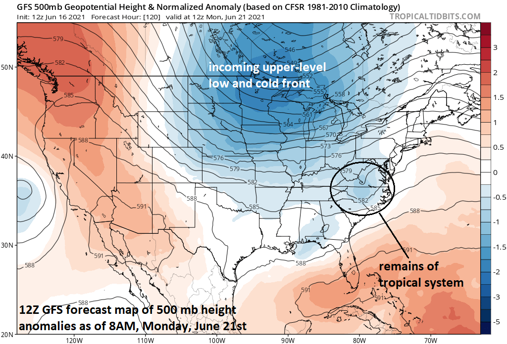
The interaction between an incoming upper-level low/surface cold front and the tropical system will dictate how far north and east its leftover rainfall can come. Map courtesy NOAA, tropicaltidbits.com
After landfall, the remains of this tropical system are likely to push to the northeast and some heavy rainfall will be a possible outcome on Sunday in the Tennessee Valley and then on Monday in the Carolinas and Virginia. There is even a chance that this storm intensifies some over land which is contrary to the usual trend for tropical systems after making landfall. At the same time this system pushes to the northeast in the eastern states, a strong upper-level low pressure will be dropping southeastward from central Canada into the northern US and it’ll feature a strong surface cold front. Depending on the ultimate interaction between the approaching upper-level low/surface cold front and the tropical system, there could be some decent rainfall pushing all the way into the northern Mid-Atlantic region later Monday and Monday night…still a little early to know for certain.

Yet another refreshing air mass will reach the Mid-Atlantic/NE US/Great Lakes by the middle part of next week. Map courtesy NOAA, tropicaltidbits.com
Whether or not leftover rains make it into the northern Mid-Atlantic early next week, another very comfortable air mass is destined to push into the northeastern quadrant of the nation by the middle of next week. Much like the current air mass over the Great Lakes/Mid-Atlantic/Northeast US, days will be comfortably warm during the middle part of next week and nights will be refreshingly cool - no matter how much rain falls in the early part of next week.
Meteorologist Paul Dorian
Peraton
peratonweather.com
Follow us on Facebook, Twitter, YouTube
Video discussion: