11:10 AM (Thursday) | *Intense heat in the Pacific Northwest in the near-term…strong tropical wave exits off of Africa and may become a concern for the Southeast US/Gulf of Mexico in the longer-term*
Paul Dorian

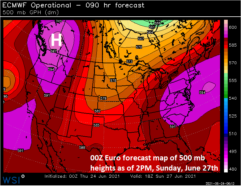
Heat will intensify later this weekend across the Pacific Northwest as high pressure ridging intensifies over southwestern Canada. Map courtesy WSI, Inc., ECMWF
Overview
One big weather story in the near-term that will likely become a big news story is the heat that will intensify across the Pacific Northwest later this weekend and early next week. As high pressure expands and intensifies over the Pacific Northwest later this weekend, many places including Seattle, Washington will approach or surpass the 100 degree mark for afternoon highs. In fact, Portland, Oregon could actually surpass their all-time high temperature record of 107°F on Sunday afternoon. In the longer-term, another weather story may develop across the tropics. A strong tropical wave has just exited off the west coast of Africa and signs point to a favorable pattern for intensification down the road potentially leading to problems for the Gulf of Mexico/Southeast US by the time we get to the early part of July.
Intense heat for the Pacific Northwest
There has been quite comfortable weather for much of the month of June across the northeastern quadrant of the nation including the Great Lakes, Mid-Atlantic and New England. In fact, overall temperatures for June have been pretty close-to-normal in such places as Washington, D.C., Philadelphia and New York City. At the same time, there has been intense heat across the southwestern states with places like Phoenix, Arizona soaring to well above-normal levels in the last week or two. The intense heat will shift over the next couple of days to the Pacific Northwest as high pressure aloft intensifies and expands in that part of the nation.

Intense heat will envelope the Pacific Northwest later this weekend and early next week as high pressure ridging intensifies overhead. Map courtesy NOAA, tropicaltidbits.com
With the high pressure ridging building in the upper part of the atmosphere later this weekend, temperatures will respond by soaring to the century mark in many areas. High pressure aloft acts as a “heat dome” as it helps to generate downward motion in the atmosphere and drying/warming air. In addition, surface winds will likely become easterly (i.e., offshore) across much of the Pacific Northwest which is a warming type of flow. As an example of the potential intensity of the heat, Seattle, Washington could reach the 100 degree mark for highs on both Sunday and Monday and Portland, Oregon might actually surpass their all-time high temperature record of 107°F. While the upper-level high shifts to the Pacific Northwest, the central Plains will see a reversal in their recent pattern with intensifying upper-level troughing which is likely to lead to a cool down in that part of the nation by early next week. In the Northeast US, the comfortable conditions of the past few days will give way to very warm and humid conditions this weekend and early next week as high pressure ridging builds overhead in that part of the nation as well.
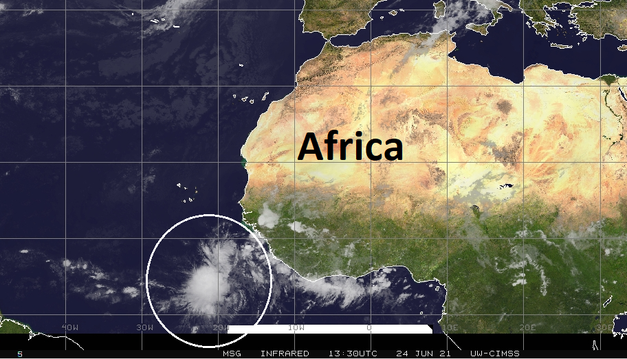
An impressive tropical wave ha just exited off the west coast of Africa and it bears watching in coming days as overall atmospheric conditions are pretty favorable for development/intensification. Credit for satellite image goes to University of Wisconsin/CIMSS, NOAA
Tropical Wave off the west coast of Africa
An impressive tropical wave has just exited off the west coast of Africa and it is something to watch as we head through the late stages of June and could very well become an important player for the Gulf of Mexico/Southeast US by the time we get to the early part of July. So far this Atlantic Basin tropical season, there have been a few “home-grown” type systems that formed near the US mainland, but this system falls into the category of an “African-wave”.
There are a couple of factors that suggest this system bears watching in coming days. First, vertical wind shear is quite low across the tropical Atlantic which will limit any potential disruption to the circulation around this system. Second, while Atlantic Ocean water is cooler-than-normal just off the west coast of Africa, sea surface temperatures are nearly normal or even slightly warmer-than-normal in the western Atlantic which should support tropical storm development and/or intensification. Still a lot of distance between this new system and the Southeast US/Gulf of Mexico, but it is something to watch in coming days.
Meteorologist Paul Dorian
Peraton
peratonweather.com
Follow us on Facebook, Twitter, YouTube
Video discussion: