2:45 PM (Thursday) | ***Strong-to-severe storms/torrential rain in the Mid-Atlantic as we break the back of the heat wave…”Elsa” is born and is a threat to the SE US***
Paul Dorian

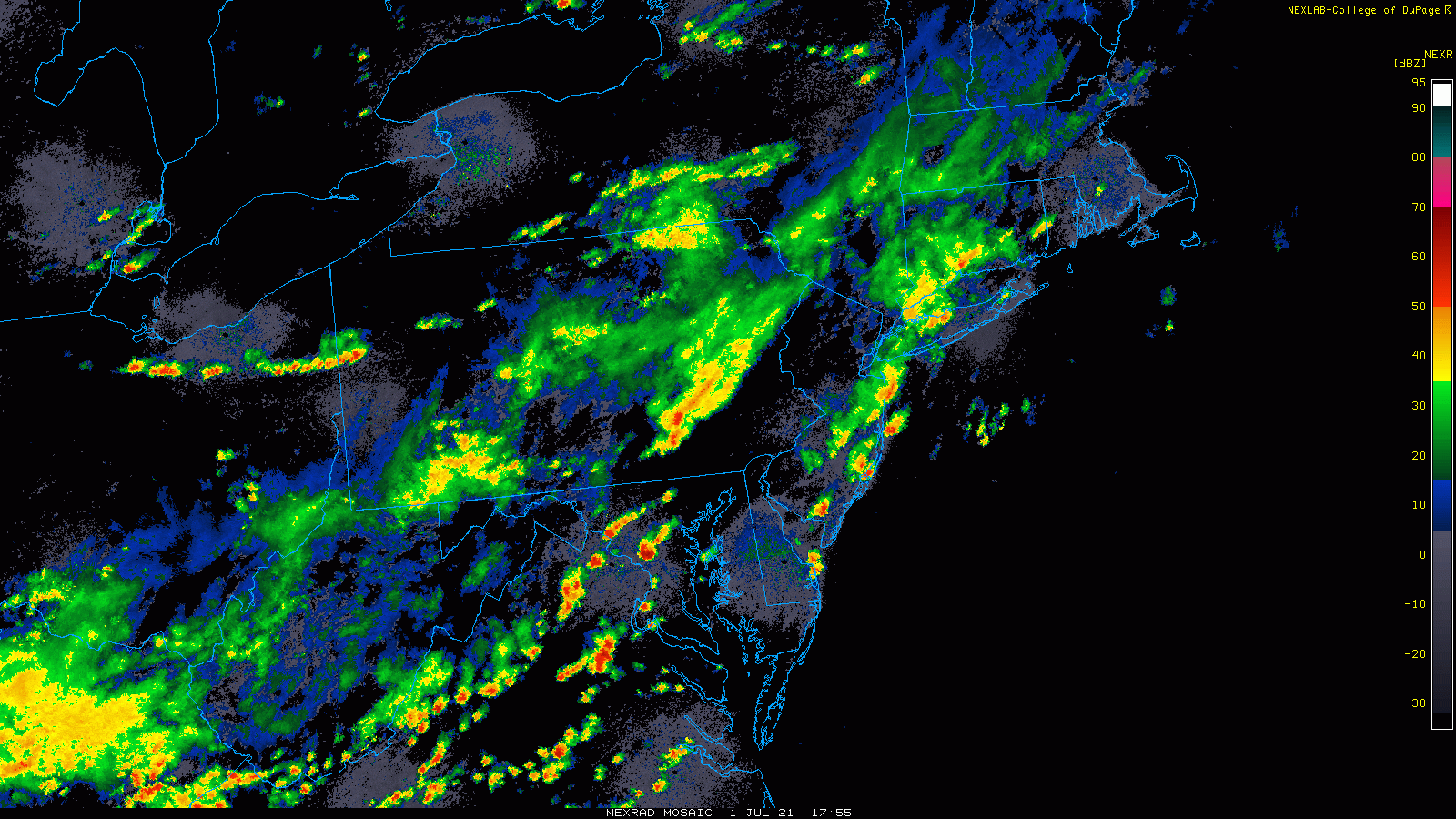
Strong-to-severe thunderstorms will impact the I-95 corridor through tonight with torrential rainfall and possible damaging wind gusts. Maps courtesy College of DuPage, NOAA
Overview
It’s never easy to break the back of a heat wave in the Mid-Atlantic region and this one will be no different with the formation of strong-to-severe thunderstorms in the transition and there will be torrential rainfall included in the mix. The threat for storms and heavy rainfall will continue into Friday as a slow-moving cold front works its way through the region. It’ll turn noticeably cooler on Friday and Saturday and the weather will stay unsettled as we begin the holiday weekend, but improvement will set in for Sunday and Monday.
Elsewhere, an impressive tropical wave that exited off of the west coast of Africa last week has strengthened into Tropical Storm “Elsa” and it will enter the Caribbean Sea later tomorrow. This system is likely to become an important player for the Caribbean islands of Hispaniola (Haiti/Dominican Republic), Jamaica and Cuba later in the weekend and could threaten southern Florida early next week.

The bad news is that an upper-level low is be over the Mid-Atlantic region as we begin the holiday weekend….the good news is that it will push away later in the weekend allowing for noticeable improvement in the weather. Map courtesy NOAA, tropicaltidbits.com
Strong-to-severe storms/torrential rain in the Mid-Atlantic
Temperatures have been knocked down some today with an abundance of clouds but dew points have remained in uncomfortable levels in the DC-to-Philly-to-NYC corridor as a cold front slowly. Strong-to-severe thunderstorms have formed and can impact at any time through tonight with damaging wind gusts and torrential rainfall. Watch for localized flooding in this situation as some spots can receive 2, 3, even 4 inches of rain in a relatively short period of time. The threat for heavy rain will continue into Friday as well as an upper-level low begins to drop southeastward from the eastern Great Lakes and towards the Mid-Atlantic.
It turns noticeably cooler on Friday and the weekend will get off to a cooler-than-normal start. It stays unsettled on Saturday with an upper-level low overhead likely resulting in additional showers and thunderstorms. The weather does improve later in the weekend, however, showers cannot be ruled out for the 4th of July (Sunday). Much more improvement is likely by the time we get to the Monday (July 5th) holiday with plenty of sunshine returning and that will help to boost temperatures into the 80’s for highs after being confined to the 70’s earlier in the weekend.

Tropical Storm “Elsa” will enter the Caribbean Sea on Friday and likely threaten the northwestern Caribbean islands late in the weekend and potentially the southeastern US. Map courtesy NOAA
“Elsa” is born and may impact the SE US early next week
Tropical Storm “Elsa” has formed and it is headed to the Caribbean Sea by the weekend where there are more favorable sea surface temperatures compared to the eastern Atlantic Ocean. This system could then reach the northwestern part of the Caribbean Sea by the late weekend potentially impacting Hispaniola, Jamaica and Cuba. After that, there are signs that “Elsa” could take a turn to the north and perhaps impact southern Florida by the early part of next week…all residents in the southeastern US should closely monitor it in coming days.
Meteorologist Paul Dorian
Peraton
peratonweather.com
Follow us on Facebook, Twitter, YouTube