1:45 PM | *Fred, Grace and Henri, oh my…remnants of Fred pushing northward with significant rain…Grace headed west towards Yucatan Peninsula…Henri needs to be very closely monitored*
Paul Dorian

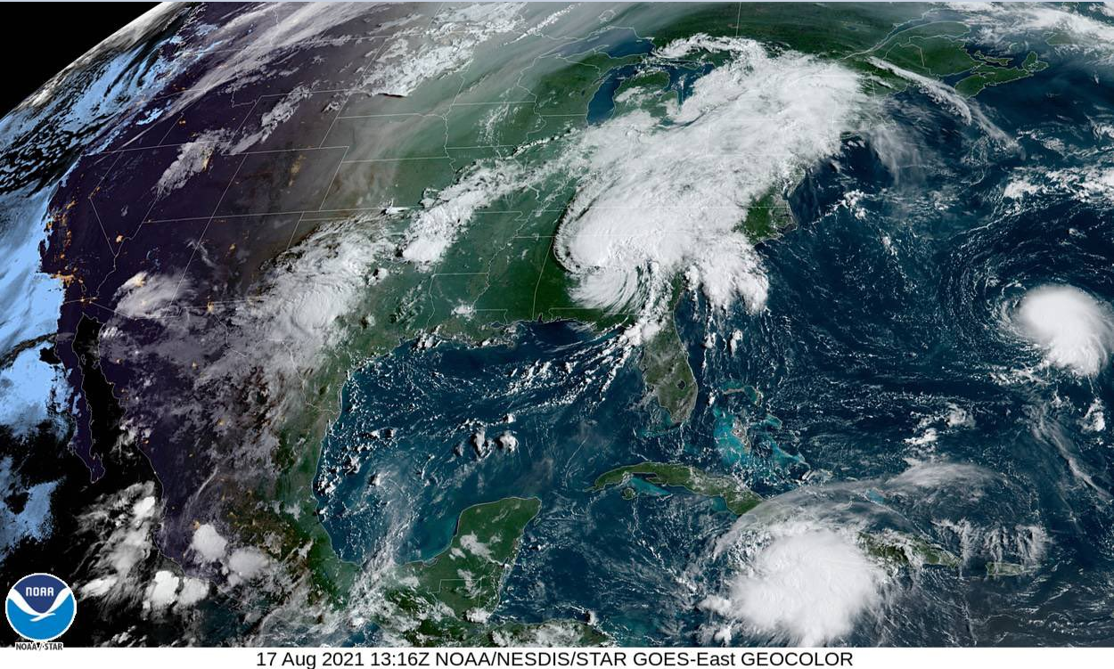
A spectacular satellite image of Fred (top), Grace (bottom) and Henri (far right)…courtesy NOAA/NESDIS
Overview
Tropical Storm Fred came ashore late yesterday in western Florida and the remains are now pushing north-northeastward across the northwestern part of Georgia. Despite its recent weakening, this system continues to produce some significant rainfall and strong thunderstorm activity in the Southeast US and Tennessee Valley and it will likely do so tomorrow and tomorrow night in the Mid-Atlantic region. Meanwhile, Tropical Storm Grace is moving westward through the Caribbean Sea and is likely to reach the Yucatan Peninsula region of Mexico by Thursday – probably as a hurricane. Finally, Tropical Storm Henri has formed over the Atlantic and is currently meandering not too far from the island of Bermuda. This system is quite worrisome in that it may come awfully close to the US east coast before hopefully turning away…needs to be very closely monitored.

Specific locations are shown on this map of the remnants of Fred, Tropical Storm Grace, and Tropical Storm Henri. Map courtesy NOAA
Details
Tropical moisture associated with the remnants of Fred is pushing to the NNE and is contributing to some heavy rainfall across the southeastern states and the Tennessee Valley. This system will slide up along the Appalachian Mountains over the next 24 hours or so bringing significant rain to interior sections of the eastern states from northern Georgia-to-New York State. While the odds favor the heaviest rainfall amounts to be in interior locations near the Appalachians, tropical moisture will result in showers and thunderstorms up along the immediate I-95 corridor. In fact, some of the thunderstorms that form on Wednesday and Wednesday night can reach strong-to-severe levels all the way from the the inland areas to Route I-95. And, as is customary for northward-moving tropical cyclones, the threat will exist on Wednesday and Wednesday night for isolated tornadoes to form to the east of the storm track (i.e., in and around the I-95 corridor). Well in advance of the influx of Fred’s tropical moisture field to the Mid-Atlantic region, the atmosphere is already quite unstable and there are scattered showers and thunderstorms. Given the high moisture content and the low-level instability, any shower or storm that forms today and tonight in the Mid-Atlantic region can result in downpours…all of which raises the chance for localized flash flooding conditions on Wednesday and Wednesday night with Fred’s remains.

The remains of Fred continue to result in some significant rainfall today and strong-to-severe thunderstorm activity which will be possible in the Mid-Atlantic on Wednesday and Wednesday night. Image courtesy University of Wisconsin, NOAA
Tropical Storm Grace is now under the influence of building high pressure over the western Atlantic Ocean. This anticyclone will prevent Grace from turning north towards the US east coast…instead, a westward track towards the Yucatan Peninsula is likely and then all the way to the northeastern coast of Mexico. Increasingly favorable environmental conditions will result in an intensification of Grace to hurricane status before the system reaches the Yucatan Peninsula. Henri has also attained tropical storm status and it will be situated underneath the high pressure system over the western Atlantic. As a result, it will be a slow-mover in coming days - likely to reach hurricane status - and edge towards the eastern seaboard. In fact, at some point late in the week or during the upcoming weekend, Henri may come “too-close-for-comfort” to the east coast and this system has to be very closely monitored for residents of the Mid-Atlantic/NE US as nothing is set in stone on its ultimate path.
Meteorologist Paul Dorian
Peraton
peratonweather.com
Follow us on Facebook, Twitter, YouTube
Video discussion: