2:30 PM | *****Major rain event coming to the Mid-Atlantic with the remains of Hurricane Ida…tropical system gets re-invigorated with stalled-out front and interaction with strong upper-level jet*****
Paul Dorian
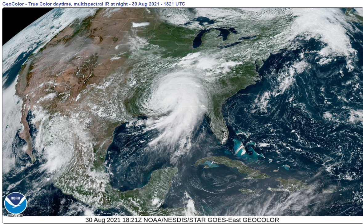
Ida has been downgraded to a tropical storm, but its impact is far from over. A swath of significant rain will fall during the next 72 hours all along its post-landfall storm track from the southern states to the Northeast US. Image courtesy NOAA/NESDIS/STAR
Overview
Hurricane Ida came ashore on Sunday in southern Louisiana as a strong category 4 storm following rapid intensification in the prior 24 hour period. Substantial rain fell yesterday and last night in the Gulf coastal region and damaging wind gusts knocked out power for over a million people as of earlier today including all of the city of New Orleans. Ida has been downgraded to a tropical storm, but its impact is far from over.
A major rain event associated with the remnants of Ida is coming first to the Tennessee and Ohio Valleys and then to the Mid-Atlantic region and Northeast US from later Wednesday into early Thursday. In fact, there will be a tendency for the tropical system to be “re-invigorated” in the Mid-Atlantic region as it interacts with an upper-level jet and a stalled-out frontal boundary zone. A swath of significant rainfall amounts of up to several inches will take place during the next 72 hours all along the post-landfall track of Ida extending from the southern states to the Northeast US and flooding will be a big concern all along the path. In addition to the heavy rain threat, severe weather will be on the table including the possibility of tornadic activity on the eastern side of the storm track.
Significant rain will fall during the next 72 hours along the path of Tropical Storm Ida with several inches possible all the way up to the Northeast US. Map courtesy NOAA
Details
Rapid intensification this weekend raised Ida from a category 1 hurricane on Saturday to a strong category 4 on Sunday before it made landfall in southern Louisiana during the mid-day hours. Hurricane Ida had been moving in a pretty constant northwesterly direction during the weekend with a consistent motion of about 15 mph or so, but since then it has slowed down some and has shifted to a general northerly direction. As such, it continues to produce substantial rain and wind at mid-day in the Deep South adding to the flooding problems down there and is not helping with the widespread power outage situation.
More than one million people are still without power at mid-day in the hard-hit states of Louisiana and Mississippi including in the city of New Orleans. Map courtesy poweroutage.us
At 2 PM, Tropical Storm Ida featured maximum sustained winds of 40 mph, central pressure of 997 millibars, and a movement to the north-northeast at 9 mph. A turn to the northeast is expected by later tonight and the remnants of Ida are quite likely to pick up some forward speed from tomorrow through mid-week. Heavy rain associated with TS Ida will push into the Tennessee and Ohio Valleys by later tonight/early Tuesday and it’ll continue there through tomorrow night. This is a part of the country that does not need more heavy rainfall as it has experienced some significant rainfall amounts in recent days and has already well-saturated grounds.
The trendline of hurricane strength for Louisiana has been rather neutral since the 1850’s. Plot courtesy Chris Martz, Twitter, NOAA
On Wednesday, the remnants of Ida will push into the Mid-Atlantic region and its associated rainfall shield will actually tend to become “re-invigorated” and likely broaden out as it encounters a stalled-out frontal boundary zone. In fact, this boundary zone will act as a very effective conduit for Ida’s deep tropical moisture field to ride along to the north and east - enhancing the chances for significant rainfall amounts in the DC-to-Philly-to-NYC corridor from later Wednesday into early Thursday. In addition to the boost to Ida from the stalled-out surface frontal boundary zone, an upper-level jet will help to rejuvenate the storm and its rainfall shield at mid-week in the Mid-Atlantic region as upward motion will be enhanced in the jet streak’s “right entrance” region.
12Z Euro model run holds firm with idea of a major rain event for the Mid-Atlantic region from later Wednesday into early Thursday associated with the remains of Ida. Forecast map for 2AM Thursday is courtesy ECMWF, WSI, Inc.
A general 2-5 inch rainfall is possible in the Mid-Atlantic region from later Wednesday into early Thursday and isolated higher amounts are even possible; especially, on the northwest side of Route I-95 in the DC-to-Philly-to-NYC corridor. Strong-to-severe thunderstorms can be mixed into the picture as well and - as is somewhat customary with tropical systems in the middle latitudes - tornadoes will be a threat on the eastern side of the storm track (i.e., along and to the south/east of Route I-95). Cool air for the beginning of September will follow the departure of the tropical storm with highs on Thursday, Friday and Saturday generally confined to the 70’s in the Mid-Atlantic region.
Stay tuned…this upcoming major rain event in the Mid-Atlantic region can certainly result in some serious flooding.
Meteorologist Paul Dorian
Peraton
peratonweather.com
Follow us on Facebook, Twitter, YouTube
Video discussion:


