10:00 AM | ***Significant rain and wind event from Florida-to-Maine next 24-48 hours as tropical moisture rides up through eastern states…cold pattern to follow across much of the nation***
Paul Dorian
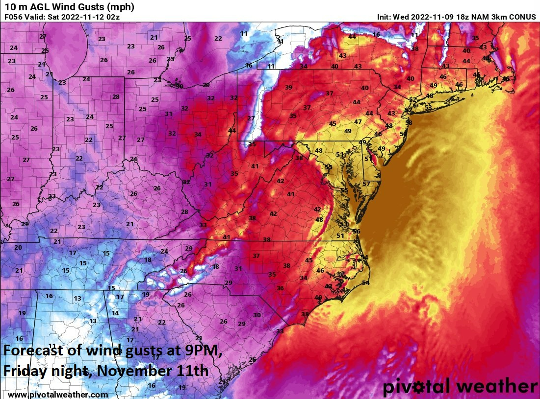
Winds can gust to 50 mph or so during the height of the upcoming storm at inland locations including in the big cities along the I-95 corridor. Map courtesy NOAA, Pivotal Weather
Overview
Nicole climbed to category 1 hurricane status late yesterday and came ashore in the overnight hours near Vero Beach in east-central Florida. After landfall, Nicole has weakened slightly back to tropical storm status and will become increasingly influenced by a deep upper-level trough over the north-central states that is contributing to blizzard-like conditions in the Upper Midwest/Northern Plains. The remains of Nicole will ride up along the spine of the Appalachian Mountains over the next 24-48 hours resulting in a significant rain and wind event all the way from Florida-to-Maine. On the east side of the expected storm track, severe weather will be a possibility including the threat of isolated tornadoes. The passage of the tropical storm will be part of an overall significant temperature pattern change in the central and eastern US that will bring much colder weather conditions for the remainder of November.
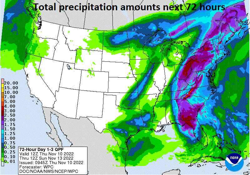
Significant rainfall amounts are expected over the next 24-48 hours all the way from Florida-to-Maine as the remnants of Nicole push to the north and northeast. Map courtesy NOAA/WPC
Significant rain and wind event from Florida-to-Maine
“Nicole” is a tropical storm this morning with sustained winds of around 60 mph after weakening some after landfall in the overnight hours in east-central Florida. Its current west-to-northwest movement will soon take a sharp turn to the north and then northeast as it becomes increasingly influenced by a deep upper-level trough over the north-central states. This deep upper-level trough is contributing to a power storm system over the Upper Midwest/Northern Plains and southwesterly winds on its front side will steer the remnants of Nicole to over the Appalachian Mountain chain during the next 24-48 hours. As a result, significant rain and wind will take place over the next 48 hours all the way from Florida-to-Maine with 50 mph wind gusts possible at inland locations at the height of the storm.
Severe weather is a threat later tomorrow and tomorrow night to the right of the expected storm track which would include the I-95 corridor and points to the east coast. Map courtesy NOAA/SPC
On the eastern side of the expected storm track (over the Appalachian Mountains), the atmosphere will become quite unstable with strong wind shear. As a result, the chance for severe thunderstorm activity will be on the increase later tomorrow and tomorrow night in the coastal plain region from the I-95 corridor to all coastal locations. As is the case with many northeastward-moving tropical systems over land, areas to the right of the storm track may also experience isolated tornadoes as well.
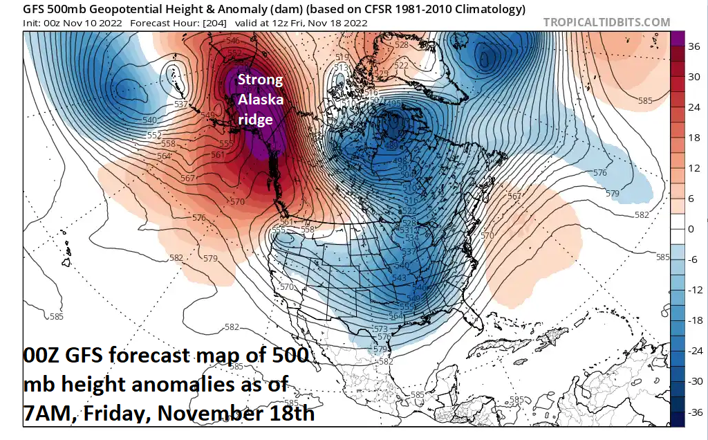
The exit of Nicole early this weekend will set off a pattern change that will bring much colder conditions to the central and eastern US in coming weeks. Maps courtesy NOAA, tropicaltidbits.com
Temperature pattern to change to much colder for the central and eastern US
The overall weather pattern has been very warm across the eastern states in recent days with spells of cold weather in the western US. In fact, temperatures earlier this week climbed well up into the 70’s in many parts of the Mid-Atlantic region and Northeast US challenging records in some spots. After Nicole exits out to the open waters of the western Atlantic early this weekend, the wind flow aloft will change to allow for the intrusion of cold air masses into the central and eastern states likely through the second half of the month of November. These air masses have been bottled up in the western US and Canada in recent weeks, but will now be able to penetrate much farther to the south and east.
A cold pattern will follow the exit of Nicole in the central and eastern states and a big contributing factor will be a strong upper-level ridge of high pressure that forms over Alaska. This strong ridge combined with upper-level trough in the central US/Canada will allow for the penetration of cold air masses into the central and eastern states in coming days. Map courtesy NOAA, tropicaltidbits.com
Temperatures are going to drop noticeably on Saturday night as the colder air begins to filter into the Mid-Atlantic/Northeast US and near or below freezing temperatures are likely by early Monday morning - even in the urbans areas along the I-95 corridor. Looking ahead, there may be the threat of snow later next week in parts of the eastern US as moisture pushes northward from the southern states and right into the cold air mass that will be entrenched across the northeastern states.
Meteorologist Paul Dorian
Arcfield
arcfieldweather.com
Follow us on Facebook, Twitter, YouTube
Video discussion:


