
12:45 PM | ****Nationwide cold pattern follows weekend exit of tropical storm…snow threat for the interior, higher elevation Mid-Atlantic/Northeast US…signs of longer-term cold pattern****
Paul Dorian

A powerful ridge will develop over Alaska during the next few days allowing for a cross-polar flow of very cold air into the central and eastern US. Map courtesy NOAA, tropicaltidbits.com
Overview
At the same time Tropical Storm Nicole was pounding Florida on Friday with rain and wind, a blizzard was raging in the Northern Plains where two feet of snow piled up in such places as Bismarck, North Dakota. That late week cold air mass situated in the Northern Plains subsequently made its way into the northeastern US following the departure of Nicole to the open waters of the Atlantic Ocean. The exit of Nicole helped to bring about a change to the overall upper air wind pattern across North America. In fact, not only has the eastern US chilled down during the past 24 hours, virtually the entire nation is now featuring colder-than-normal temperatures and will likely do so right through the weekend. By the end of the week, many low temperature records will have been broken; especially, across the center part of the nation and every state in the Lower 48 can experience below-freezing temperatures.
In terms of snow potential, a coastal low will intensify by tomorrow night just off the Mid-Atlantic coastline resulting in a cold, soaking rain in the immediate I-95 corridor and to coastal sections, but the first accumulating snowfall of the season is likely in many of the interior, higher elevation locations across the northeastern states. The chill may ease up for awhile later next week, but there are signs for a resumption of the cold pattern going into late November and December.

An impressive characteristic of this week’s cold wave is that it will virtually extend from coast-to-coast. The central US might very well experience record-breaking cold later this week in many spots. Map courtesy NOAA, tropicaltidbits.com
Near term outlook for a cold pattern
The first twelve days of November saw temperatures average as high as 11 degrees above-normal in places like Philly, New York City and Washington, D.C., but a switch to the overall upper-level wind flow has opened the flood gates for cold air to pour into the eastern US and it will stick around right into at least the upcoming weekend. Following the departure of Tropical Storm Nicole, upper-level ridging of high pressure has developed over Alaska/western Canada and it will intensify significantly in coming days. At the same time, an upper-level trough of low pressure will intensify over central parts of Canada and the US and the combination of the two systems will allow for multiple cold air masses to drop south and east from western Canada into the central and eastern US. An impressive characteristic of this change to a colder-than-normal weather pattern is that it virtually extends from coast-to-coast and will continue to so for several days. A reinforcing shot of cold air later this week will likely result in record-breaking cold across many spots in the central part of the nation.

A teleconnection known as the EPO has dropped into negative territory which is often indicative of a colder pattern for the central and eastern US as ridging forms over Alaska. In this instance, the EPO will plunge into “off-the-charts” negative territory and the Alaska ridge will intensify significantly later this week. Data courtesy ECMWF, Weather Bell Analytics.
One of the signals in recent weeks that suggested a change to cold was on its way after a warm start to the month came from a teleconnection index known as the East Pacific Oscillation or EPO. This index was predicted to drop from positive-to-negative this month and that often foretells the development of strong upper-level ridging over Alaska and a change to colder weather for the central and eastern US. In fact, not only has the EPO index dropped into negative territory, but it will actually plunge into “off-the-charts” negative territory by week’s end (perhaps record low values for November) and the ridging over Alaska will intensify significantly.

Another teleconnection index known as the Madden-Julian-Oscillation or MJO will shift into cold phases (7 and perhaps 8) later this month and December which often foretells a colder-than-normal weather pattern for the central and eastern US. Map courtesy NOAA
Signals of a cold pattern in the longer term
While this week’s chill is likely to ease later this month, there are signals suggesting that a cold pattern will resume by December for the central and eastern US. Another teleconnection index that we follow here at arcfieldweather.com is known as the Madden-Julian-Oscillation or MJO which tracks a tropical disturbance that traverses the globe on a repeating basis. This index value is tracked by meteorologists on a diagram that displays different phases from 1-8 with the MJO traveling through these in a counterclockwise fashion. The location of the MJO in any of the different phases can be well correlated with certain types of temperature and precipitation patterns around the world depending on the time of year.
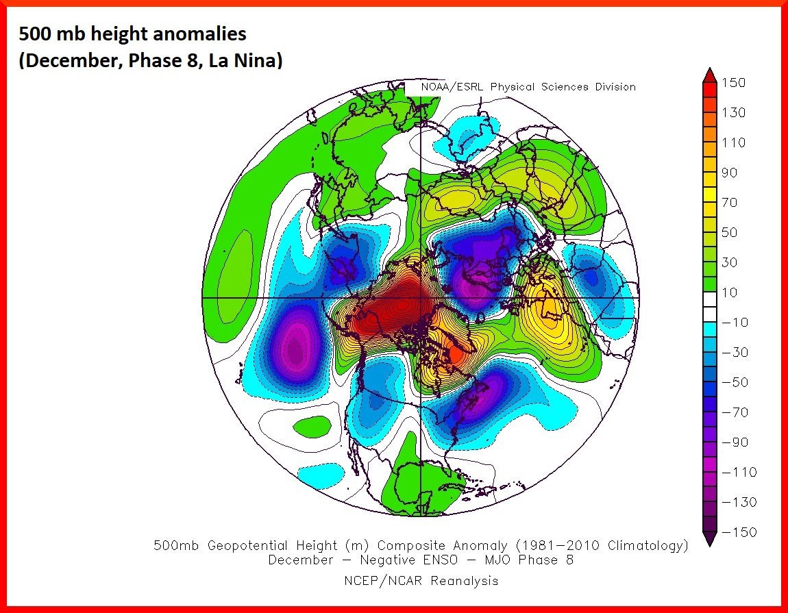
In December of La Nina winters (which we are experiencing), an MJO that shifts into phase 8 is usually associated with strong ridging over Alaska and upper-level low over the Northeast US…a cold pattern for the central and eastern US. Map courtesy NOAA/NCEP, Wx Risk
The MJO is now forecasted to push into phase 7 later this month and perhaps into phase 8 thereafter which is a trend we’ll closely monitor in coming days. A push by the MJO index into phases 7 and 8 this time of year is often correlated with colder-than-normal weather across the central and eastern US. Indeed, when the MJO pushes into phase 8 during the month of December in a La Nina winter (as we are experiencing), the result is often an upper-level low situated over the northeastern states and a strong ridge over Alaska…both of which are favorable for colder-than-normal weather in the Mid-Atlantic/Northeast US.
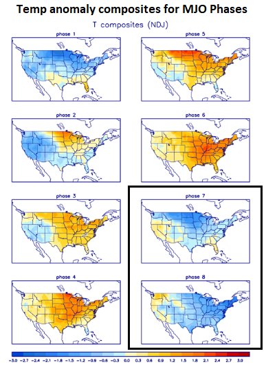
If the MJO shifts into phase 7 and/or 8 this time of year (lower, right boxed region), the temperature pattern usually is colder-than-normal for the central and eastern US. Data courtesy NOAA
Near-term snow threat for the interior, higher elevation locations
Now that the cold air has arrived in the Mid-Atlantic/Northeast US, the next question is “are there any prospects for snow?”. A coastal low is going to intensify early tomorrow night just off the Mid-Atlantic coastline and precipitation will move into the Mid-Atlantic/Northeast US from southwest-to-northeast. It will likely not be cold enough for snow in the immediate I-95 corridor to coastal sections; however, snowflakes can certainly mix in at times across some of the far northern and western suburbs of the big cities (e.g., northern Chester County, Upper Bucks and Montgomery Counties in Southeastern PA). Farther to the north and west, accumulating snow is likely across interior, higher-elevation locations all the way from eastern West Virginia/far western Virginia to northern New England. In some spots in those interior, higher elevation locations, the first accumulating snow of the season can total several inches.

Interior, higher elevation locations from eastern West Virginia/far western Virginia to northern New England will likely receive some accumulating snow from later tomorrow into early Wednesday. Plot courtesy NOAA (12Z NAM), tropicaltidbits.com
After the departure on Wednesday of this coastal low pressure system, the overall cold weather pattern will not only continue into the second half of the week, but it’ll actually intensify with an even greater departure from normal in the temperature department and many low temperature records can be broken. Later this week and into the upcoming weekend, there can be a major outbreak of “lake effect” snows just downstream of the still relatively-warm Great Lakes. As an example, Buffalo, New York - sandwiched between Lake Erie and Lake Ontario - has a chance to get walloped by “lake effect” snows from later Thursday into the early part of the weekend. Finally, there will be another wave of energy dropping far to the south later this weekend, but it is too early to say if this next system can push northeastward from the Gulf of Mexico and into the Mid-Atlantic/Northeast US.
Meteorologist Paul Dorian
Arcfield
arcfieldweather.com
Follow us on Facebook, Twitter, YouTube
Video discussion: