
2:00 PM | ***Coast-to-coast cold continues through the weekend…numerous low temperature records on the way…snow today interior Mid-Atl./NE US…intense Great Lakes snow event on the way***
Paul Dorian
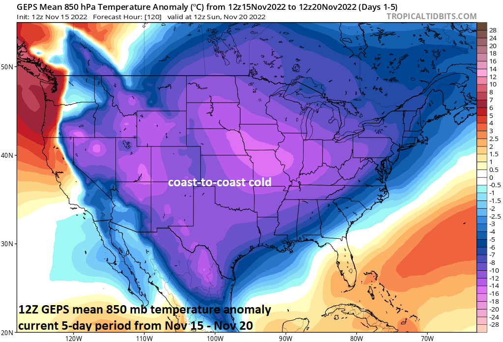
The unusual early season widespread cold across the US will persist right through the upcoming weekend. Numerous low temperature records are likely to be set during the next few days; especially, in the central states where temperatures could drop to as much as thirty degrees below normal for mid-November. Map courtesy Canadian Met Centre, tropicaltidbits.com
Overview
This “middle” week of the month of November could turn out to be one of the coldest in a long, long time for the nation as a whole with virtually coast-to-coast colder-than-normal weather conditions. There was a smattering of low temperature records set this morning across the central and western US and numerous records are likely to be set later this week and weekend; especially, across the central states where temperatures could drop to as much as thirty degrees below normal for this time of year.
In terms of snowfall in this unusual early season cold wave, it looks like the first widespread snow of the season will take place from later today into early Wednesday across interior, higher elevation sections of the Mid-Atlantic/Northeast US. Later this week, an intense Great Lakes snow event will kick into gear with paralyzing amounts of snow possible in some spots such as Buffalo and Watertown in western New York.

A smattering of record low temperatures were set this morning in the central and western US and this number will likely increase sharply in coming days. Map courtesy coolwx.com, NOAA
Coast-to-coast cold
The first couple of weeks of November saw temperatures average well above normal in much of the eastern half of the nation, but the overall weather pattern has changed significantly and virtually the entire nation is now experiencing below-normal temperatures with every state in the Lower 48 likely to experience some spots with below-freezing temperatures. There were a handful of near or record low temperature records set this morning across the central and western US and the trend for this will be sharply higher over the next few days. In fact, the next cold air mass to drop in the US from Canada will be colder than this current one relative-to-normal with some spots in the central US likely to be some thirty degrees below-normal later in the week. This next cold air mass will stick around right through the upcoming weekend making for one of the coldest mid-November weeks across the nation in many years.

The first widespread snow event of the season is in store later today and tonight across interior, higher elevation locations of the Mid-Atlantic/Northeast US. Map courtesy NOAA, tropicaltidbits.com
Snow in the Mid-Atlantic/Northeast US; intense Great Lakes snow event
Low pressure will develop along the Mid-Atlantic coastline by tonight and then will intensify as it pushes to the northeast in the overnight hours. A cold soaking rain will develop later today in the immediate I-95 corridor region from DC-to-Philly-to-NYC, but it’ll be cold enough for snow and sleet across many interior, higher elevation locations from eastern West Virginia/far western Virginia to northern New England.
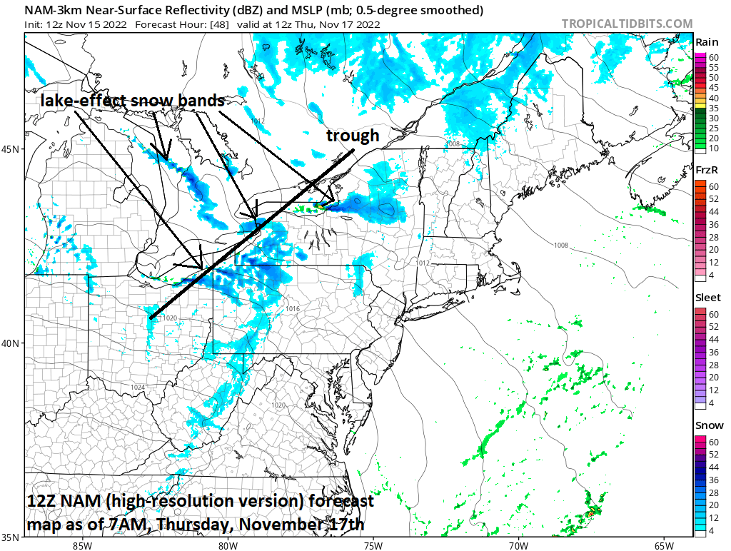
An intense Great Lakes snow event is likely later this week as a thermal trough forms with very cold air pushing over the still relatively warm lake waters. This could result in several feet of snow for such places as Buffalo and Watertown in western New York where there can be an extended period of southwesterly winds supplying copious amounts of moisture from Lake Erie into these sites. Map courtesy NOAA, tropicaltidbits.com
Later this week, the setup will be just right in some downstream locations of the Great Lakes for an intense snow event as very cold air for this time of year will pour over the still relatively warm lake water. As an example, a thermal trough will likely develop over Lake Erie with nearly a 20 degree (C) difference between the lake surface and air flowing in the lower part of the atmosphere. This action will destabilize the atmosphere significantly and it is likely to become a long duration event from Wednesday night/Thursday into the upcoming weekend. It is always a difficult forecast to pin down the all-important exact wind direction, but there is the chance for an extended period of southwesterly winds near Buffalo and Watertown in western New York State which could potentially bring copious amounts of moisture off of Lake Erie into these locations - possibly resulting in several feet of snow and an early season crippling event.
Meteorologist Paul Dorian
Arcfield
arcfieldweather.com
Follow us on Facebook, Twitter, YouTube
Video discussion: