1:30 PM (Wed) - ***Nationwide cold wave continues with numerous low temperature records likely to be set…intense Great Lakes snow event on the way***
Paul Dorian
The “perfect” scenario for places like Buffalo and Watertown of western New York State to get pummeled by snow in a Great Lakes snow event is for an extended period with low-level W-SW winds - and this is on the table for these locations from later tomorrow into the weekend. Map courtesy NOAA, tropicaltidbits.com
Overview
Temperatures across the nation this morning averaged out to an impressive reading of nearly 12 degrees (F) below-normal for mid-November and no state in the Lower 48 escaped the colder-than-normal chill. The first widespread snow event of the season took place late yesterday in the interior, higher elevation locations of the Mid-Atlantic/Northeast US with half of foot of snow recorded in some areas. The next few days will feature a “Great Lakes snow-making machine” that will be turned on in full force and the result may be several feet of snow in some downstream locations such as Buffalo and Watertown in western New York. The nationwide cold will continue right through the upcoming weekend.
The nationwide temperature anomaly this morning was an impressive nearly 12 degrees (F) below the average for November 16th. The unusually widespread early season cold wave will continue across much of the nation through the upcoming weekend. Map courtesy NOAA, weathermodels.com (Dr. Ryan Maue, Twitter)
Coast-to-coast cold continues
The first couple of weeks of November saw temperatures average well above normal in much of the eastern half of the nation, but the overall weather pattern has certainly changed in a significant way. Virtually all the states in the Lower 48 experienced colder-than-normal chill this morning with the 10AM nationwide temperature anomaly registering at nearly 12 degrees (F) below the normal for the date. This early season chill down will continue through the weekend in most of the country as reinforcing cold air masses drop into the US from Canada. In fact, the next cold air outbreak will likely result in numerous low temperature records later this week; especially, across portions of the central US where temperatures could drop to as much as thirty degrees below normal for mid-November.
There was a smattering of near or record low temperatures set On Tuesday morning (left) and Wednesday morning (right). More numerous low temperature records are likely to be set later this week with the influx of an even colder air mass; especially, across the central states where temperatures could drop to nearly thirty degrees below normal. Maps courtesy coolwx.com, NOAA
First snow event on Tuesday in the interior Mid-Atlantic/Northeast US
Low pressure developed late yesterday near the Mid-Atlantic coastline and then intensified as it pushed to the northeast in the overnight hours. A cold soaking rain took place along the immediate I-95 corridor (although some flakes and ice pellets mixed in at times), but it turned out to be the first widespread snow event for many interior, higher elevation locations of the Mid-Atlantic/Northeast US with half of foot measured in many spots.
The interior, higher elevation sections of the Mid-Atlantic/Northeast US experienced their first widespread snow event of the season late yesterday and last night with many spots receiving as much as half a foot of snow. Map courtesy NOAA
Intense Great Lakes snow event on the way
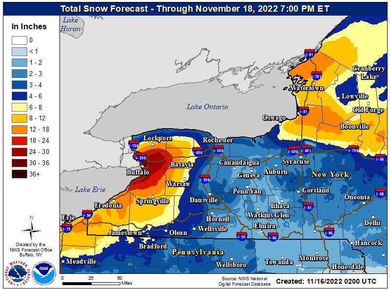
Beginning late tomorrow and continuing through much of the weekend, the atmospheric setup will be just right in some downstream locations of the Great Lakes for an intense and potentially crippling snow event. Very cold air for this time of year will persistently pour over the still relatively warm waters of the Great Lakes and this action will destabilize the atmosphere in what is likely to become a long duration event from later tomorrow through much of the weekend.
The potential exists for extreme snowfall amounts in coming days of up to several feet in places like Buffalo and Watertown in western New York State. Map courtesy NOAA
It is always a difficult forecast to pin down the all-important exact wind flow in this kind of localized (“mesoscale”) weather event, but it appears there will be an extended period with low-level W-SW winds blowing across Lake Erie and Lake Ontario. This is the perfect wind trajectory for places like Buffalo and Watertown to get pummeled with heavy snow bands as this direction allows the air to flow over the lake of interest (Erie or Ontario) for the longest period of time as a result of their particular geographical orientation. Given this expected wind flow scenario, copious amounts of moisture will push into Buffalo (from Lake Erie) and Watertown (from Lake Ontario) in the form of intense snow banding. This kind of event has the potential of dumping several feet of snow in localized areas such as Buffalo and Watertown in western New York with incredible hourly snow rates possible…a potential paralyzing early season snow event.
Meteorologist Paul Dorian
Arcfield
arcfieldweather.com
Follow us on Facebook, Twitter, YouTube
Video discussion (from Tuesday morning):


