
***A look ahead to the month of December…numerous signs point to the re-establishment of a colder-than-normal weather pattern***
Paul Dorian

Trends in teleconnection indices known as the East Pacific Oscillation (EPO) and North Atlantic Oscillation (NAO) suggest upper-level ridging may form near Alaska and also near Greenland/Iceland in the early part of December. This kind of pattern aloft usually is conducive to colder-than-normal conditions across the central and eastern US. Map courtesy NOAA, Weather Bell Analytics
Overview
After a very mild start to the month of November in much of the eastern half of the nation, the weather has been primarily colder-than-normal during the last ten days or so. In fact, numerous low temperature records were set last week and earlier this week in what was an unusually widespread and severe cold air outbreak across much of the nation. Looking ahead, it looks like it’ll be seasonal or even warmer-than-normal in the central and eastern in coming days as we close out the month of November. Numerous signs, however, point to the return of a colder-than-normal weather pattern during the month of December. probably with sustained cold reaching the eastern US after the 7th or 8th.
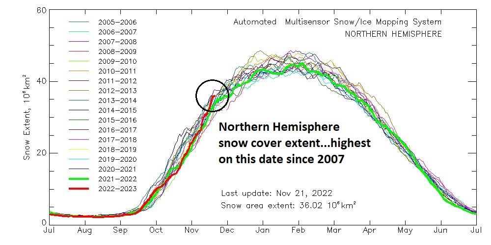
As of November 21st, snow cover extent across the northern hemisphere was at its highest level since 2007.
Discussion
The recent chill in the central and eastern US has eased just in time for the holiday and it looks to be close-to-normal temperature-wise in coming days or even slightly above-normal. As an example, high temperatures over the next several days are likely to fall in the 50’s in the DC-to-Philly-to-NYC corridor which is not too far off the normal for the latter part of November. Several signs, however, point to the possibility of the re-establishment of a colder-than-normal weather pattern in much of the central and eastern US as we proceed through the month of December which gets underway next Thursday.

The teleconnection index known as the East Pacific Oscillation or EPO is forecasted by the ECMWF Ensemble model to drop into “negative” territory in early December. This trend in the EPO is generally correlated with strong high pressure ridging to form near Alaska which, in turn, can help to push cold air masses from Canada into the central and eastern US. Plot courtesy ECMWF, Weather Bell Analytics
Teleconnection indices (EPO, NAO, MJO), upper-level height anomalies, NH snow cover extent
Trends in teleconnection indices are closely watched this time of year as they can provide clues regarding upcoming weather conditions in the central and eastern US. Three such indices that we closely monitor here at arcfieldweather.com include the East Pacific Oscillation (EPO), North Atlantic Oscillation (NAO) and the Madden-Julian Oscillation (MJO). The EPO index gives us an idea as to the overall temperature, wind and precipitation patterns across the eastern Pacific Ocean. The NAO index gives us a clue as to these same overall weather patterns over the North Atlantic Ocean. Meanwhile, the MJO index tracks a tropical disturbance that traverses the tropics on a repeating basis. All of these teleconnection indices are suggesting the central and eastern US may feature a re-establishment of a colder-than-normal weather pattern during the month of December after a near-term milder stretch of weather.

The teleconnection index known as the North Atlantic Oscillation or NAO is forecasted by the ECMWF Ensemble model to drop into “negative” territory in early December. This trend in the NAO is generally correlated with strong high pressure ridging to form near Greenland/Iceland which, in turn, can help to push cold air masses from Canada into the central and eastern US. Plot courtesy ECMWF, Weather Bell Analytics
In the case of a “negative” EPO, the effect is usually strong high pressure ridging that pops up near or over Alaska and this, in turn, enhances the possibility that the overall upper-level wind flow will have the ability to drop cold air masses from the polar region south and east through Canada and into the central and eastern US. In the case of the “negative” NAO, the effect is usually strong high pressure ridging that forms over Greenland, Iceland and/or northeastern Canada and this, in turn, also promotes the idea that cold air masses can work their way from way up in Canada to the central and eastern states. Given the expectation of the EPO and NAO teleconnection indices to drop into “negative” territory, it is not too surprising to see several computer model forecast maps depicting the formation of strong upper-level (at 500 millibars) ridging during early December in these two particular locations of near/over Alaska and near/over Greenland, Iceland and northeastern Canada.

Another teleconnection index known as the Madden-Julian-Oscillation or MJO will likely shift into cold phases 7 and 8 later this month and into early December which often foretells a colder-than-normal weather pattern for the central and eastern US. Map courtesy ECMWF, NOAA
The MJO index value is tracked by meteorologists on a diagram that displays different phases from 1-8 with the MJO traveling through these in a counterclockwise fashion. The location of the MJO in any of the different phases can be well correlated with certain types of temperature, wind and precipitation patterns around the world depending on the time of year. The MJO is currently forecasted to push into phase 7 later this month and then likely into phase 8 during early December which is a trend we’ll closely monitor in coming days. A push by the MJO index into phases 7 and 8 this time of year is often correlated with colder-than-normal weather across the central and eastern US.
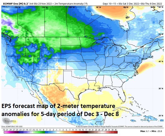
Euro Ensemble 2-meter temperature anomaly forecast map for the time period of December 3rd - December 8th suggests colder-than-normal conditions across much of the nation. Map courtesy ECMWF, Weather Bell Analytics
One additional factor that is worth mentioning in a look ahead to December is the extent of snow cover that currently exists across the northern hemisphere. It happens to be at its highest level on this particular date (11/21) since the year 2007. A higher-than-normal snow cover extent across the northern hemisphere is generally a favorable factor for the build-up of deeper and more widespread cold air masses in the source region for the central and eastern US.

Euro Weeklies 2-meter temperature forecast map for the time period of December 14th - December 21st suggests colder-than-normal conditions across much of the nation. Map courtesy ECMWF, Weather Bell Analytics
We’ll continue to monitor all of these signs in coming days to better determine if, in fact, a colder-than-normal weather pattern will get re-established in the central and eastern US following the milder stretch that is anticipated in the near-term.
Meteorologist Paul Dorian
Arcfield
arcfieldweather.com
Follow us on Facebook, Twitter, YouTube
Video discussion: