
12:00 PM (Tues) | ***Severe weather threat today Lower MS/TN Valleys…50 mph wind gusts later Wed./Wed. night Mid-Atl./NE US…numerous signs continue to point to a cold December pattern***
Paul Dorian

A powerful low-level jet will translate into the Mid-Atlantic/Northeast US by mid-day Wednesday and the result may be 50+ mph wind gusts from later tomorrow into tomorrow night in the DC-to-Philly-to-NYC corridor. Map courtesy NOAA, tropicaltidbits.com
Overview
A potent cold front will wreak havoc across the eastern half of the nation from today into Thursday with a severe weather threat later today into tonight across the Lower Mississippi and Tennessee Valleys - to include the possibility of isolated tornadoes - and potential damaging wind gusts from later tomorrow into tomorrow night in the Mid-Atlantic/Northeast US. An intensifying low pressure system will help to strengthen a low-level jet on Tuesday afternoon and evening and this wind field will translate into the Mid-Atlantic/Northeast US later tomorrow/tomorrow night and 50+ mph wind gusts will be on the table.
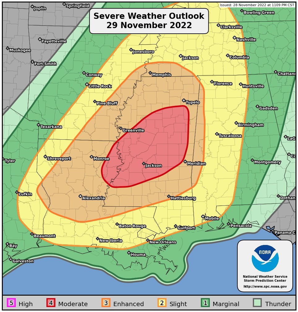
The focus of the severe weather threat later today and tonight will be in Mississippi, but surrounding states of Arkansas, Tennessee, Louisiana and Alabama will be under the gun as well. Map courtesy NOAA/SPC
Short-term outlook with a severe weather threat to include isolated tornadoes
A late season severe weather threat is in the cards for later today and tonight across the Lower Mississippi and Tennessee Valleys as a potent surface cold front pushes eastward associated with an intensifying surface low pressure system that heads towards the Great Lakes. The atmosphere is already moistening up in the Deep South with a low-level flow of air off of the Gulf of Mexico and it will become increasingly unstable later in the day throughout the Lower Mississippi and Tennessee Valleys. The chance for severe weather will increase to include possible damaging wind gusts, large hail and even isolated tornadoes in this part of the nation. The front finally pushes to the Southeast US coastline by mid-day Wednesday ending the severe weather threat there at that time.
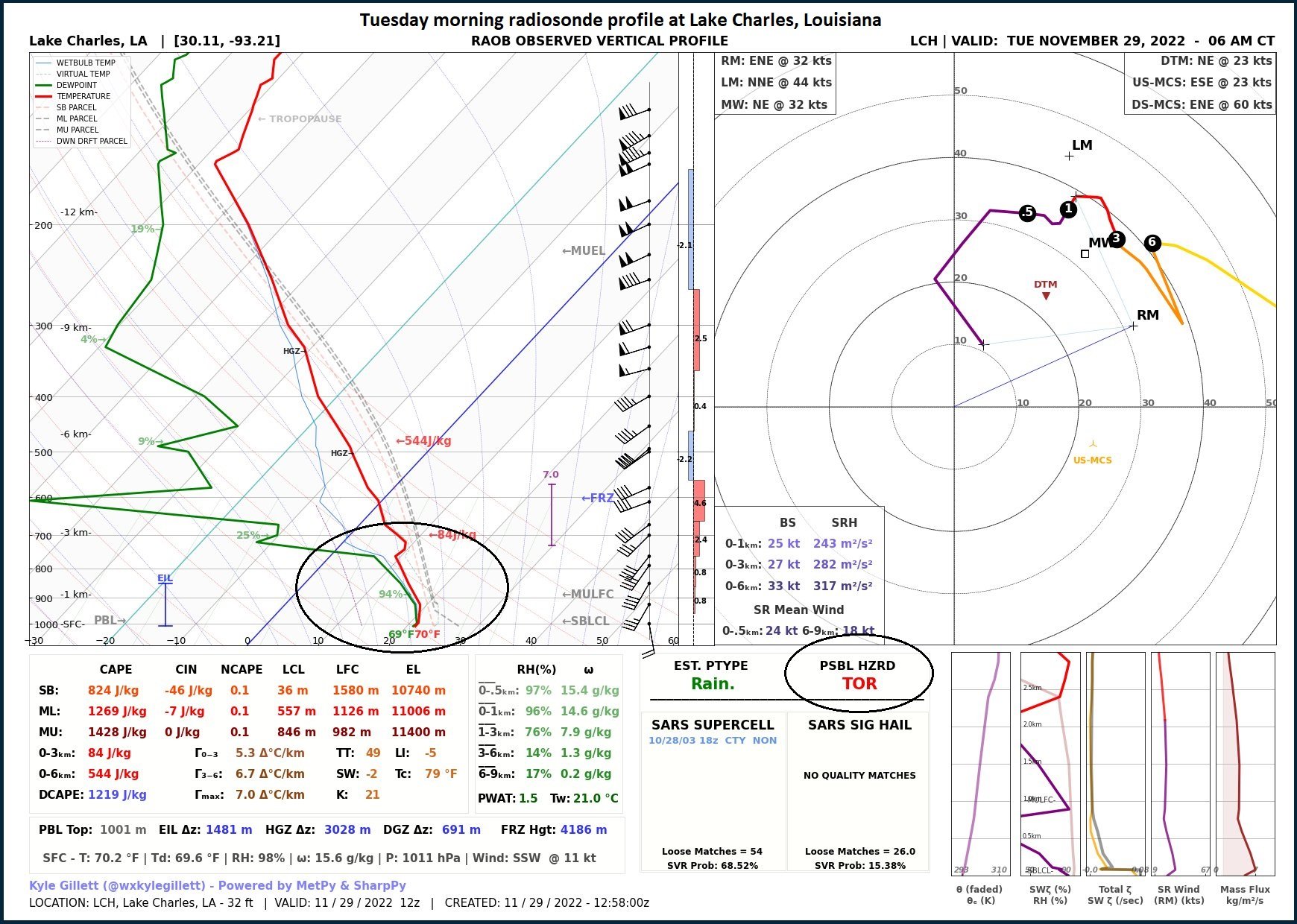
The Tuesday morning radiosonde profile (left) at Lake Charles, Louisiana and its associated metadata raise some “red flags” for the weather outlook for later today. First, low-level moisture has increased noticeably (circled area on left plot) and second, the atmospheric instability is quite impressive which raises “tornado” as a possible hazard (right circle). Plot courtesy NOAA
On Wednesday, the potent surface cold front will cross the Ohio Valley and winds ahead of it will increase noticeably in the Mid-Atlantic region and Northeast US. In fact, SW winds can gust to 50+ mph later Wednesday into Wednesday night as a powerful low-level jet pushes northeastward with the advancing surface cold front. Temperatures can jump to near 60 degrees in the DC-to-Philly-to-NYC corridor on Wednesday afternoon with numerous showers likely to go along with the expected powerful winds.

Severe thunderstorms are likely later today and early tonight across the Tennessee and Lower Mississippi Valleys and isolated tornadoes are on the table. Map courtesy NOAA, tropicaltidbits.com
Following the passage of the front early tomorrow night in the Mid-Atlantic/Northeast US, winds will shift to a northwesterly direction and remain quite strong on Thursday with gusts likely to 40+ mph. One note of caution…in the immediate hour or two following the frontal passage, atmospheric pressures will jump rapidly and this could result in some excessive wind gusts for a short period of time. It’ll become noticeably colder following the frontal passage in the DC-to-Philly-to-NYC corridor with highs likely in the 40-45 degree range on Thursday afternoon following the near 60 degrees expected tomorrow afternoon. It remains quite chilly and dry on Friday and then milder weather returns on Saturday with a chance of showers with the next frontal system.
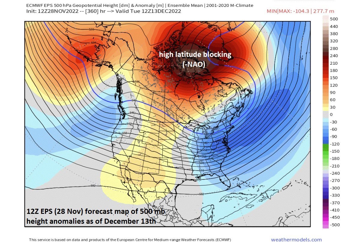
The ensemble run of the 12Z Euro is forecasting a 500 mb height pattern that features much higher heights compared to normal by mid-December over Greenland and northeastern Canada (i.e. a negative NAO “high-latitude blocking” pattern). In addition, there will be an upper-level trough over the eastern US which actually retrogrades westward from the western Atlantic Ocean. All in all, a cold and potentially active weather pattern may be shaping up for the eastern by mid-December. Map courtesy ECMWF, weathermodels,com
Longer-term outlook with continuing signs of a cold pattern in December
Numerous signs continue to point to a colder-than-normal weather pattern during the month of December across much of the nation. The sustained cold weather pattern will first develop across the north-central states and then likely spread the Mid-Atlantic/NE US after the 7th or 8th of December. Three teleconnection indices that suggest favorable conditions will develop for colder-than-normal weather across much of the nation in December include the North Atlantic Oscillation (NAO), Arctic Oscillation (AO) and the Madden-Julian Oscillation (MJO). The NAO and AO indices provide us with clues as to what the overall temperature and pressure patterns are over the North Atlantic Ocean and Arctic regions. The MJO index helps meteorologists track a tropical disturbance that traverses the tropics on a repeating basis. All of these teleconnection indices are suggesting the central and eastern US may feature a re-establishment of a colder-than-normal weather pattern during the month of December.
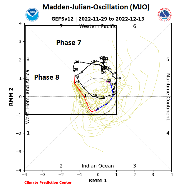
The MJO is currently pushing through “Phase 7” and headed towards “Phase 8” - both of these are historically correlated with colder-than-normal weather conditions across much of the nation during this time of year. Map courtesy NOAA
The NAO and AO will be dropping well into negative territory during the next couple of weeks which is more favorable for cold air masses to make their way into the central and eastern US from northern Canada. In fact, the drop in the NAO that is expected during the first half of December is very impressive from a historical basis with potentially the lowest value in many years for the month of December and the surface atmospheric pressure that is modeled for Greenland may be near the all-time high ever recorded.

The North Atlantic Oscillation or NAO is forecasted to drop well into “negative” territory during the month of December and historically-speaking, a negative NAO in December is pretty well correlated with colder-than-normal conditions across the eastern two-thirds of the nation as shown by this temperature anomaly plot. Map courtesy BAMWX (Twitter), NOAA
The MJO index value is tracked by meteorologists on a diagram that displays different phases from 1-8 with the MJO traveling through these in a counterclockwise fashion. The location of the MJO in any of the different phases has been well connected to certain types of temperature, wind and precipitation patterns around the world depending on the time of year. The MJO is currently rotating through “Phase 7” and will head into “Phase 8” during early December. A push by the MJO index into phases 7 and 8 this time of year is often correlated with colder-than-normal weather across the central and eastern US.
Meteorologist Paul Dorian
Arcfield
arcfieldweather.com
Follow us on Facebook, Twitter, YouTube
Extended video discussion found here: https://arcfieldweather.com/videos