9:00 AM | ***Tropical Storm Nicole to reach Florida later in the week…possibly reaches hurricane status…moisture to ride up along east coast…part of transition to much colder pattern***
Paul Dorian
Tropical Storm Nicole may reach Florida’s east coast by early Thursday and it can climb to category 1 hurricane status before making landfall. Map courtesy Canadian Met Centre, tropicaltidbits.com
Overview
The tropical scene is still active and kicking in the Atlantic Basin and an area of disturbed weather in recent days has organized into Tropical Storm Nicole over the southwestern Atlantic Ocean. This system is likely to reach Florida later this week and there is a chance that it reaches category 1 hurricane status before making landfall. The moisture associated with Nicole is likely to then ride up along the eastern seaboard at week’s end. The passage of the tropical system will be part of an overall significant temperature pattern change across the nation that will bring much colder weather conditions to the central and eastern US.
A significant rain event is possible from Florida to the northeastern states later this week and early weekend as Nicole’s tropical moisture field could ride right up along the east coast. Map courtesy NOAA
Tropical Storm Nicole to impact Florida and moisture can ride up along east coast
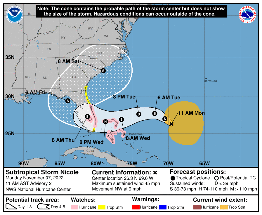
“Nicole” is a tropical storm over the southwestern Atlantic Ocean with sustained winds of 45 mph and is moving NNW at 14 mph. Indications are that Nicole will tend to slow down later today and shift to a northwestward direction followed by a turn to the west as an upper-level ridge forms off the coastline. On this expected track, Tropical Storm Nicole is liable to reach Florida’s east coast around Thursday morning - likely between Miami and Cape Canaveral - and it can reach hurricane category 1 status before it makes landfall.
The official storm track by NOAA’s National Hurricane Center is depicted on this map. Nicole could reach hurricane status before making landfall along Florida’s east coast on Wednesday night or Thursday. Map courtesy NOAA/NHC
Once Nicole reaches Florida, it’ll become increasingly influenced by a large upper-level trough traveling eastward across the country and the result will be a sharp turn to the north and northeast by the tropical system allowing for its moisture field to ride up along the eastern seaboard - and a significant rain event is possible from Florida to northern New England.
The next few days will average warmer-than-normal across the eastern half of the nation and colder weather in much of the western US. Map courtesy NOAA, tropicaltidbits.com
Temperature pattern to change to much colder for central/eastern US
The overall weather pattern has been very warm across the eastern states in recent days and today is very likely to be the warmest day until next spring with many spots reaching well up into the 70’s. Meanwhile, there have numerous spells of colder-than-normal weather in the western US in recent days. The clash between the cold air to the west and warm air to the east actually contributed to a severe weather outbreak at the end of last week with numerous tornadoes reported in the “battle zone” region of the south-central US.
A major temperature pattern change will develop across the nation following the exit of “Nicole” to the Atlantic Ocean this weekend. Much colder conditions will push into the central and eastern US by the end of the upcoming weekend following several days of warmer-than-normal weather. Map courtesy NOAA, tropicaltidbits.com
In a look ahead, it is not unusual this time of year for the passage of a tropical system to result in a major temperature pattern change across the nation and indeed it appears as though the central and eastern states will turn much colder beginning later this weekend. Cold air masses that have been bottled up across the western parts of Canada and the US in recent days, but soon will be able to flood into the central and eastern states as the overall wind flow aloft will change following the exit of Tropical Storm Nicole to the Atlantic Ocean. Much colder conditions are likely here in the Mid-Atlantic region by Sunday and Monday of next week with a possible freeze on Sunday night and the noticeably colder weather pattern looks like it will continue as we progress right through the second half of November.
Meteorologist Paul Dorian
Arcfield
arcfieldweather.com
Follow us on Facebook, Twitter, YouTube
Video discussion:


