
1:00 PM | ***Wintry mix at onset of late week storm system in Mid-Atlantic region…very cold pattern now across much of Europe/Asia…sets up across US later next week…active pattern continues***
Paul Dorian
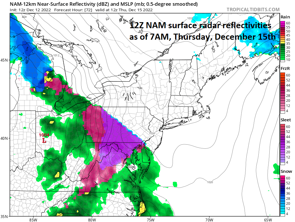
A wintry mix can move into the Mid-Atlantic region by early Thursday as a large precipitation field heads this way associated with a strong storm system that will produce blizzard conditions in the Northern Plains/Upper Midwest and severe weather down in the southern US. Map courtesy NOAA, tropicaltidbits.com
Overview
The overall weather pattern has become quite active and the latest storm system will wreak havoc across much of the nation during the next few days. In fact, this system has already contributed to several feet of snow in the Sierra Nevada and southern Cascades out west and blizzard conditions will develop on Tuesday across the northern Rocky Mountain states. By tomorrow night and Wednesday, this storm system will bring blizzard conditions to the and Northern Plains and Upper Midwest.
At the same time, the warm sector of this storm will likely feature some severe weather from later tomorrow into Wednesday across the Lower Mississippi and Tennessee Valleys. On Thursday, the precipitation field from this impactful storm system will reach the Mid-Atlantic region and the onset is likely to feature a wintry mix - even into the I-95 corridor before an eventual changeover to plain rain.
Looking ahead, a very cold pattern is destined to develop across the central and eastern US later next week. Arctic cold has already become well established across much of Europe and Asia – often a foreshadowing of conditions to come in the US. The cold pattern will remain quite active as well increasing the chances for a White Christmas in much of the northern US.
This week’s impactful storm system
Over the weekend, several feet of snow fell across the Sierra Nevada and southern Cascades in the western part of the nation and this same storm system will wreak havoc farther east on Tuesday and Tuesday night from the Northern Rocky Mountain states to the Northern Plains. Blizzard conditions will first break out on Tuesday across the Northern Rockies impacting such states as Montana and Wyoming and then they’ll develop in the Northern Plains/Upper Midwest by tomorrow night and Wednesday. Heavy snow and strong winds will spread from the Rocky Mountain States to the Dakotas/Nebraska and ultimately into Minnesota and Upper Wisconsin. The surface low pressure system will grind to a halt and begin to weaken as it reaches the Great Lakes thanks to strong high-latitude blocking in the atmosphere over Canada. This action will lead to re-development of surface low pressure near the Delmarva Peninsula later in the week which will then create a lot of problems for the Mid-Atlantic/Northeast US.
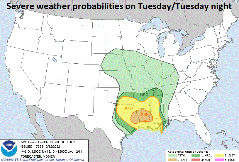
Severe weather can break out later tomorrow/tomorrow night in the Lower Mississippi and Tennessee Valleys. Map courtesy NOAA/SPC
Meanwhile, in the warm sector of the storm, warm and humid air will flow northward on Tuesday out of the Gulf of Mexico and into the Mississippi and Tennessee Valleys over the next 24-48 hours. With a cold air mass charging to the south and east, a clash zone will form and severe weather is likely to be the result across some of the southern US including the chance for isolated tornadoes.
The precipitation field associated with the weakening initial storm system and re-developing low will impact the Mid-Atlantic region by early Thursday. There is likely to be enough cold air around for a wintry mix to take place early Thursday at the onset of the event – even into the immediate DC-to-Philly-to-NYC corridor. In fact, small accumulations of snow and/or ice are possible early Thursday in this region before an ultimate changeover to plain rain. A changeover is likely as the a re-developing surface low will form near or over the Delmarva Peninsula and this positioning should allow for enough warming at lower levels of the atmosphere to generate a changeover to plain rain in the I-95 corridor to coastal sections. Significant accumulating snow, however, can develop from the intensifying coastal low across upstate PA and NY State during this late week event perhaps with some icing as well.
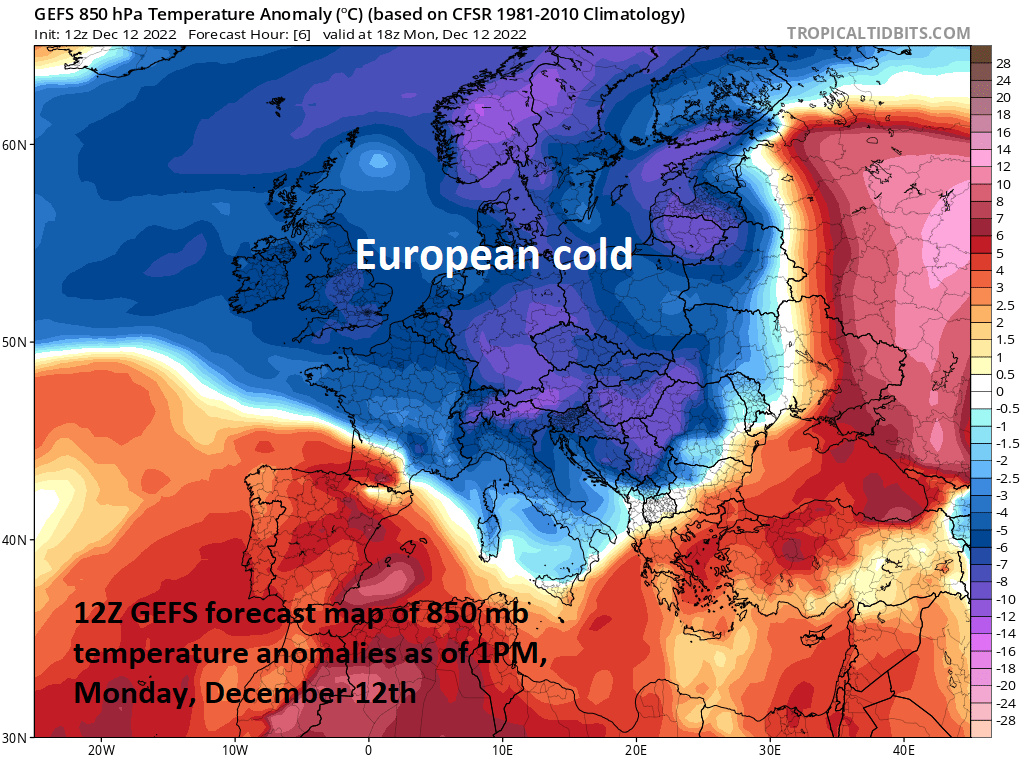
Arctic air currently grips much of the European continent from the UK to Scandinavia and extreme cold is being felt in much of Russia/Siberia as well. Map courtesy tropicaltidbits.com, NOAA
European/Asian cold…next week’s cold in the US
A large part of Europe from the UK to France/Germany to the Scandinavian countries is experiencing Arctic cold and heavy snow is falling in many places. The Arctic cold extends to Russia/Siberia as well with some parts of Siberia suffering through some extreme cold conditions and temperatures as low as minus 77 degrees (F) (in the icebox region of Oymyakon). Often this time of year, a cold pattern will become established over Europe/Asia before it does so in the US, and signs are pointing to the possibility for some very cold air to reach the central and eastern states later next week and perhaps sticking around through Christmas weekend.

The United Kingdom is under the deep freeze and snow has fallen in many places including in London, England…somewhat unusual for the first half of December. (Westminster Abbey)
“Cross-polar” flow will develop across the polar region later this week and this will likely bring a very cold blast of air into the US as we go through next week. The overall weather pattern should remain quite active as well next week and this will increase the chance for many in the northern US to experience a White Christmas, but more on those chances in coming days – a lot to go through before we get there.
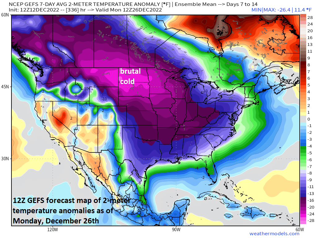
Very cold air could drop southeast later next week from northern Canada into the central and eastern US. This widespread cold air outbreak could last right through Christmas weekend with much colder-than-normal weather virtually from coast-to-coast. Map courtesy NOAA, weathermodels.com, BAMWX (Twitter)
Meteorologist Paul Dorian
Arcfield
arcfieldweather.com
Follow us on Facebook, Twitter, YouTube
Video discussion: