12:45 PM | *****Record-breaking Arctic outbreak next week and a very cold looking Christmas weekend……major storm may precede the Arctic blast…significant snow next 24 hours interior Northeast US*****
Paul Dorian

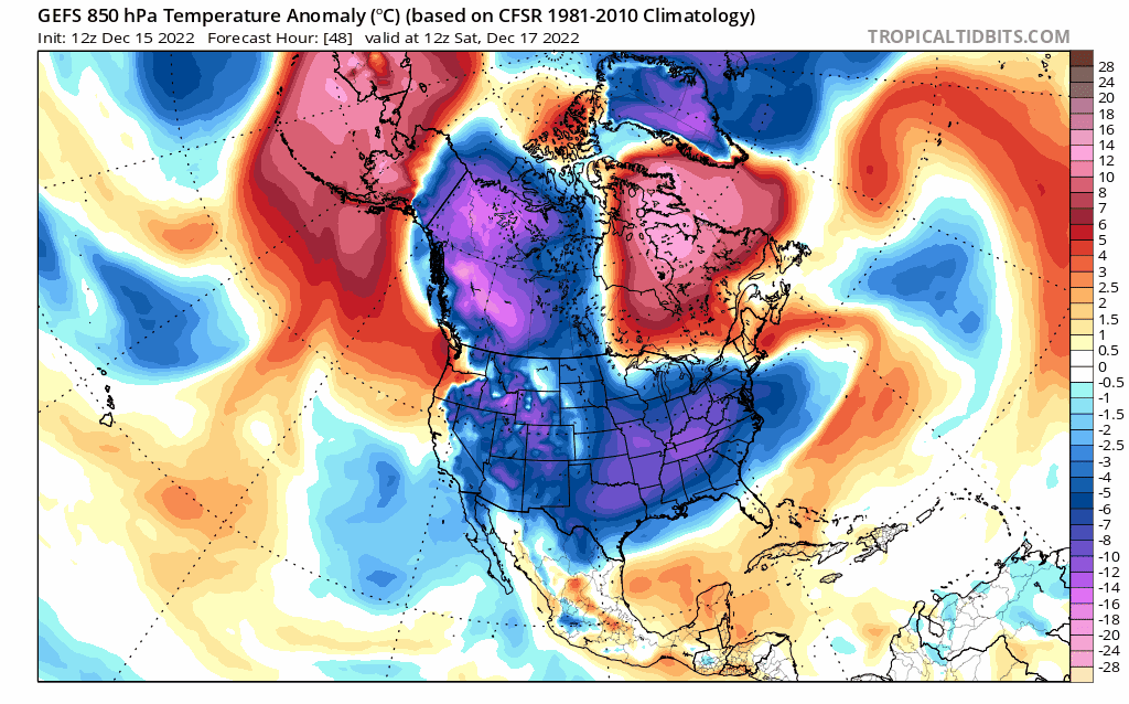
This loop of 850 mb temperature anomalies from the 12Z GEFS extends from this Saturday, December 17th to Christmas Eve, Saturday, December 24th and it suggest there will be a lot of much colder-than-normal weather for the US. A major Arctic air intrusion next week will slide south and east from the interior northwest/north-central states all the way to the Deep South and to the eastern seaboard. This upcoming cold will have staying power and Christmas Eve (Saturday) and Christmas Day (Sunday) may turn out to be the coldest in many years across much of the eastern half of the nation. Maps courtesy NOAA, tropicaltidbits.com
Overview
A record-breaking Arctic air outbreak will blast into the US next week. This frigid air mass will spread south and east next week - no doubt breaking numerous low temperature records along the way - and reach the eastern states by week’s end. A very cold Christmas weekend is in store for much of the eastern half of the nation. In fact, Christmas Eve and Christmas Day (Saturday, Sunday) could turn out to the coldest such in many years across much of the eastern half of the nation. With respect to snow chances, there may very well be a major storm system that forms on the leading edge of the Arctic blast at the end of next week in the eastern US which raises hope for a white Christmas in many locations.
Meanwhile, in the short-term, the major storm that has pounded much of the country in recent days with blizzard conditions in northern areas and severe weather in southern states is now impacting the Mid-Atlantic region and Northeast US. Rain will be the dominate precipitation type from here on out in the immediate I-95 corridor to go along with increasingly strong easterly winds. Significant snow is on the table for upstate PA, upstate NY, and the interior part of New England with some spots likely to receive more than a foot. Following this storm, much of the nation will experience colder-than-normal conditions this weekend with virtually coast-to-coast below-normal temperatures.

In the short-term, the impactful major storm system that brought heavy snow to many parts of the northern and western US will produce significant snowfall in the interior Mid-Atlantic and Northeast US during the next 24-48 hours. Map courtesy Canadian Met Centre, tropicaltidbits.com
Impactful storm system now impacting Mid-Atlantic/Northeast US
Significant snow fell this past weekend in the Sierra Nevada Mountains of eastern California (up to 6 feet) and southern Cascades and then across the northern Rocky Mountain States earlier this week. After that, blizzard conditions shifted east into the Northern Plains (30 inches in SD) and Upper Midwest where snow continues to fall today at a pretty good clip. In the southern states on the storm’s warm side, tornadoes broke out in Texas, Oklahoma and Louisiana where 3 deaths were reported. This same storm system has grinded to a halt in the Great Lakes region thanks to very strong high-latitude blocking centered over northeastern Canada. A secondary storm is intensifying this afternoonalong the eastern seaboard and significant snow will fall into Friday across much of the interior sections of the Mid-Atlantic and Northeast US. In upstate PA, snow accumulations will be limited somewhat by mixing of sleet and freezing rain at times, but in upstate NY and interior New England, some spots can certainly end up with more than a foot of snow during the next 24 hours or so.
In the immediate I-95 corridor region from DC-to-Philly-to-NYC-to-Boston, increasingly strong easterly winds later today will bring in slightly milder maritime air and this will result plain rain for the bulk of the afternoon and nighttime. The rain can get heavy at times later today and tonight to go along with those increasingly strong easterly winds. The storm system will finally pull away from the US later tomorrow as it pushes northeast of the New England coastline. Colder-than-normal temperatures will extend across much of the nation this weekend on the backside of the impactful storm system.
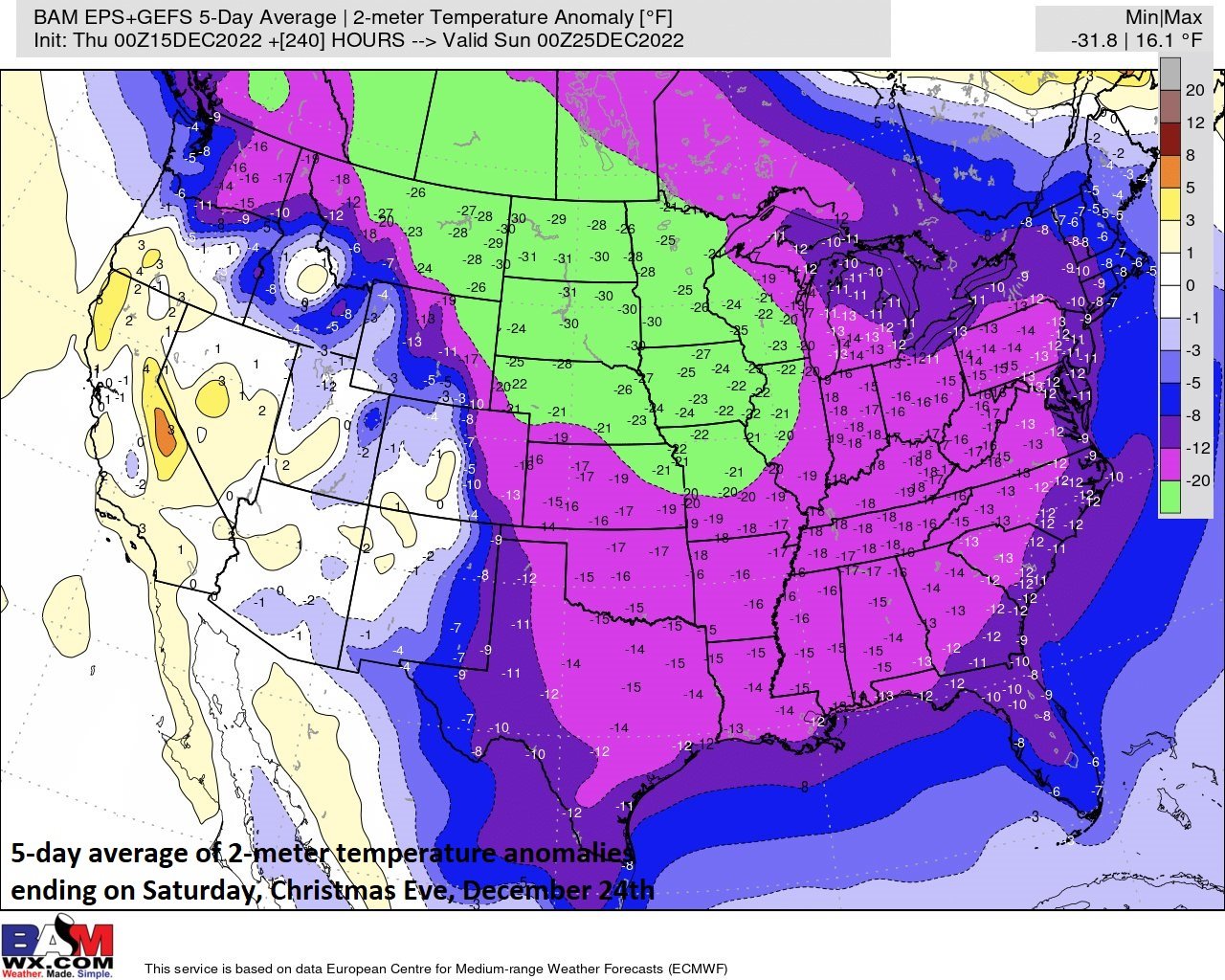
An Arctic outbreak next week will bring temperatures down to well below-normal levels across much of the nation. This forecast map of 2-meter temperature anomalies is from a combination of 00Z ensemble runs of the Euro and GFS. It features some extreme 2-meter temperature anomalies averaged for the 5-day period leading up to Christmas Eve, Saturday, December 24th. Map courtesy ECMWF, NOAA, BAMWX (Twitter)
Record-breaking Arctic blast next week…major storm may precede the Arctic outbreak in the eastern states
A record-breaking Arctic air outbreak is destined to reach the US next week first arriving in the interior northwest and north-central part of the nation and eventually working its way south and east all the way to the Gulf of Mexico and the eastern seaboard. This upcoming cold air outbreak will likely result in numerous broken low temperature records; especially, across the central part of the nation from the Dakotas to Texas. As an example of the severity of this outbreak, temperatures are likely to go well below zero for an extended period of time in the Northern Plains later next week. This kind of intense cold can certainly stress energy grids with demand increasing markedly.
The Arctic air will slide south and east and reach the eastern states by the end of the week. The frigid air mass will stick around right through the subsequent Christmas weekend meaning Christmas Eve and Christmas Day (Saturday, Sunday) may turn out to be the coldest such in many years across much of the eastern half of the nation.

The Arctic air may come in waves during next week and a final push arrives in the eastern states at week’s end. There is a chance that a significant storm develops at the leading edge of this Arctic air outbreak somewhere in the eastern US around next Thursday or Friday. This forecast of 500 mb height anomalies comes from the 12Z GEFS model run and indicates a deep upper-level low will be located in the eastern US. map courtesy NOAA, tropicaltidbits.com
In terms of snow chances, the overall pattern looks to remain quite active and there are signs that a significant storm may form somewhere in the eastern states at the end of next week at the leading edge of the incoming Arctic air mass. This certainly raises hope for a white Christmas in many areas in the Mid-Atlantic and Northeast US, but it is too early to determine the details…stay tuned on that storm possibility and get prepared for an Arctic invasion.
Meteorologist Paul Dorian
Arcfield
arcfieldweather.com
Follow us on Facebook, Twitter, YouTube
Video discussion: