8:15 AM ***Major Arctic outbreak plunges through central US…powerful Arctic front reaches Mid-Atlantic late Friday...damaging winds, quick freeze-up, even a snow squall…very cold Christmas weekend****
Paul Dorian
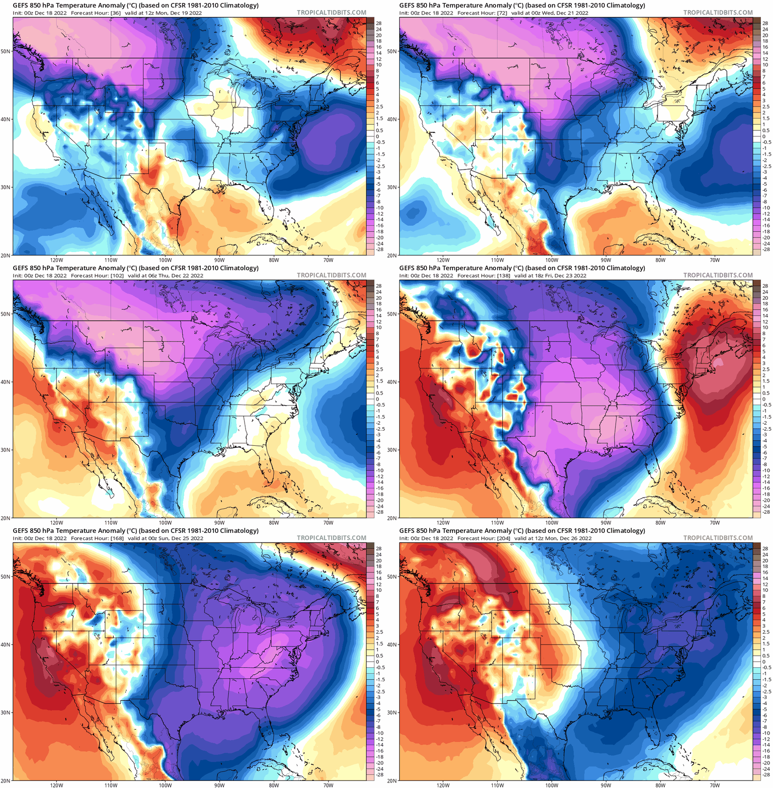
An Arctic outbreak will reach the northwest/north-central states on Monday and this air mass will drop southward to Texas by later in the week. At week’s end, the Arctic air will shift northeastward to the eastern seaboard and the eastern half of the nation will experience a very cold Christmas weekend. 00Z GEFS 850 mb temperature anomaly forecast maps extend in this loop from Monday, December 19th to Monday, December 26th. Maps courtesy NOAA, tropicaltidbits.com
Overview
A major Arctic air outbreak will blast into the US this week. The core of the frigid air will drop southeastward on Monday from western Canada into Montana/North Dakota and then dive southward to Texas by later in the week. Numerous low temperature records are likely to be set in this outbreak all the way from the US/Canada border to the US/Mexico border. The Arctic air mass will then make another move on Friday to the northeast with a powerful surface frontal system at the leading edge of the advancing cold air mass.
The powerful Arctic front will arrive in the Mid-Atlantic’s I-95 corridor likely late Friday and its passage could be quite dramatic. Damaging winds are possible late Friday, temperatures will drop sharply, and there can be a quick freeze-up or “flash-freeze” of any lingering wet spots on roadways. In addition, snow showers or even heavier snow squalls can develop as the Arctic air pours into the region in a still very unstable atmosphere. Christmas Eve (Saturday) and Christmas Day (Sunday) will be very cold throughout the eastern US with some of the coldest weather conditions for these two days in many years.
Major Arctic air outbreak this week
A major Arctic air outbreak will reach the US early this week with the core of the cold first arriving in the interior northwest and north-central part of the nation (Montana/North Dakota). This Arctic air mass will then work its way southward to Texas by later in the week and numerous low-temperature records are likely to be set along the way from the US/Canada border to the US/Mexico border. This frigid air mass had its origins over Siberia on the other side of the North Pole and cross-polar flow aloft has allowed it to be transported from the polar region to western Canada in recent days…next in line is the northern US.
The Arctic front blasts through the Mid-Atlantic I-95 corridor on Friday night and the atmosphere will be quite unstable. As a result, winds can be damaging, temperatures will plunge, and some snow shower or heavier snow squall activity can develop. Map courtesy NOAA, tropicaltidbits.com
Eastern US storm on Thursday; Powerful Arctic frontal passage on Friday night
On Thursday, strong low pressure will form in the eastern US and take an inland track allowing for primarily a rain event in the immediate I-95 corridor region from DC-to-Philly-to-NYC. However, there can be enough cold air in place initially for a brief period of snow and/or ice in some of the northern and western suburbs along the I-95 corridor before stiffening south-to-southeasterly winds pump in much milder air along the eastern seaboard. The rain can get heavy at times from later Thursday into Friday as the low pressure system takes a trek along the spine of the Appalachian Mountains and winds will become very strong. Temperatures can actually surge to well above-normal levels by early Friday along the east coast which at that time, would still be on the front (warm) side of the incoming powerful Arctic frontal system.
The Arctic front likely blasts through the Mid-Atlantic I-95 corridor late Friday and wind gusts can be damaging with a very tight pressure gradient forming between departing strong low pressure to the northeast and incoming strong high pressure to the southwest. The black lines on this 00Z GFS surface forecast map represent lines of equal pressure (isobars) and a very tight pressure gradient is indicated on Friday evening in the Mid-Atlantic/Northeast US. Map courtesy NOAA, tropicaltidbits.com
At the end of the work week, the Arctic air mass will begin to spread to the north and east from the central states towards the Mid-Atlantic region. At the leading edge of this incoming Arctic air mass, there will be a powerful and active surface Arctic frontal system. This front will likely reach the I-95 corridor of the Mid-Atlantic region late Friday and it can be a very dramatic frontal passage. Winds will become very strong with damaging gusts quite likely from late Friday into Saturday (Christmas Eve) – not a good time to be an inflatable Christmas decoration. Temperatures will plunge following the frontal passage and there can be a quick-freeze-up or “flash freeze” of any lingering wet spots on roadways left behind by prior rainfall. In addition, snow showers or even heavier snow squalls may develop late Friday on the back side of the front in a still very unstable atmosphere. If these do snow showers/squalls do materialize, they could put down a quick coating of snow on roadways as temperatures drop sharply.
Christmas Eve (Saturday) and Christmas Day (Sunday) will feature very cold weather conditions in the Mid-Atlantic region and throughout the eastern half of the nation. Indeed, the eastern half of the country will likely experience some of the coldest conditions in many years for Christmas Eve and Christmas Day. Winds will remain quite strong as well for much of the upcoming weekend which could be problematic for the lighting of luminaries in neighborhoods that follow that tradition.
Stay tuned…the late week setup is still a volatile and evolving situation.
Meteorologist Paul Dorian
Arcfield
arcfieldweather.com


