
1:00 PM | ****Major Arctic outbreak reaches northern US…powerful Arctic front reaches I-95 corridor Friday afternoon...damaging winds, "flash-freeze", even a burst of snow…frigid Christmas weekend****
Paul Dorian
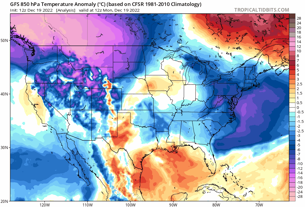
A widespread and intensely cold Arctic air mass has arrived in the northern US and it will dive to Texas by later in the week and then spread eastward into the Mid-Atlantic at week’s end. Numerous low temperature records are likely to be set in coming days; especially, across the central states. Maps courtesy NOAA, tropicaltidbits.com (850 mb temperature anomalies extend from today, Monday, December 19th to next Monday, December 26th)
Overview
A major Arctic air outbreak has reached the interior northwest and north-central states and it will become quite a newsworthy event in coming days. This widespread and intensely cold Arctic air mass will drop southward to Texas by later Thursday and then shift to the east on Friday reaching the eastern seaboard by Friday night. Numerous low temperature records are likely to be set over the next few days; especially, in the central US from the Canadian border to the Mexican border.
At the leading edge of the Arctic air mass will be a powerful surface frontal system that will be very active as it crosses the Great Lakes/Midwest/Ohio Valley from west-to-east. This Arctic front will produce blizzard conditions from the Plains all the way to the Appalachians as it treks west-to-east during the next few days. The powerful Arctic front is likely to arrive in the DC-to-Philly-to-NYC corridor region on Friday afternoon and its passage could be quite dramatic.
Winds will be very strong and potentially damaging for much of the day on Friday in the Mid-Atlantic region both ahead of the Arctic front (S-SE direction) and behind it (W-NW direction)…not a good time for inflatable outdoor decorations. Temperatures will plunge as plunge as much as 25 or 30 degrees behind the front in just a couple of hours from the mild 50’s in the morning to the 20’s by day’s end. This sharp drop in temperatures can result in a “flash freeze” of any lingering wet spots on roadways from prior rainfall.
In addition, a burst of snow is possible immediately following the frontal passage which can even put down small accumulations in some spots as the Arctic air pours into the region in a still very unstable atmosphere. Christmas Eve (Saturday) and Christmas Day (Sunday) will be very cold throughout the eastern US with some of the coldest weather conditions for these two days in many years. Single digits are on the table in suburbs along the I-95 corridor both on Saturday and Sunday (Christmas) mornings.
Major and widespread Arctic air outbreak in the central US
A major and widespread Arctic air outbreak has reached Montana and North Dakota today and the core of this cold air mass will drop southward to Texas by later in the week. This intensely cold outbreak will very likely result in numerous low temperature records over the next few days; especially, in the central US all the way from the Canadian border to the Mexican border. This frigid cold air mass had its origins on the other side of the North Pole over Siberia and cross-polar flow that developed aloft in recent days has allowed it to be transported into western Canada and now into the northern US.
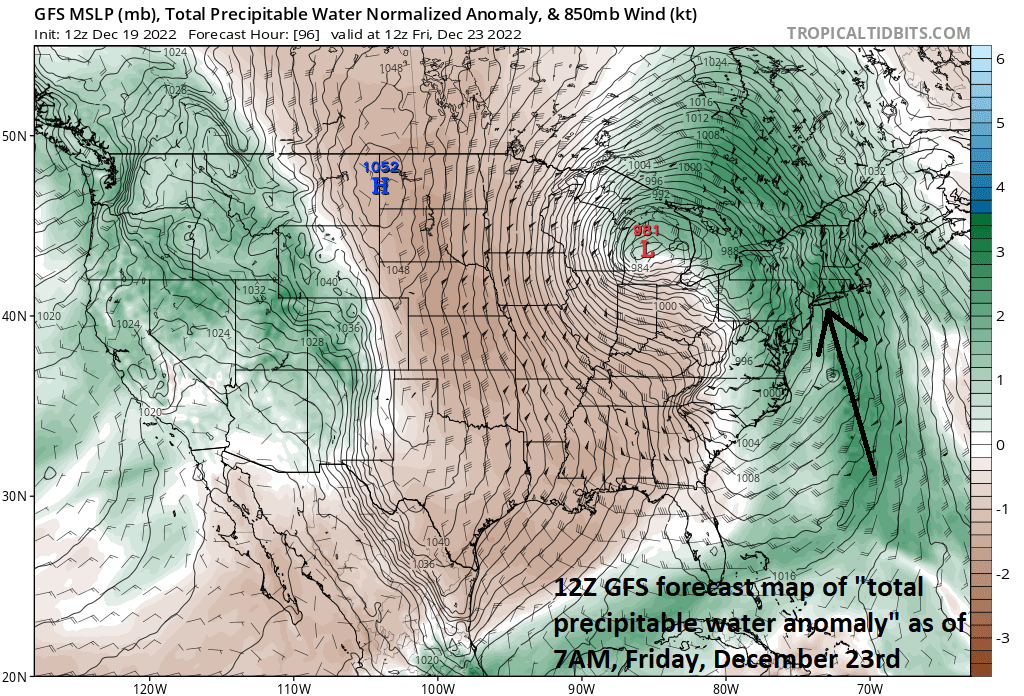
A storm will result in a soaking rainfall in the Mid-Atlantic region from early Thursday into Friday morning and a thunderstorm cannot be ruled out during this event. An inland track of low pressure on Thursday will generate a surge of mild and moist air up along the eastern seaboard resulting in plain rain; however, there can be a brief period of snow and/or ice at the onset in some of the far northern and western suburbs along the I-95 corridor. Map courtesy NOAA, tropicaltidbits.com
Mid-Atlantic rainstorm from early Thursday into early Friday
On Thursday, strong low pressure in the eastern US and it will push northward taking an inland track over the Appalachian Mountains. As such, it will pull much milder air from the southeastern states and western Atlantic Ocean northward up along the eastern seaboard assuring primarily a rain event for the Mid-Atlantic region. There is a slight chance that enough cold air will be lingering around early on Thursday to result in a brief period of snow and/or ice in some of the far northern and western suburbs; however, increasingly strong S-SE winds will enable temperatures to climb to well above freezing levels by later in the day. The rain can indeed fall heavily at times from later Thursday into Friday morning and a thunderstorm or two cannot be ruled out. This surge of mild air will likely peak on Friday morning with the 50’s possible in the immediate I-95 corridor, but that warmth will disappear abruptly later in the day on Friday.

A powerful Arctic front will likely arrive in the DC-to-Philly-to-NYC corridor on Friday afternoon and its passage will be quite dramatic. Winds will be quite strong on Friday, temperatures will plunge in the immediate aftermath of the frontal passage, a ‘flash-freeze” is possible and there can be a burst of snow. Maps courtesy NOAA, tropicaltidbits.com (1PM Friday, left; 7PM Friday, right)
Powerful Arctic frontal passage on Friday afternoon
On Friday afternoon, the leading edge of this record-breaking Arctic air mass will reach the Mid-Atlantic’s I-95 corridor. The powerful Arctic surface front will likely have quite a dramatic passage on Friday afternoon in this region with strong and potentially damaging winds shifting to a W-NW direction, plunging temperatures as much as 25 or 30 degrees in just a couple of hours and this can cause a quick freeze-up or “flash freeze” of any lingering wet spots on roadways from the prior rainfall. In addition, there can be a burst of snow in the immediate aftermath of the frontal passage even producing small accumulations in some spots.

Single digits temperatures are on the table in the DC-to-Philly-to-NYC corridor both on Saturday morning (Christmas Eve) and Sunday morning (Christmas Day). This forecast map of 2-meter temperatures for early Sunday comes from the 12Z GFS (courtesy NOAA, tropicaltidbits.com)
Temperatures will continue to drop sharply on Friday night and the weekend promises to be frigid not only in the Mid-Atlantic region, but throughout the eastern half of the nation. In fact, this will likely turn out to be the coldest Christmas Eve (Saturday) and Christmas Day (Sunday) in many years in the eastern half of the country. Single digit temperatures are on the table in the DC-to-Philly-to-NYC corridor both on Saturday morning and Sunday (Christmas) morning. Winds will remain quite strong all weekend long making it quite difficult for the lighting of luminaries in those neighborhoods that follow that tradition. In terms of a follow-up thaw in the eastern US, it is pretty much inevitable that temperatures will become noticeably milder next week as this incoming Arctic air mass in the central and eastern US will actually be the coldest air in all of North America.
Stay tuned as we’ll continue to monitor the late week setup which is still a volatile and evolving situation. For example, the timing of the Arctic front will be quite important and the current expectation of early-to-mid Friday afternoon in the DC-to-Philly-to-NYC corridor is not yet set in stone.
Meteorologist Paul Dorian
Arcfield
arcfieldweather.com
Follow us on Facebook, Twitter, YouTube
Video discussion: