10:00 AM | ****Buckle up…wild and crazy weather next 36 hours in the Mid-Atlantic/Northeast US****
Paul Dorian

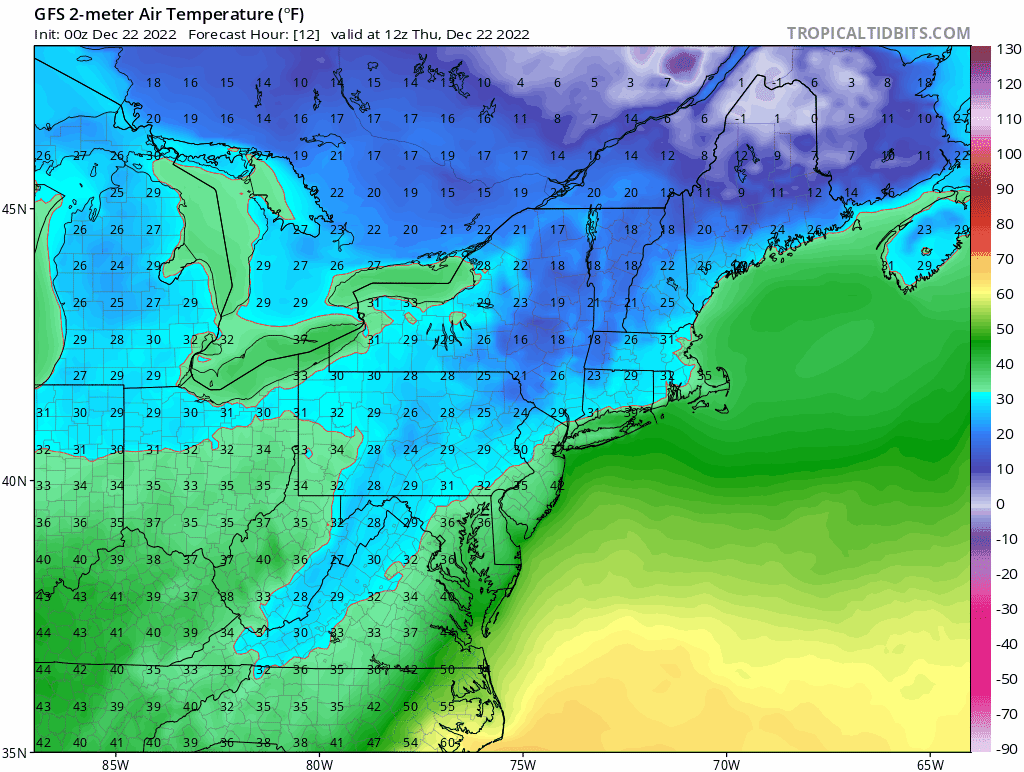
Temperatures will plunge in the aftermath of the Arctic frontal passage on Friday morning in the Mid-Atlantic’s I-95 corridor likely bottoming out in single digits by later tomorrow night. In addition to the bitter cold air temperatures, winds will be very strong producing dangerously low wind chill levels of well below zero on Friday night and Saturday. Maps courtesy NOAA, tropicaltidbits.com (loop extends from Thursday morning to Sunday morning)
Overview
Buckle up…the next 36 hours or so in the Mid-Atlantic/Northeast US will feature some wild and crazy weather to include the following:
-heavy rain including thunderstorms
-localized flash flooding and tidal flooding at the coast
-a surge in temperatures to the 50’s
-extreme plunge in temperatures to the single digits in I-95 corridor, below zero interior
-flash-freeze
-a burst of snow with small accumulations
-powerful and potentially damaging wind gusts
All of this weather can take place between about noon today and midnight tomorrow night headlined by a soaking rain event into early Friday and then the arrival of an intensely cold Arctic air mass later Friday morning.
An intensely cold Arctic air mass will plunge deep into Texas today and spread east reaching the eastern states on Friday morning. Temperatures will likely bottom out in single digits by later tomorrow night in much of the Mid-Atlantic’s I-95 corridor and below zero in much of the interior sections of the northeastern states. Maps courtesy NOAA, tropicaltidbits.com (loop extends from Thursday morning to Sunday morning)
Details
An intensely cold Arctic air mass is now plunging south into Texas and spreading east into the Upper Midwest where blizzard conditions are developing. This frigid cold air mass had its origins on the other side of the North Pole over Siberia and “cross-polar” flow has allowed it to be transported from there to northwestern Canada and now into the heartland of our nation. Numerous low temperature records have been set already with this invading air mass - including the all-time record low of -42 degrees in Casper, Wyoming (previous record in 1990) - and more records will no doubt be broken in coming days.
Meanwhile, in the eastern US, low pressure is intensifying, and it will push rain and milder air into the Mid-Atlantic and Northeast US as it takes an inland track. In some of the northern and western suburbs along the I-95 corridor, the rain has begun as a wintry mix; however, this mixing should be brief as temperatures are to climb to well above freezing levels by later in the day. The rain can indeed fall heavily at times from later today into early Friday morning and a thunderstorm or two cannot be ruled out in this soaking rain event….watch out for localized flash flooding. This surge of milder air will likely peak by late tonight/early Friday morning with temperatures at or above 50 degrees in some spots, but that warmth will disappear abruptly later in the morning on Friday.

All kinds of weather warnings displayed on this map for the US ranging from blizzard warnings (orange, Upper Midwest) to flash flood watches (green, Mid-Atlantic/NE US).
The leading edge of an intensely cold Arctic air mass will reach the Mid-Atlantic’s I-95 corridor on Friday morning. The powerful Arctic surface front will have quite a dramatic passage with strong and potentially damaging winds shifting to a W-NW direction, plunging temperatures as much as 30+ degrees in a short period of time and this can cause a quick freeze-up or “flash freeze” of any lingering wet spots on roadways from the prior rainfall. In addition, there can be a burst of snow in the immediate aftermath of the frontal passage potentially producing a quick accumulation of a coating to an inch or two adding to the potential difficult travel conditions.

A tremendous pressure gradient will form between very strong high pressure over the Northern Rocky Mountain states and intensifying low pressure over the Great Lakes contributing to wind gusts of 50-70 mph in a widespread part of the country. Map courtesy NOAA, tropicaltidbits.com
Temperatures will continue to drop sharply on Friday night and the weekend promises to be frigid not only in the Mid-Atlantic region, but throughout the eastern half of the nation. In fact, this will likely turn out to be the coldest Christmas Eve (Saturday) and Christmas Day (Sunday) in many years in the eastern half of the country. Single digit temperatures are likely all along the I-95 corridor both on Saturday morning and again on Sunday (Christmas) morning and many spots in the interior of the northeastern part of the nation will drop to below zero. Winds will remain quite strong all weekend long making for dangerous wind chills of well below zero. In terms of a follow-up thaw in the eastern US, it is pretty much inevitable that temperatures will become noticeably milder relative-to-normal later next week as this incoming Arctic air mass in the central and eastern US will actually be some of the coldest air in all of North America. The thaw later next week can continue into the first week of January while the atmosphere across the north land begins to “re-load” with the formation of new cold air masses.
Notes on the upcoming cold weekend in Philly… The last time the high on Christmas Day itself stayed below 30 in Philly - a certainty this year - was back in 2000 when the high was only 27. The last time both Christmas Eve and Christmas Day stayed below 30 in Philly - a certainty this year - was back in 1989 when the high on Christmas Eve was 21 and the high on Christmas Day was 28. So this year’s Christmas weekend has the potential to be the coldest in over 30 years (source Philly NWS).
Meteorologist Paul Dorian
Arcfield
arcfieldweather.com
Follow us on Facebook, Twitter, YouTube
Video discussion: