
2:00 PM (Fri.) | ****Rain/snow in Mid-Atl. on Sunday…mid-week Northern Plains blizzard, MS/TN Valley severe weather threat...wintry mix possible in Mid-Atl. Thurs/Fri...…cross-polar flow****
Paul Dorian
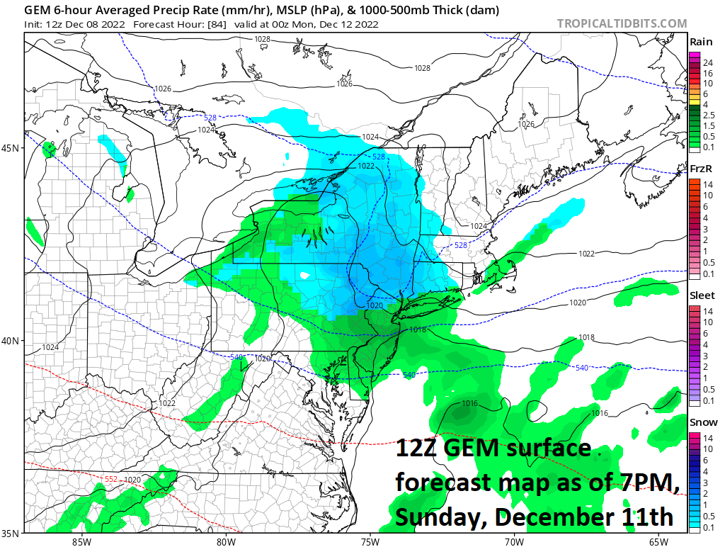
Low pressure will intensify off the Mid-Atlantic coastline late Sunday and enough cold air will be around for some snow in parts of the Mid-Atlantic region. Map courtesy NOAA, tropicaltidbits.com
Overview
The overall weather pattern across the nation will be quite active from later this weekend through next week with multiple storm threats. One low pressure system will form over the Midwest on Saturday and then its precipitation shield will push into the Mid-Atlantic region on Sunday. Enough cold air will be around for snow on Sunday in much of the northern Mid-Atlantic with accumulations of up to a few inches likely in some interior and higher elevation locations. Another storm system will wreak havoc across much of the nation next week with a possible severe weather outbreak late Tuesday/Tuesday night in the Lower Mississippi and Tennessee Valleys and blizzard conditions across the Northern Plains. This system and its precipitation field likely reaches the eastern states later next week and frozen precipitation will likely be in the mix: especially, if re-development of a surface low takes place near the east coast which could make for a more serious winter storm threat in the Mid-Atlantic. The evolving pattern should feature more sustained cold air in the eastern states following that mid-to-late week storm system and “cross-polar flow” later this month will assure some very cold air masses reaching into North America.

Low pressure will intensify late Sunday near the Mid-Atlantic coastline and enough cold air may be drawn into the system from northwest-to-southeast to result in some accumulating snow for interior and higher elevation locations. The upper-level vorticity field will be crucial in the final determination of the where the best chance for accumulating snow will set up and it is currently being handled somewhat differently for Sunday evening by computer forecast models such as the Canadian (left), GFS (middle) and NAM (right). Maps courtesy NOAA, Canadian Met Centre, tropicaltidbits.com
Details
It is rather tranquil across the nation today, but there will be multiple storm systems to deal from later this weekend through next week. On Saturday morning, low pressure will develop across the central part of the nation with somewhat limited cold air to work with and it will slide eastward into the Ohio Valley by early Sunday. This system will then begin to strengthen and drop to the south and east from the Great Lakes to the Mid-Atlantic coastline as it encounters a strong blocking pattern in the atmosphere over Canada. As a result, colder air will tend to drop to the south and east on Sunday and snow will fall across much of the northern Mid-Atlantic region with accumulations likely in many interior and higher elevation locations. For example, up to 3 or 4 inches can fall on Sunday and Sunday night in the region from the Poconos of northeastern PA to NW New Jersey to the Lower Hudson Valley region of southeastern New York. There can even be a trace to an inch or so of snow down to Philly and its surrounding suburbs across southeastern PA.

A strong storm could cause severe weather to break out late Tuesday/Tuesday night of next week across the Lower Mississippi and Tennessee Valleys, a blizzard across the Northern Plains, and then its precipitation shield will push to the eastern states later next week. There may be enough cold air in the Mid-Atlantic region later next week for frozen precipitation to be in the mix; especially, if the storm re-develops near the east coast which could make a more serious winter storm threat. Map courtesy NOAA, tropicaltidbits.com
By Tuesday of next week, another storm system will intensify over the central Plains. This system will have all the ingredients to raise the threat of severe weather in its warm sector in places like the Lower Mississippi and Tennessee Valleys – perhaps even to include the threat of tornadoes. In the cold sector, a blizzard is likely to develop with significant accumulating snow and powerful winds by later Tuesday/Tuesday night across the Northern Plains (Dakotas) and Upper Midwest (Minnesota/Upper Wisconsin).
The primary surface low pressure will head northeast towards the Great Lakes and with very strong blocking in the atmosphere over Canada, it my grind to a halt there and re-development of surface low pressure could take place near the eastern seaboard later next week. Enough cold air will be around for the possibility of frozen precipitation in the Mid-Atlantic region during this event and we’ll have to monitor closely the chance for formation of a new low pressure system near the east coast. If this were indeed to take place, the Mid-Atlantic region could face a significant winter storm threat later in the Thursday/Thursday night time frame…stay tuned.

Following the passage of the strong storm system later next week and its associated cold front, colder air will push into the eastern US and this influx of cold air could be the beginning of a more sustained colder-than-normal weather pattern for the central and eastern states. In fact, there are signs that later this month, “cross-polar” flow will develop and this would assure the movement of some very cold air from the polar region into northern Canada - and perhaps ultimately into the northern US and just in time for Christmas.
Meteorologist Paul Dorian
Arcfield
arcfieldweather.com
Follow us on Facebook, Twitter, YouTube
Video discussion: