
1:00 PM | ****Ice threat continues for later Thursday/Thursday night in much of the Mid-Atlantic region****
Paul Dorian

The biggest concern with the late week wintry event is a buildup of ice as depicted here by the 12Z GFS computer forecast model. Map courtesy NOAA, Pivotal Weather
Overview
Today will be another mild day in the Mid-Atlantic region with periods of rain as low pressure pushes from the Upper Midwest towards the southeastern part of Canada. The current mild stretch will peak on Wednesday afternoon with the breakout of sunshine after a cloudy start and temperatures are quite likely going to reach 65-70 degrees in the DC-to-Philly-to-NYC corridor. The passage of a cold front later tomorrow will then bring about big changes in the temperature department in the overnight hours setting the stage for a winter weather event from later Thursday into early Friday. The winter weather event could include some snow accumulations; primarily, across the northern Mid-Atlantic and a potential significant buildup of ice in places like southern and central Pennsylvania.
Current mild stretch peaks on Wednesday afternoon in the Mid-Atlantic and then the ice/snow threat
The mild conditions of today and tonight will be accompanied by some rainfall for us as low pressure pushes from the Upper Midwest to the southeastern part of Canada. On Wednesday, temperatures could easily soar to 65-70 degrees in DC, Philly and NYC with the breakout of some sunshine, but a cold front will drop through the region later in the day. Temperatures will tumble in the overnight hours following the passage of the cold front setting the stage for a wintry mess from later Thursday into early Friday.

After a very mild Wednesday, the passage of a cold front will set temperatures tumbling in the overnight hours leading to a wintry mess on Thursday and Thursday night. Map courtesy NOAA, tropicaltidbits.com
It is on Thursday when the overall weather pattern will get more active in the Mid-Atlantic region and also quite difficult in terms of pinpointing precipitation types in given spots that will range from snow-to-sleet-to-freezing rain-to-plain rain. Strong high pressure will build across the Great Lakes from Wednesday night into Thursday and it’ll have an extension into the southeastern part of Canada. From this position, low-level cold, dense air will be able to make its way down the spine of the Appalachian Mountains in an atmospheric set-up known as “cold air damming”. At the same time, the influx of the cold air in the upper part of the atmosphere will have some trouble advancing to the south as the west-to-east upper-air wind flow will tend to inhibit its advance in that direction. “Cold air damming” can result in some serious icing issues if indeed there is the combination of low-level cold, dense air and slightly warmer (i.e., slightly above freezing) layers in the upper part of the atmosphere. Another feature of “cold air damming” is the formation of low pressure off the Mid-Atlantic coastline and this is a possibility later Thursday into Thursday night which would help to maintain the low-level cold air in place on the east side of the Appalachians.
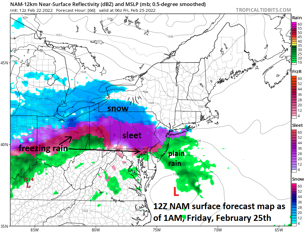
Lots of colors on this forecast map for late Thursday night/early Friday and that is never a good thing this time of year as it depicts a range of precipitation types from plain rain-to-freezing rain-to-sleet-to-snow. Map courtesy NOAA, tropicaltidbits.com
The best chance for sleet and/or freezing rain during the day on Thursday may be in areas to the south of the PA/MD border and it is likely to be on the light side. Then the precipitation shield will expand and intensify across southern and central Pennsylvania late in the day or early Thursday night. There can be snow at the onset in southeastern and east-central Pennsylvania and even some accumulations are on the table. However, a transition from snow to sleet to freezing rain is quite likely later in the evening on Thursday and there can be a significant ice buildup; especially, across southern and central PA . In fact, the concern for a buildup of ice could end up extending as far south as the northern suburbs of Washington, D.C. If the period of snow in southeastern and east-central PA ends up lasting for a longer period of time - a scenario that is on the table - then the ice buildup would perhaps become a bit less of a threat and there would be more in the way of snow accumulations…pick your poison.

The latest Euro model forecast map for early Friday afternoon depicts a large area of freezing rain (pink) across much of Pennsylvania, northern NJ and southeastern NY. Map courtesy ECMWF, Weather Bell Analytics
Farther to the north, in places like northern Pennsylvania and interior southeastern New York, it may be cold enough at all levels of the atmosphere for significant accumulating snow to fall – at least at the onset of this late week storm system. There is still a couple of days to go and fine-tuning of the details is always necessary when dealing with a wide variety of conditions over a small area ranging plain rain-to-freezing rain-to-sleet-to-snow…stay tuned.
Meteorologist Paul Dorian
Arcfield
arcfieldweather.com
Follow us on Facebook, Twitter, YouTube
Video discussion: