
11:45 AM | ***A late weekend snow threat to monitor for the Mid-Atlantic region***
Paul Dorian

12Z GFS forecast map of 500 mb vorticity field as of 7AM, Sunday with two notable disturbances (circled). If the northern and southern stream waves “phase together” in a quick enough fashion, low pressure just off the east coast could enhance snowfall amounts in the Mid-Atlantic region. Map courtesy NOAA, tropicaltidbits.com
Overview
The next few days will be relatively quiet in the Mid-Atlantic region and somewhat milder than recent days. There will be a couple of weak frontal systems to deal with during the next couple of nights, but, in general, high pressure will be the main player as we head into the weekend. It is at this time, the overall pattern becomes much more active. After a mild beginning to the weekend, an Arctic cold front will head into the eastern states from northwest-to-southeast and it will tend to slow down upon its arrival. Snow could actually break out along the slowing-down frontal boundary zone in the Mid-Atlantic region as we head into the second half of the weekend and low pressure will try to intensify off the east coast. A situation that needs to be closely monitored in coming days.
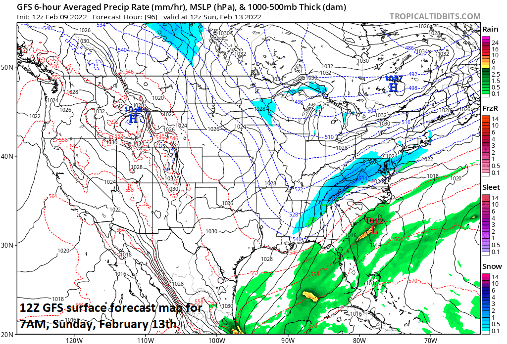
12Z GFS surface forecast map for 7AM, Sunday with snow (in blue) depicted in portions of the Mid-Atlantic region. Map courtesy NOAA, tropicaltidbits.com
Details
Each of the next few days will feature some sunshine in the DC-to-Philly-to-NYC corridor and temperatures will be milder than recent days. There can be a rain or snow shower tonight with a weak cold frontal passage and another weak cold front will pass through tomorrow night, but neither one of these will have a big impact on overall temperatures.

While it is too early to determine potential late weekend snowfall amounts in the Mid-Atlantic region, it is quite certain that an Arctic blast will arrive for the Sunday/Monday/Tuesday time period. Map courtesy NOAA/WPC, tropicaltidbits.com
By early Saturday, another cold front will arrive in the eastern states and this one will be much stronger and will have an Arctic air mass behind it supported by strong high pressure to our north and northwest. As the Arctic cold front pushes into the eastern states, its southwest-to-northeast orientation will become aligned with the overall upper-air wind flow and the result will be a slowing-down frontal system. Multiple upper-air disturbances in the northern and southern branches of the jet stream will then attempt to “phase together” by later in the weekend and low pressure will begin to organize off the Southeast US coastline.
Snow could actually break out along the I-95 corridor by early Sunday morning in the vicinity of the slowly-moving Arctic cold frontal system at the same time low pressure begins to strengthen off the coast. If the phasing takes place in a quick enough fashion, the developing low can enhance snowfall in the I-95 corridor on Sunday…still a little too early to determine those prospects. While it is too early to pinpoint the prospects for accumulating snow, it is quite certain that it will turn much colder for the Sunday/Monday/Tuesday time period as compared with the milder conditions of the late week and early part of the weekend…stay tuned on this unfolding scenario.
Meteorologist Paul Dorian
Arcfield
arcfieldweather.com
Follow us on Facebook, Twitter, YouTube
Video discussion: