1:00 PM | *Severe weather threats continue…”sub-tropical” system to back towards east coast next week as strong ridging aloft forms over SE Canada*
Paul Dorian
An anomalously strong high pressure ridge will set up in the upper part of the atmosphere over southeastern Canada by the early and middle parts of next week. This system will help to steer stalled-out low pressure from the western Atlantic back towards the US east coast later next week. Map courtesy NOAA, tropicaltidbits.com
Overview
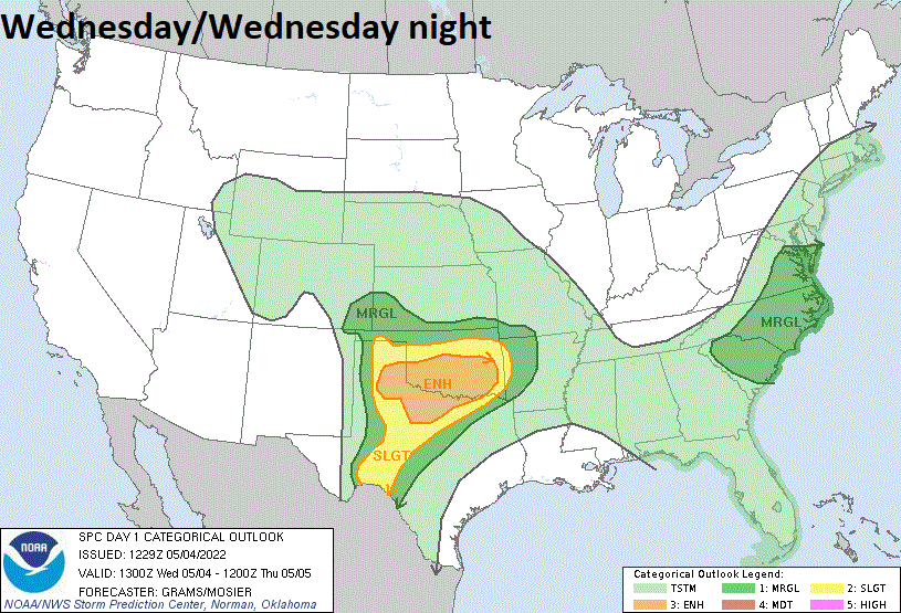
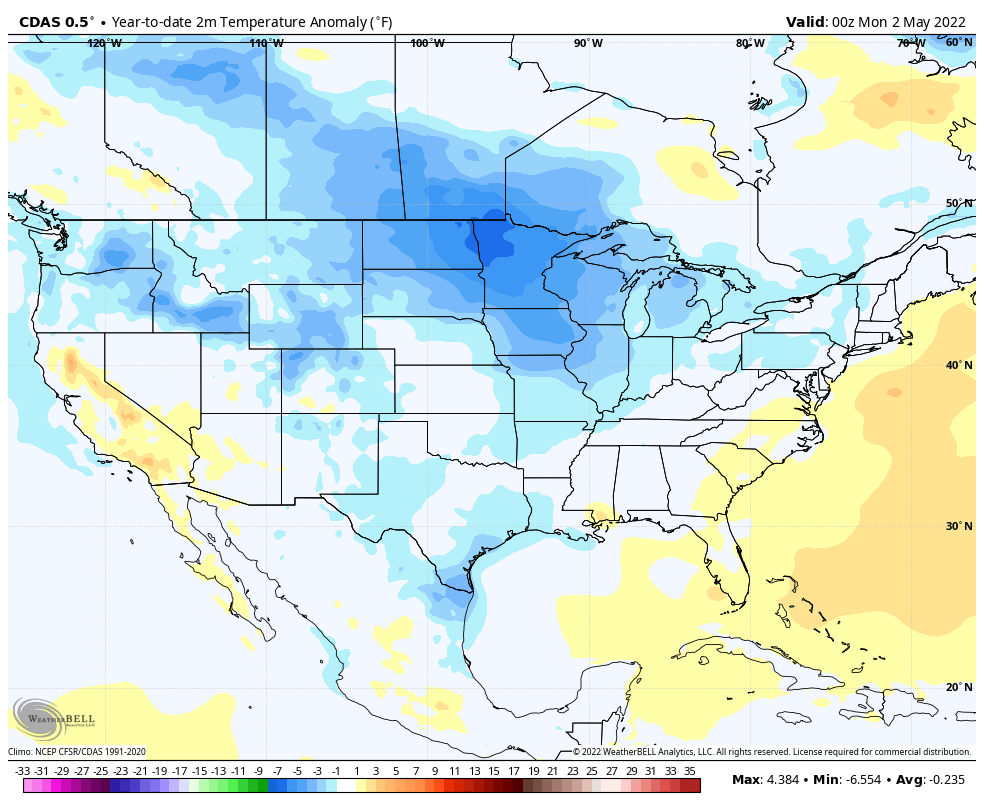
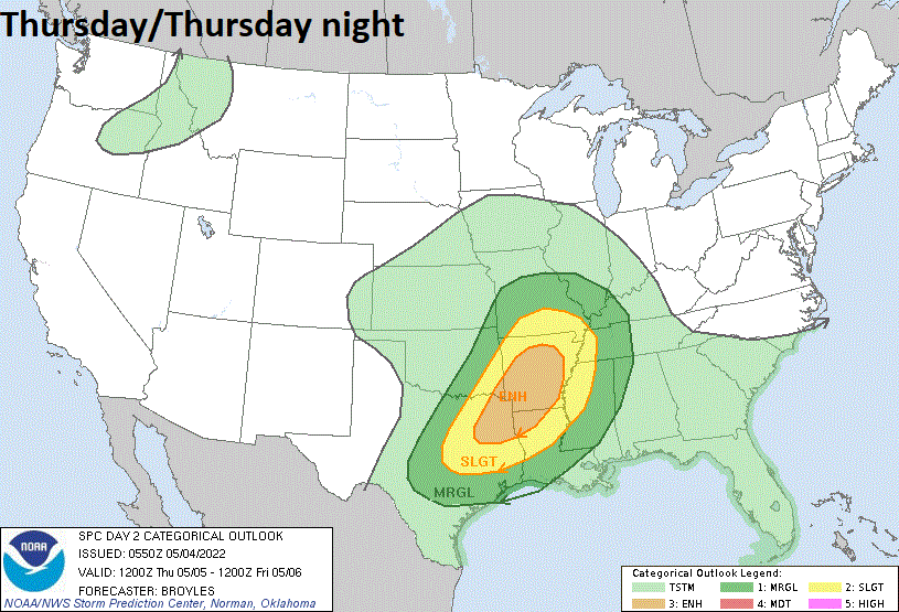
An active weather pattern continues across the nation and the overall situation in the upper part of the atmosphere will take on a different twist later this weekend and next week. One of the reasons this pattern has been so active has been an on-going onslaught of colder-than-normal air masses from Canada into the US which adds to the possibility of severe weather outbreaks. One area of concern later today and tonight for the possibility of severe weather is the southern Plains with a focus of attention on Oklahoma and northern Texas. This “enhanced” severe weather threat will shift slightly to the east on Thursday. Looking ahead, very strong high pressure ridging will develop over southeastern Canada later this weekend and into next week and this setup could actually help to push an offshore stalled-out low pressure system back towards the west and to the east coast sometime later next week.
An “enhanced” risk of severe weather develops later today and tonight across much of northern Texas and Oklahoma as an active weather pattern continues across the nation. Map courtesy NOAA/SPC
Details
As long as colder-than-normal air masses continue to drop into the US from Canada an active weather pattern will continue for much of the nation with the possibility of severe weather outbreaks. Indeed, the chance of severe weather will increase later today and tonight across the southern Plains with a focus of attention on northern Texas and Oklahoma where numerous severe thunderstorms are likely to form.
The “year-to-date” 2-meter temperature anomalies across the nation reveal much of the US with colder-than-normal conditions from January 1st through the month of April. In recent weeks, colder-than-normal air masses have frequently visited the US from Canada and this has led to a very active (and still on-going) weather pattern. Map courtesy Weather Bell Analytics (Joe Bastardi/Twitter), NOAA..
Colder air is pushing eastward from the Rockies where some snow can actually fall in the highest elevations and at the same time, warmer and more humid air with dew points in the 60’s is pushing northward out of the Gulf of Mexico and into the southern Plains. The severe weather threat in Texas and Oklahoma for later today and tonight will include the possibility of large hail and strong tornadoes with the likely development of supercell thunderstorms. This area of concern will shift slightly to the east on Thursday with the highest probability for severe weather tomorrow/tomorrow night centered over Arkansas, northeastern Texas and northwestern Louisiana.
Severe weather threat zone shifts slightly to the east on Thursday with an “enhanced” risk over NE TX, NW LA, and much of the state of Arkansas. Map courtesy NOAA/SPC
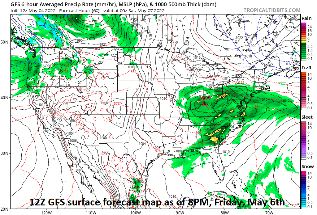
An area of low pressure will then push eastward on Friday across the Ohio Valley and bring a soaking rain event to much of the Mid-Atlantic region at the end of the work week and into the first half of the upcoming weekend. It’ll turn noticeably cooler as well in the Mid-Atlantic region during this rain event. This low pressure system will then push off the east coast later in the weekend and grind to a halt out over the western Atlantic.
A soaking rain event is coming to the Ohio Valley and Mid-Atlantic region from later Thursday into Saturday. This low pressure system will then stall-out over the western Atlantic this weekend and likely push west towards the US east coast later next week as a “sub-tropical” low. Map courtesy NOAA, tropicaltidbits.com
Meanwhile, a very strong high pressure ridge will develop in the upper part of the atmosphere centered over the southeastern part of Canada. This anomalously strong ridge of high pressure will help to steer the stalled-out low pressure system back towards the east coast later next week. This system can be considered to be “sub-tropical” in nature, but whether NOAA’s hurricane center names it as a “tropical” system is anyone’s guess. Whatever it is called, it’s retrogression back to the west as a result of the strong ridging aloft over southeastern Canada can result in an impact later next week somewhere along the US east coast.
Meteorologist Paul Dorian
Arcfield
arcfieldweather.com
Follow us on Facebook, Twitter, YouTube
Video discussion:


