
10:00 AM | *Below-normal tropical activity so far this season in the Atlantic Basin (and across the northern hemisphere)…a ramp up in action is quite likely during the next several weeks*
Paul Dorian

Tropical activity is not expected in the near-term across the Atlantic Basin and the season has been quieter-than-normal so far; however, some signs point to an increase in action in coming weeks. Map courtesy NOAA/NHC
Overview
We have now reached the mid-point of the month of July and, so far, tropical activity has been below-normal in the Atlantic Basin. In fact, activity across the northern hemisphere as a whole has been below-normal as measured by a metric known as the “accumulated cyclone energy” or ACE. There are signs, however, that at least the Atlantic Basin will see a ramp up in action during the next several weeks.
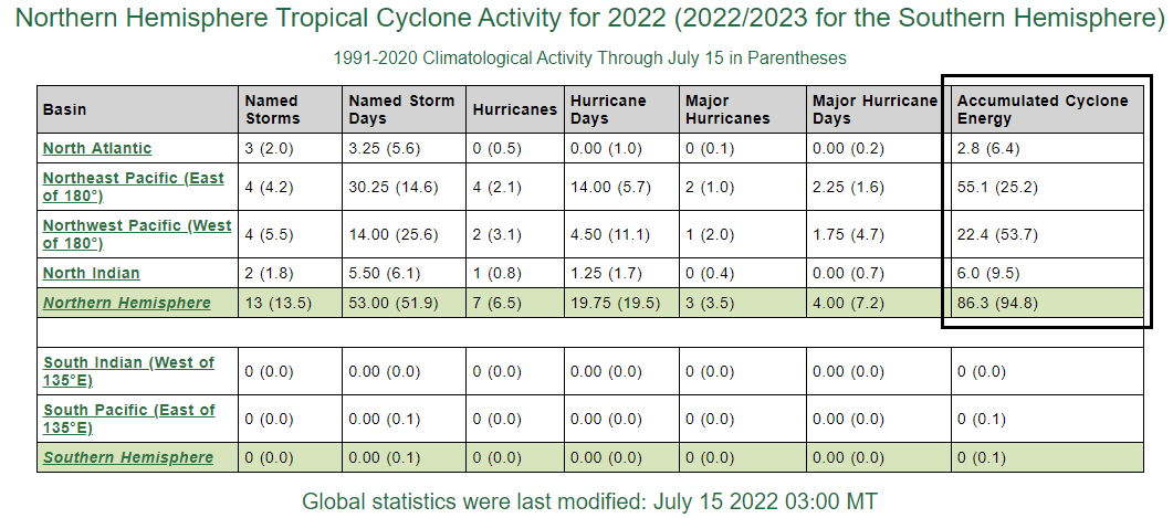
One of the best measurements of tropical activity is known as the “accumulated cyclone energy” or ACE and it is currently at below-normal levels in the Atlantic Basin and the northern hemisphere as a whole (right column). Data courtesy Colorado Sate University
Accumulated Cyclone Energy
One of the most accurate ways to monitor overall tropical activity is through the usage of a metric known as the accumulated cyclone energy or “ACE”. The ACE metric - which was originally created by Dr. William Gray and associates at Colorado State University and later tweaked by NOAA - not only factors in the intensity of a tropical cyclone, it also takes into account its longevity. A “major” hurricane, for example, that lasts for a long time will have a much bigger impact on the accumulated cyclone energy than a short-lived and weaker tropical system.
So far this tropical season – and there is a long way to go - activity has been below-normal in the Atlantic Basin, western Pacific and Indian Oceans with only the eastern Pacific experiencing more “accumulated cyclone energy (ACE)” than normal. In fact, the Atlantic Basin has accumulated less than half the normal cyclone energy as we have reached the mid-point of July, but that may begin to change pretty soon.
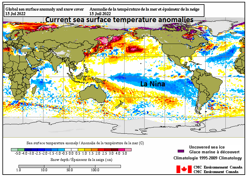
One big factor in this year’s tropical season is another “La Nina” event in which colder-than-normal temperatures (shown in blue) dominate the scene across the equatorial Pacific Ocean. In fact, “La Nina” conditions have dominated the scene in this part of the world for three consecutive tropical seasons. Map courtesy Canadian Met Centre
Sea surface temperatures
Sea surface temperatures have a big impact on tropical activity around the world and the equatorial part of the Pacific Ocean is experiencing another “La Nina” episode with colder-than-normal water temperatures. In fact, this is the third straight season with La Nina conditions in the tropical Pacific Ocean and such “back-to-back-to-back” events are certainly rather uncommon. Typically, colder-than-normal sea surface temperatures in the tropical Pacific Ocean lead to reduced overall wind shear in the tropical Atlantic Ocean and this, in turn, is a favorable factor for the formation and intensification of tropical cyclones in the Atlantic Basin. So far, that observation has not exactly held true to form; however, the season is still rather young and water temperatures have not yet reached their peak which is one of the reasons the tropical season tends to peak as late as mid-September. In addition to the expected general uptick in sea surface temperatures which is favorable for increased tropical activity, an index known as the “Madden-Julian Oscillation” or MJO is indicating conditions may become more favorable in coming weeks.
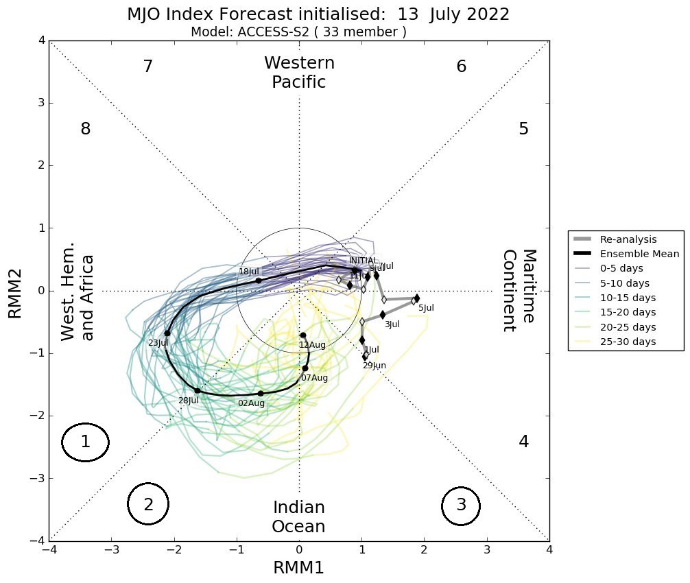
The Madden-Julian Oscillation (MJO) is expected to swing into “phases” 1, 2 and 3 in coming weeks and this is typically suggestive of a more favorable pattern for tropical activity in the Atlantic Basin. Plot courtesy Meteorologist Joe Bastardi, Twitter
Madden-Julian Oscillation (MJO)
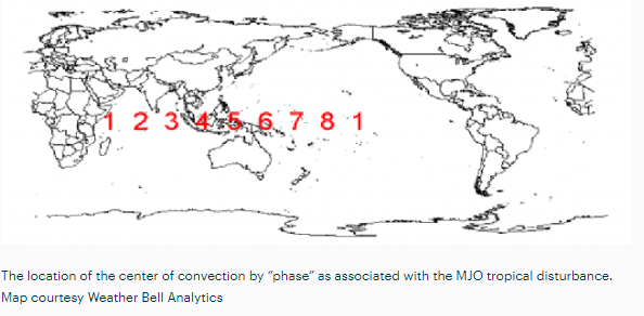
The MJO can be characterized as an eastward moving “wave” or “pulse” of clouds and enhanced tropical rainfall near the equator that typically recurs every 30-to-60 days. The anomalous rainfall is often first evident over the Indian Ocean, and remains apparent as it propagates eastward over the very warm waters of the western and central tropical Pacific. Over the cooler ocean waters of the eastern Pacific, the pattern of tropical rainfall generally becomes nondescript, but often reappears over the tropical Atlantic and Africa. One method meteorologists use to monitor the MJO is in an 8-phase diagram in which each phase generally coincides with locations along the equator around the globe. In addition to being informative about the location of the MJO, these phase diagrams provide some information to meteorologist as to the strength of the tropical disturbance as it traverses the tropics. Specifically, when the MJO index is within the center circle of the forecast plots, it is considered to be weak and when it is outside, it is stronger and usually moves in a counter-clockwise direction.
The different phases of the MJO correlate well with different temperature and precipitation patterns around the world depending on the given time of year. The current forecast by several computer forecast models, indicate that the MJO will swing into phases 1, 2 and 3 as we progress through the rest of July and into the month of August. Past observations show that these particular phases of the MJO during this time of year are quite supportive of increased tropical activity in the Atlantic Basin.
Bottom line, while the tropical season has been quieter-than-normal so far in the Atlantic Basin, there is plenty of time to go and signs point to a change as we head through the second half of the month and into August.
Meteorologist Paul Dorian
Arcfield
arcfieldweather.com
Follow us on Facebook, Twitter, YouTube
Video discussion: