10:00 AM | **First extended heat wave of the summer in the Mid-Atlantic region lasts through Sunday…a run to 100 degrees on the table in some spots this weekend**
Paul Dorian
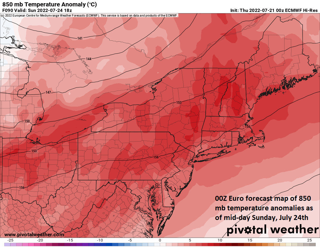
The current heat wave in the Mid-Atlantic region will continue through the upcoming weekend and the peak could come on Sunday afternoon with a run to 100 degrees in some spots. This forecast map by the 00Z Euro forecast model depicts 850 temperature anomalies at mid-day on Sunday, July 24th. (Map courtesy ECMWF, Pivotal Weather
Overview
The Mid-Atlantic region has enjoyed a relatively normal summer so far with respect to overall temperatures featuring close-to-normal readings in the month of June and also for the first few weeks of July. We are now, however, in an extended stretch of hot and humid weather that will last right through the upcoming weekend and it looks like the heat will peak this weekend. In fact, high temperatures on Sunday afternoon could flirt with the 100 degree mark in some spots ahead of a cool front that should bring some relief by Tuesday and Wednesday.
The current heat wave in the Mid-Atlantic region will continue through the weekend and the peak could come on Sunday afternoon with a run to 100 degrees in some spots. This forecast map by the 00Z Euro forecast model depicts 2-meter temperatures at mid-day on Sunday, July 24th. (Map courtesy ECMWF, Pivotal Weather
Details
From a climatological viewpoint, the hottest part of the summer is right around now in the third week of July and it just may work out that way this season. The Mid-Atlantic region has had a relatively normal summer so far with overall temperatures not too far away from the long-term averages for the month of June and also for the first few weeks of July. Specifically, the DC, Philly, and NYC metro regions experienced temperature anomalies of +0.9°, -0.3° and -0.6° respectively in the month of June. Through the 20th of July, these same I-95 cities were also fairly close-to-normal: DC: -0.7°, Philly: +2.2°, NYC: +1.2°.
A hot and humid stretch of weather, however, began in earnest a couple of days ago and it looks like it’ll last right through the upcoming weekend. Today will feel very oppressive outside with temperatures in the 90’s during the PM hours and also uncomfortably high humidity levels. There can be scattered afternoon and early evening showers and thunderstorms associated with the passage of a weak frontal system. Temperatures on Friday are likely to again reach the 90’s, but there is a decent chance that overall humidity levels will be somewhat reduced compared to today’s high levels following the passage of the frontal system (more like a “dew point” front rather than a “temperature” front).
A frontal system will push into the Mid-Atlantic region on Monday with scattered showers and thunderstorms likely and its eventual passage should bring some relief for Tuesday and Wednesday. (Map courtesy ECMWF, Pivotal Weather
The weekend will feature high heat and humidity with temperatures likely climbing well into the 90’s on Saturday afternoon and a surge to near 100 degrees is not out of the question for Sunday afternoon. The next cool frontal system should bring us some shower and thunderstorm activity on Sunday night and/or Monday. Following the passage of that next cool front, it looks like there will be relief in the temperature department on Tuesday and Wednesday with highs generally confined to the 80’s.
If 100 degrees is actually reached this weekend in the I-95 corridor, it would be the first time in a couple of years in some spots and in as many as ten years in other sites. For example, BWI Airport in Baltimore, MD hit the century mark just two years ago on July 20th of 2020. In Washington, D.C., the last official 100 degree reading came during August of 2016 at Reagan National Airport (DCA).
In Philly and New York City, one has to go back ten years for the last 100 degree (or higher) readings. On July 7th, 2012, Philly (PHL) officially topped out at 101 degrees and on July 18th of the same year, New York City’s Central Park reached 100 degrees. Interestingly, while it has been about ten years since 100 degrees has been reached in Philly and New York City, those 2012 readings actually marked the third consecutive year of 100+ degree days in the two metro areas. Philly topped out at 103 degrees on July 22nd of 2011 and at 103 degrees on July 7th in 2010. In New York’s Central Park, temperatures reached triple digits on back-to-back days in both 2011 and 2010 (7/22-23/2011: 104, 100 degrees; 7/6-7/2010: 103, 100 degrees).
Meteorologist Paul Dorian
Arcfield
arcfieldweather.com
Follow us on Facebook, Twitter, YouTube
Video discussion:


