
10:15 AM | *Tropics have come alive…multiple systems to monitor in coming days*
Paul Dorian

Lots of tropical players on the field right now across the Atlantic Basin after an extended quiet period. Map courtesy NOAA/NHC
Overview
The tropics have come alive and there are multiple systems to monitor in coming days across the Atlantic Basin. This significant uptick in tropical activity follows a very quiet stretch during July and much of August, but the overall pattern is now more favorable for development and intensification as we get ready to cross into the month of September. The climatological peak of the tropical season in the Atlantic Basin is around the 10th of September at which time sea surface temperatures tend to reach their annual peaks.
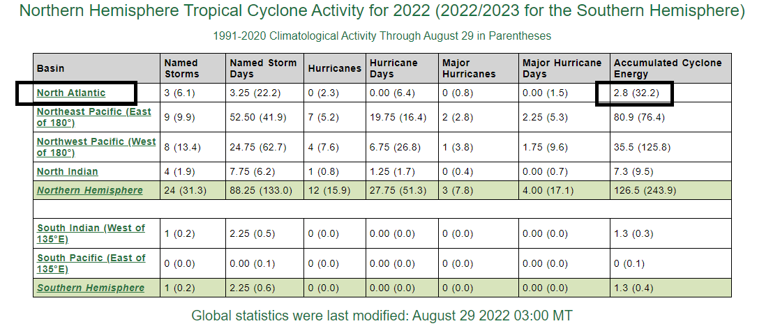
Accumulated Cyclone Energy or ACE is well below-normal across the North Atlantic for this stage of the tropical season and it is across the northern hemisphere as a whole. Data courtesy Colorado State University
Discussion
So far this tropical season overall activity has been running at well below-normal levels in the Atlantic Basin and across the northern hemisphere as a whole. One of the reasons as to why there has been a quiet start to the tropical season include several incursions of dry air masses to the Atlantic Ocean from the Sahara Desert region of Africa. Another has to do with increased wind shear levels in recent weeks over the tropical Atlantic Ocean which acts to suppress development and/or intensification of tropical systems.
One of the best ways to measure overall tropical activity is through a metric known as the “Accumulated Cyclone Energy (ACE)” which factors in both magnitude and duration of systems. As of the 29th August, ACE was far below average in the Atlantic Basin and about half of average across the entire northern hemisphere. Indeed, if there is no named tropical storm in the Atlantic Basin by the end of August which is only a couple days away then that would be the first time since August of 1997 and only the third time since 1961. There have been only three named storms so far in 2022 - Alex, Bonnie and Colin - and this follows the very active years of 2021 and 2020 which featured 21 and 30 named storms respectively.
Currently, there about 4 tropical systems of note across the Atlantic Basin. One system resides over the northwestern Caribbean Sea and it certainly has a chance to ultimately impact Mexico or Texas should it hold together in coming days. Another system is out in the northern part of the central Atlantic and it has little chance of strengthening in coming days. Far to the east, a strong wave has just passed off the west coast of Africa and out into the open waters of the eastern Atlantic and it’ll have plenty of time to intensify as it travels over the warm waters of the tropical Atlantic.

The various forecast tracks of “91L” - a system of concern in the central Atlantic - by the 00Z Euro ensemble model run. Map courtesy ECMWF, BenNollWeather
The fourth system currently on the map is now over the central Atlantic and it may be the one to most closely monitor in coming days as it has a good chance of intensification – perhaps even to named storm status by the end of August – and it will likely head on a course that brings it towards the US east coast. The upper-level pattern of highs and lows across North America is an important factor this time of year in determining the highest threat zones for tropical activity. Indeed, building high pressure across eastern Canada can often open the door for tropical activity to threaten the Gulf of Mexico region or the east coast of the US.
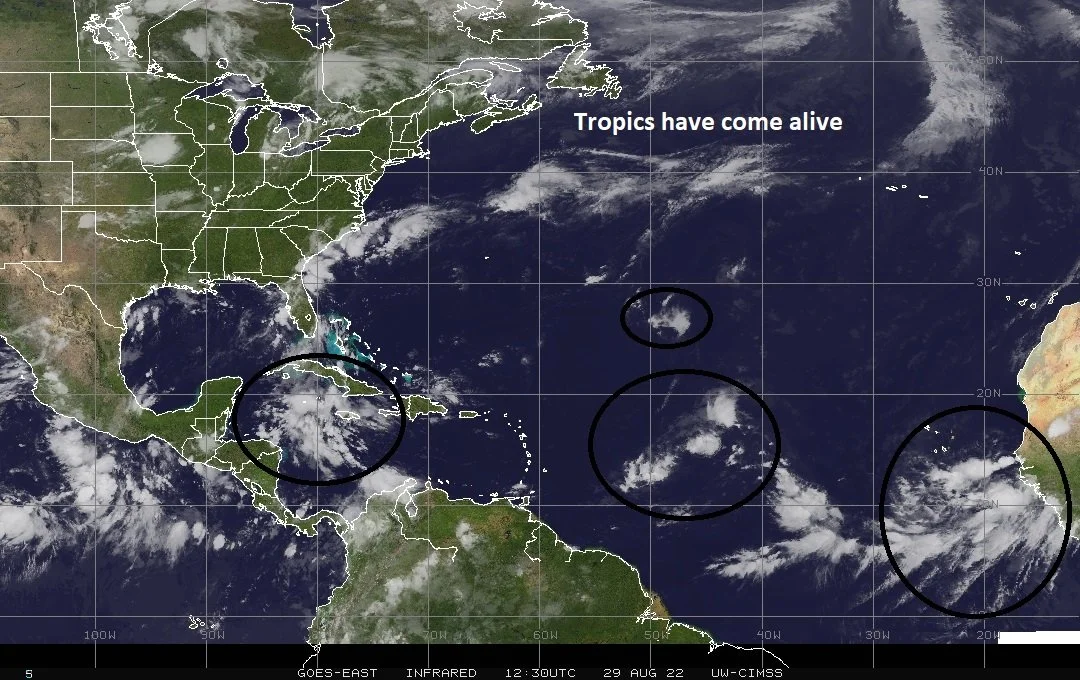
Up to four different tropical waves right now (circled) across the Atlantic Basin with the recent uptick in activity following an extended quiet period. Image courtesy University of Wisconsin/CIMSS; NOAA
There will be many players on the field in the upper part of the atmosphere in coming days making it quite difficult to determine just yet where this tropical system may end up in the next week to ten days or so. One scenario has the tropical system pushing northwest towards the east coast and then curving to the north and east before ever reaching the US mainland as it gets hooked up with an upper-level trough over Canada that could extend out into the northwestern Atlantic. This would be the most favorable outcome and it is quite feasible; however, it is simply too early to write off other possibilities. Another scenario could feature this tropical system to slide a little farther to the south or perhaps slow down some in a weak wind field – both of which could result in it “avoiding” getting picked up by the upper-level trough.
Stay tuned…a lot to monitor over the next week or ten days or so as the tropics have come alive after an extended quiet period.
Meteorologist Paul Dorian
Arcfield
arcfieldweather.com
Follow us on Facebook, Twitter, YouTube
Video discussion: