
2:15 PM | ***California pounding continues, but an upcoming large-scale pattern change suggests an end is in sight…ramifications for the eastern half of the nation as well***
Paul Dorian
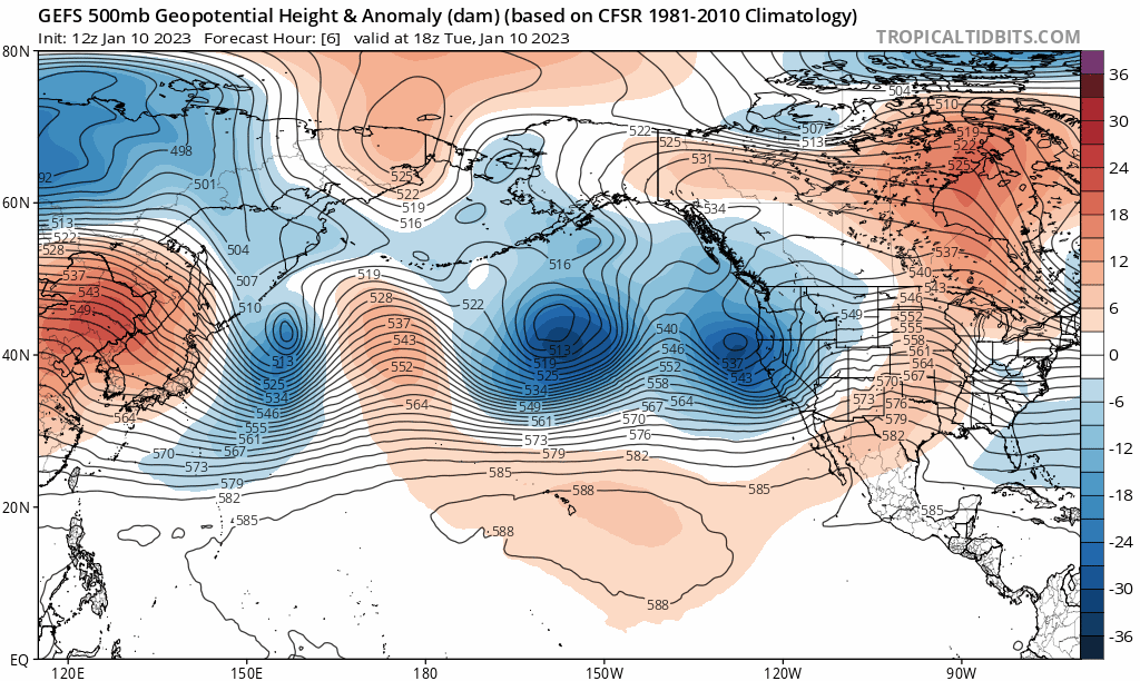
Upper-level high pressure ridging will develop later this month in the region from the US west coast to Alaska (shown in orange) and this development will have big ramifications for California and ultimately to the eastern half of the nation as well. Maps courtesy NOAA, tropicaltidbits.com
Overview
The onslaught of Pacific Ocean storms into California will continue for the next 7-to-10 days with additional “off-the-chart” rainfall and snowfall amounts for the state. A powerful storm continues to affect the Golden State today and another strong storm is likely to arrive this weekend. Looking ahead, a large-scale pattern change looks likely in about ten days across North America featuring a building ridge of high pressure from Alaska to the west coast of the US. This change is likely to bring an end to the stormy pattern in California and it may very well have important ramifications across the eastern half of the nation.

The latest in a series of storms is pounding away at California today with heavy rainfall in low-lying locations and significant snowfall in the Sierra Nevada Mountains. Image courtesy NOAA (GOES-West)
California onslaught continues next 7-10 days
California has been pounded by numerous Pacific Ocean storms in recent days and the latest in the series is bringing heavy rain and snow today to much of the state. Yet another strong storm seems destined to reach California this weekend and a couple more are likely next week. In this very stormy time period during the past few weeks, there have been multiple deep upper-level troughs of low pressure riding along a powerful west-to-east jet stream over the Pacific Ocean.
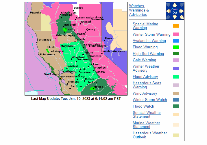
Just about every kind of “weather warning” that can be issued by NOAA is in existence today across California with this latest powerful storm system. Map courtesy NOAA/NWS
Each of these systems has been fueled with plenty of moisture off of the ocean and the result in California has been enormous amounts of rainfall in low-lying locations and incredible snowfall across the higher elevations of the Sierra Nevada Mountains. Given the onslaught of storms in recent days, grounds are very well saturated throughout much of California and this latest storm is exacerbating flooding issues and high winds are resulting in numerous power outages.

The next ten days will feature more excessive rainfall (left) and snowfall (right) in California with “off the chart” amounts. The overall weather pattern should change importantly after that with welcome relief in the Golden State to the stormy pattern. Maps courtesy NOAA, tropicaltidbits.com
Upcoming large-scale pattern change to bring relief to California…ramifications for the eastern half of the nation as well
There are signs for an important change to the overall upper-air pattern across North America later this month that is quite likely to bring welcome relief to the state California and also changes to the eastern half of the nation which has been experiencing generally milder-than-normal weather conditions in recent weeks. High pressure ridging in the upper part of the atmosphere is likely to develop in about ten days or so eventually extending all the way from the west coast of the US to Alaska. This upcoming transition is likely to produce warmer and drier weather in California, Oregon and Washington and similar changes to western Canada.

This forecast map of 500 mb height anomalies for January 23rd by the 12Z GEFS feature ridging from Alaska to the US west coast (shown in orange) and an upper-level trough centered over the eastern half of the nation (shown in blue). This combination will allow for an upper-level wind flow from northwest-to-southeast (indicated with arrow) that will allow for the transport of cold Canadian air masses into the eastern half of the US later this month. Map courtesy NOAA, tropicaltidbits.com
Meanwhile, in the eastern half of the nation, an upper-level trough of low pressure is likely to develop at about the same time the ridging pops up in the western part of the US and Canada. With the combination of the western US/Canada ridging and a trough over the central/eastern US, the upper-level wind flow later this month will be much more conducive to transporting cold air masses from Canada into the eastern half of the nation. In fact, there is the chance that “cross-polar flow” forms which could bring some very cold air from the Siberian side of the North pole into the North American side. This potential change to the overall temperature pattern should also raise the chances for snow in the central and eastern US…largely non-existent in recent weeks.
Bottom line…important changes are on the way for much of North America beginning in about ten days or so.
Meteorologist Paul Dorian
Arcfield
arcfieldweather.com
Follow us on Facebook, Twitter, YouTube
Video discussion: