1:15 PM | ***Active pattern to end shortly in California…active pattern to continue in the central and eastern US***
Paul Dorian

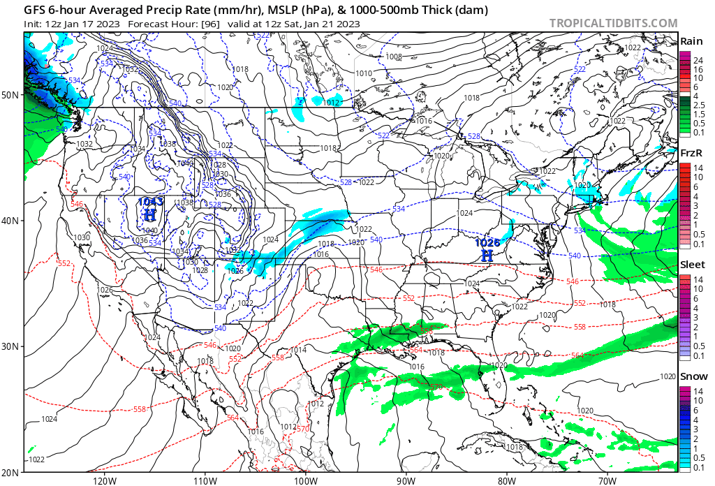
Multiple storms are likely to move from southwest-to-northeast in coming days in the “battle ground” region between upper-level trough over the central states and ridging over the southwestern Atlantic. Maps courtesy NOAA, tropicaltidbits.com (loop of 12Z GFS surface maps run from Saturday, January 21st to Monday, January 30th)
Overview
Another storm will impact California later Wednesday, but this system looks like it will be the last in a series of storms to roll off the Pacific Ocean and into the Golden State. An upper-level ridge of high pressure will build over the eastern Pacific Ocean in coming days and ultimately expand northward into Alaska. This ridge will act as a “protective barrier” to oceanic storms resulting in welcome relief to the waterlogged state.
While the western US may experience a quieter overall weather pattern beginning later this week, it’ll remain quite active across the central and eastern US. In a reaction to the developing ridge over the eastern Pacific Ocean, an upper-level trough of low pressure will form over the central US and Canada. In addition, a ridge of high pressure will intensify over the southwestern Atlantic Ocean in coming days. The corridor region between the upper-level low over the central states and the ridge over the SW Atlantic will become a “battle zone” region likely with multiple storms riding through it from southwest-to-northeast. Snow has been virtually non-existent so far this season in the immediate I-95 corridor region from DC-to-Philly-to-NYC; however, I do believe that the chances will likely increase markedly next week and beyond given the large-scale pattern change that is expected across North America.

The overall weather pattern will feature ridges aloft over the eastern Pacific and southwestern Atlantic and upper-level trough over the central sections of the US and Canada. The region between the central US trough of low pressure and southwestern Atlantic ridge of high pressure will be quite active likely with multiple storms in coming days. Map courtesy ECMWF, tropicaltidbits.com
Details
Yet another in a series of storms will impact California on Wednesday and Wednesday night with another 1 or 2 inches of precipitation across parts of the state. This system looks like it will be the last for awhile as a large-scale pattern change across North America brings upper-level ridging to the eastern Pacific Ocean beginning later this week. This ridge of high pressure will act as a “protective barrier” to oceanic storms bringing welcome relief to the waterlogged Golden State. The drier and milder pattern that develops across California is likely to last through the remainder of the month of January.
This development of high pressure ridging over the eastern Pacific Ocean will have ramifications to the overall upper air pattern across the US and Canada. While the ridge over the eastern Pacific Ocean expands northward to Alaska, an upper-level trough of low pressure will develop over the central sections of the US and Canada and colder-than-normal air will overspread these areas. In addition, ridge of high pressure over the southwestern Atlantic will tend to intensify as we progress through the second half of January. The region between the trough (cold) over the central states and ridge (warm) over the SW Atlantic will become a “battleground” zone and it’ll likely act as a conduit for low pressure systems to move through in a general southwest-to-northeast fashion. In fact, multiple storms are in the cards in the central and eastern US with this unfolding change to the overall upper air pattern.

As upper-level trough develops over the central US and Canada, colder-than-normal air is likely to overspread much of this area by later this month. Map courtesy ECMWF, tropicaltidbits.com
In terms of the potential for snow in the I-95 corridor region from DC-to-Philly-to-NYC where snow has been virtually non-existent this winter season, there will be a couple of favorable factors in this evolving weather pattern. First, a parade of storms seems likely each with plenty of moisture and second, there will be a widespread cold air reservoir centered just to the northwest over the Upper Midwest and Great Lakes. The high pressure ridging over the SW Atlantic certainly can inhibit cold air penetration into the I-95 corridor region from the northwest and there is no doubt that a higher probability for accumulating snow will take place to the north and west. However, I do believe that the chances will likely increase markedly next week and beyond for accumulating snow in the immediate I-95 corridor region given the expected large-scale pattern changes across North America…stay tuned.
Meteorologist Paul Dorian
Arcfield
arcfieldweather.com
Follow us on Facebook, Twitter, YouTube
Video discussion: