1:30 PM | ***Stratospheric temperature update…upcoming storm threats for the Mid-Atlantic/Northeast US***
Paul Dorian

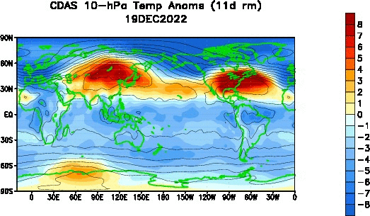
This loop of stratospheric temperatures (10 millibars) during the past 30 days shows warming in the polar region of the Northern Hemisphere (top, center orange/red). Model forecasts of stratospheric temperatures for the next couple of weeks suggest considerable “warming” may take place right near the North Pole with a displacement of the polar vortex to the North Atlantic. Maps courtesy NOAA
Overview
Stratospheric temperatures have risen noticeably during the past couple of weeks in parts of the polar region in the Northern Hemisphere and indications are there will be changes of location of the polar vortex 10-15 days out. In addition, stratospheric warming looks like it could become centered right near or over the North Pole by the time we get into the early part of February. A stratospheric warming event such as this being forecasted could very well result in the displacement of cold air masses from the high latitudes into the middle latitudes sometime later in February.
In the short term, two storm systems are on the way for the Mid-Atlantic/Northeast US in the early and middle parts of next week. As has been the case in January, sufficient cold air for the generation of accumulating snow in the immediate I-95 corridor will be a struggle with both of these upcoming storms. Having said that, it looks like a close call in terms of at least some snow and/or ice in the I-95 corridor during either of these storms and any small change in the overall pattern can make an important difference. Odds do favor accumulating snow in the interior, higher elevation locations of the Mid-Atlantic/Northeast US during each of these storms next week.
Stratospheric temperatures over the next couple of weeks may “warm” considerably over the polar region of the Northern Hemisphere. In the past, this kind of “stratospheric warming” event has led to the displacement of cold air masses from the high latitudes to the middle latitudes. This event can have an impact on US temperatures later in the month of February. Maps courtesy NOAA/GFS
Stratosphere temperature update
Changes in stratospheric temperatures near the polar region of the Northern Hemisphere (NH) can have important impacts to winter season temperatures in the middle latitudes such as in the central and eastern parts of US. Specifically, if the polar vortex (an area filled with low temperatures compared to its surroundings) is weakened or displaced, it could set off a chain of events that unleashes cold air masses from the high latitudes into the middle latitudes. Indeed, temperatures have been rising in the NH polar stratosphere during the past couple of weeks and indications are that significant stratospheric warming will take place right near the North Pole by early February. In addition, the polar vortex is likely to be displaced to a region in the North Atlantic by early February. This unfolding upper atmosphere event needs to be monitored in coming days as it can have an important impact on temperatures across the US later in February and perhaps even into the month of March. For a detailed video discussion on the stratospheric warming process, visit our “Meteorology 101” page.
Upcoming storm threats for the Mid-Atlantic/Northeast US
The region between a developing trough of low pressure (cold) over the central states and ridge of high pressure (warm) over the Southwest Atlantic will act as a conduit for the passage of two storm systems next week from southwest-to-northeast. The first system will bring precipitation to the DC-to-Philly-to-NYC corridor from later Sunday into Monday and a second system is likely to arrive at mid-week. As has been the case all winter, it’ll be a struggle to get enough cold air in place for accumulating snow in the immediate I-95 corridor, but each system still needs to be closely monitored.

The next storm system headed to the Mid-Atlantic/NE US will likely arrive later Sunday and continue into early Monday. Odds favor rain in the immediate I-95 corridor; however, it is a close call and a small change to storm track, for example, could change that outlook importantly. Snow is more favorable during this upcoming early week event in the interior, higher elevation locations of the Mid-Atlantic/NE US. Map courtesy Canadian Met Centre, Pivotal Weather
One of the unfavorable factors for snow in the I-95 corridor early next week is the fact that there may be no strong high pressure system over southeastern Canada. This is usually a requirement for accumulating snow in the urban areas of the I-95 corridor as it can act as an important source of cold air. In addition to lack of high pressure over southeastern Canada, the expected inland storm track for this storm is not favorable for snow in the I-95 corridor. (Note -a secondary storm is ultimately likely to win out as the main system somewhere near the northern Mid-Atlantic coastline later in this event). Having said that, a small change in the storm track to the south and east could have a big impact in the I-95 corridor. In fact, the 12Z NAM computer forecast model has the forecasted storm track farther to the south and east compared to some of the other models and this allows for cold air to penetrate farther into the Mid-Atlantic region from the northwest. In fact, decent snow likely takes place in southeastern PA according to this particular model run (video discussion details the different storm tracks). Bottom line, we still need to closely monitor this initial system next week for any potential changes.

A second storm will push into the Mid-Atlantic/NE US at mid-week and the “rain/ice/snow” line may cut right near the I-95 corridor. One of the key factors could the development of high pressure beforehand across the southeastern part of Canada. Map courtesy Canadian Met Centre, Pivotal Weather
By mid-week, another storm system will pull out of the Lower Mississippi Valley and head northeastward towards the Mid-Atlantic/NE US (right through that boundary zone region between the upper-level low to the north and west and the high pressure ridge to the south and east). A potential key factor in this mid-week event could be the formation of strong high pressure over southeastern Canada beforehand following the passage of a cold frontal system. This is what I’ll be looking for in coming days as I believe there are reasons for this to happen. Some computer forecast models (e.g., NOAA GFS) do not currently have the development of strong high pressure in SE Canada early next week, but I think that general forecast will likely change in coning days. If indeed this high pressure system were to form over SE Canada ahead of the mid-week storm, it could act as an important cold air source; thereby, increasing the chance for some accumulating snow and/or ice in the DC-to-Philly-to-NYC corridor. This event is still several days away and needs to be closely monitored in coming days.
Meteorologist Paul Dorian
Arcfield
arcfieldweather.com
Follow us on Facebook, Twitter, YouTube
Video discussion: