10:45 AM | ***Active pattern brings next storm to the Mid-Atlantic region at mid-week…accumulating snow at the onset in parts of the area***
Paul Dorian
As one system pulls away to the northeast in New England, the seeds for the next system to impact the Mid-Atlantic/Northeast US are being planted in the southwestern states with a strong vorticity max now drifting through that part of the nation. This upper-level feature will spawn the formation of low pressure on Tuesday over Texas and moisture will feed in from the Gulf of Mexico. On Wednesday, this next storm system will push northeastward bringing accumulating snow to the Midwest, interior Mid-Atlantic/Northeast US…even the I-95 corridor can receive some accumulating snow at the onset of the mid-week event. Map courtesy NOAA, tropicaltidbits.com
Overview
As one storm continues to impact the Mid-Atlantic region with lingering rain and snow, the seeds for the next system are rolling through the southwestern states in the form of a vigorous upper-level low. This feature will drift into Texas on Tuesday and help generate surface low pressure and abundant moisture will feed into the system from the Gulf of Mexico. On Wednesday, this surface low pressure system will push northeastward with its large moisture field advancing to the Midwest and Mid-Atlantic. Another key player in the upcoming mid-week event will be strong high pressure that forms over southeastern Canada. This system will anchor an air mass that will be cold enough for widespread accumulating snow across the Midwest, interior Mid-Atlantic and Northeast US. There is likely to even be some accumulating snow at the onset in portions of the I-95 corridor of the Mid-Atlantic on Wednesday before the precipitation ultimately changes to plain rain.
Snow could break out on Wednesday morning in the Mid-Atlantic region to the north of the PA/MD border with some accumulations possible before a changeover to rain. A key player in the mid-week event will be high pressure over southeastern Canada (circled) which will - at least initially - act as an important anchor for cold air in the Midwest/Mid-Atlantic/NE US. Map courtesy NOAA, tropicaltidbits.com
Mid-week storm threat
As has been the case through much of January, cold air has been a struggle in the I-95 corridor with respect to the formation of snow. Yesterday’s low pressure system resulted primarily in plain rain in the DC-to-Philly-to-NYC corridor as temperatures were above freezing in most locations during much of Sunday and Sunday night. A changeover to snow has taken place across parts of eastern PA and New Jersey today as colder air filters into the area on the back side of the departing low pressure system. This can result in grassy accumulations in lower lying spots (e.g., southeastern/east-central PA) and perhaps a couple inches of snow in higher elevation locations (e.g., northeastern PA). Winds will pick up dramatically this afternoon from a northwesterly direction with gusts possible to 35 mph or so in the DC-to-Philly-to-NYC corridor.
After the changeover from snow to rain takes place later Wednesday, there can actually be some heavy rain along the I-95 corridor. Map courtesy NOAA, tropicaltidbits.com
This active weather pattern will bring another storm to the Mid-Atlantic region at mid-week. One difference with this upcoming setup and the current one that is now winding down will be likelihood for strong high pressure to be positioned over southeastern Canada by the time the mid-week storm arrives. From this location, this high pressure system will be the anchor to an air mass that should be cold enough for widespread accumulating snow across the Midwest and interior Mid-Atlantic/Northeast US. In addition, there should be enough cold air around at the onset of the mid-week storm for accumulating snow to fall in parts of the Mid-Atlantic’s I-95 corridor. The best chance for accumulating snow on Wednesday will likely be in areas to the north of the PA/MD border and there can be a couple of inches in the zone from Philly to NYC. To the south of the Mason-Dixon Line, the far northern and western suburbs of DC can see a brief period of snow or a wintry mix at the onset with small grassy accumulations possible.
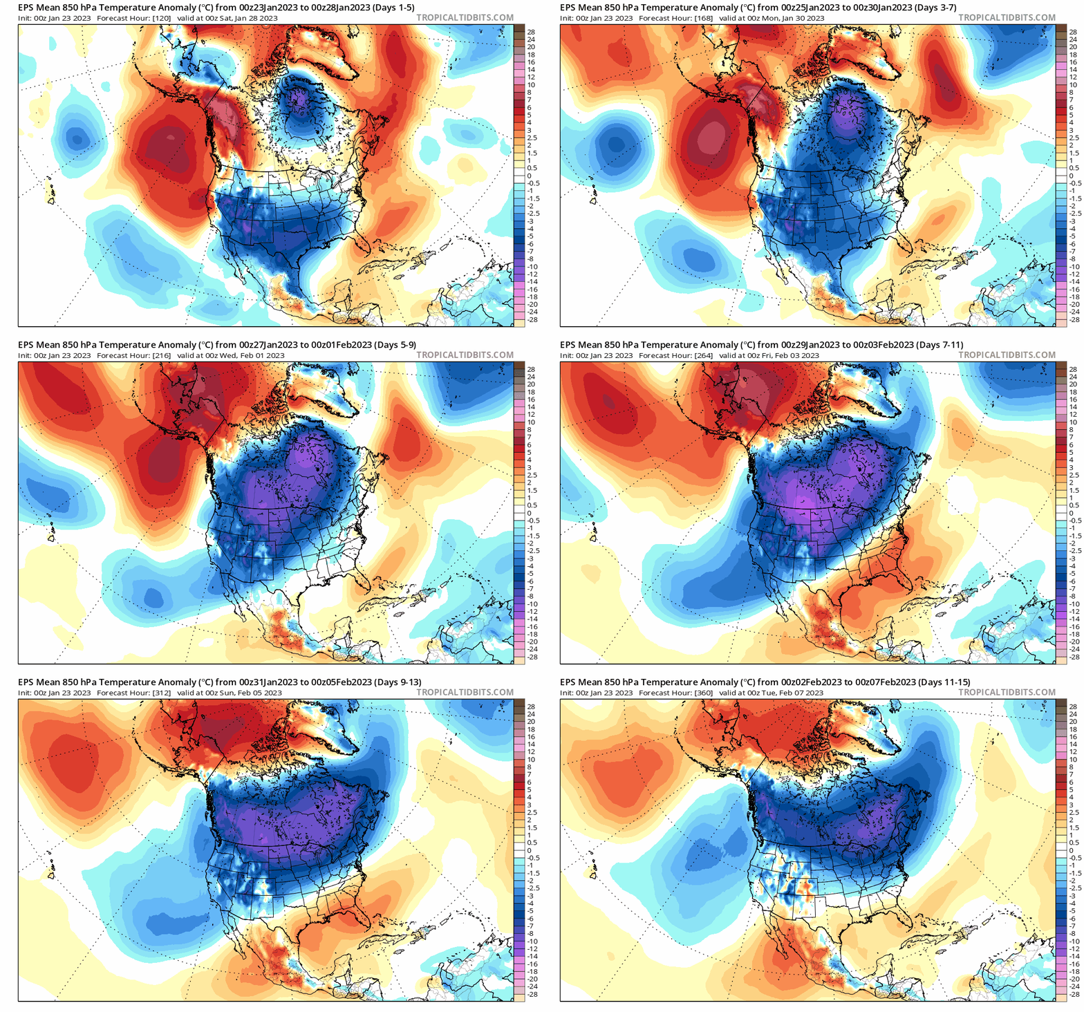
Odds favor a widespread colder-than-normal air mass next week and into early February across much of the northern US. Maps courtesy ECMWF, tropicaltidbits.com
By later Wednesday, as the primary low pressure system heads toward the Great Lakes, enough mild air will push into the I-95 corridor to cause a changeover to plain rain throughout the DC, Philly and NYC metro regions and some of the late day and nighttime rain can fall heavily at times. Behind the storm, NW winds will increase in strength on Thursday and a chilly air mass will push in from the Great Lakes and stick around until the weekend. Looking ahead, it certainly appears that widespread colder-than-normal air will push into the northern US from central Canada and very likely spread all the way to the Mid-Atlantic region later this month and into early February.
Meteorologist Paul Dorian
Arcfield
arcfieldweather.com
Follow us on Facebook, Twitter, YouTube
Video discussion:


