
10:50 AM | ***Some snow is possible at the onset on Wednesday north of PA/MD border, but it turns into a rain event...some of the rain can get heavy...some amazing cold in China, Russia***
Paul Dorian

Snow (in blue) will extend from the Midwest to the interior Mid-Atlantic and Northeast US at mid-day on Wednesday. Map courtesy NOAA (12Z GFS), tropicaltidbits.com
Overview
A significant winter storm is developing today over Texas and this moisture-laden system will push northeastward over the next 24 hours bringing significant snowfall all the way from Texas to the Midwest. In the Mid-Atlantic region, snow is likely to break out on Wednesday morning in areas to the north of the PA/MD border and there can be some minor accumulations before a changeover to rain later today as milder air surges northward along the coast.
Looking ahead, widespread colder-than-normal air is going to push into the northern and western US early next week and it’ll likely spread into the Mid-Atlantic/Northeast US by late next week. Whether or not this change to colder-than-normal conditions is sustained in the Mid-Atlantic/Northeast US after next week will largely depend on the stubborn high pressure ridge aloft over the southwestern Atlantic/Southeast US. Elsewhere, there has been some amazing cold on the other side of the North Pole with the lowest temperature ever recorded in China on Monday and this follows some tremendous cold last week in Russia (Siberia). This frigid air is now spreading to the Korean Peninsula and on the way to Japan where there can also be some all-time low temperatures.

A significant winter storm will spread a swath of accumulating snow from Texas to the Northeast US over the next 72 hours. Map courtesy NOAA, tropicaltidbits.com
Significant winter storm and a severe weather catalyst
Strong low pressure will form over Texas today and it’ll become a snowmaker for northern Texas and a culprit for severe weather including possible tornadoes in the storm’s warm sector across central/southeastern Texas and the northern Gulf coast. On Wednesday, this system pushes to the northeast and becomes a significant winter storm for the Midwest, interior Mid-Atlantic and much of Northeast US. The system will have plenty of moisture available to it as it pushes northeastward and right into the teeth of a cold air mass anchored by high pressure over southeastern Canada. A band of significant accumulating snow will extend from Texas beginning today to the Midwest on Wednesday with 6-12 inches on the table in many spots.

Widespread colder-than-normal air is depicted to encompass much of the US and Canada by late next week. Whether or not this kind of cold will be sustained will largely depend on high pressure ridging aloft over the SE US/southwestern Atlantic. Map courtesy Environment Canada (12Z GEPS), weathermodels.com
As the moisture expands eastward, snow is likely to break out across much of Pennsylvania and New Jersey later Wednesday morning and perhaps even as far south as northern Maryland for a brief time. Ultimately, enough milder air will push northward along the coast to bring about a changeover to rain in the Mid-Atlantic’s I-95 corridor. In term of accumulations, in the Philly metro region, some of the far northern and western suburbs can receive a coating to an inch or so before the changeover to rain, but the city of Philadelphia will likely be all wet. As much as 2-4 inches of snow is possible in the Lehigh Valley and Pocono Mountains, but even these upstate areas will see a changeover to rain. In areas south of the Mason-Dixon Line, there can be a very brief period of snow or a wintry mix in some of the far northern and western suburbs of DC before the changeover.
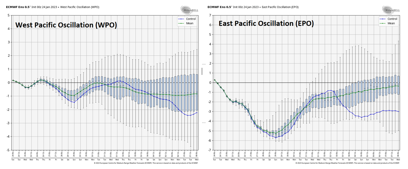
These two Pacific Ocean teleconnection indices (WPO, left; EPO, right) trend into negative territory in coming days which is often a harbinger of colder-than-normal weather for the central and eastern US during winter seasons. The high pressure ridging over the SE US and southwestern Atlantic may have something to say about the potential cold in the Mid-Atlantic/NE US. Maps courtesy Weather Bell Analytics, NOAA
Widespread cold late next week across US/Canada…some amazing cold in China, Russia and headed to Japan
Looking ahead, it certainly appears that widespread colder-than-normal air will push into the northern and western US early next week and it’ll likely spread all the way to the eastern seaboard by late next week. Some teleconnection indices support the notion of a colder pattern once again across the US with the Eastern Pacific Oscillation (EPO) and Western Pacific Oscillation (WPO) trending into “negative” territory as we go through the remainder of the month. This kind of trend in the EPO and WPO suggests the “warming effect” in the US of a west-to-east Pacific Ocean jet stream will diminish in coming days. However, a contrary signal for sustained cold in the Mid-Atlantic and Northeast US is the high pressure ridge aloft that has been reluctant to give up any ground over the SE US/SW Atlantic.

The lowest temperature ever recorded in China took place earlier this week when the northern city of Mohe bottomed out at -63.4 degrees (F). Graphic courtesy ScottDuncanWx
Elsewhere, the cold has been amazing in China and Russia. In fact, China recorded its lowest temperature ever on Sunday, January 22nd by bottoming out at -63.4 degrees (F) in the northernmost city of Mohe. While this city is typically quite cold, the chill over the weekend was exceptional some 35 degrees (F) or so below-normal. This all-time China low temperature surpassed the previous one of -62.1 degrees (F) set back in 1969. This frigid air mass is now spreading southeast into the Korean Peninsula and is headed to Japan where some all-time low temperatures may be set.
The extreme chill in China comes on the heels of some historic cold in Siberia earlier this month. Temperatures fell to as low as -80.9 degrees (F) on January 18th in the village of Tongulah which was the lowest recorded in Russia since 2002 and the coldest in the month of January since 1982. What’s more, residents on the eastern Siberian village of Essey are adamant that their thermometers plunged to -103 degrees (F). If confirmed (and that is unlikely), this would actually be a worldwide low temperature record for any location outside of Antarctica.
Meteorologist Paul Dorian
Arcfield
arcfieldweather.com
Follow us on Facebook, Twitter, YouTube
Video discussion: