
2:30 PM | ***Onslaught in California continues with additional storms next several days…a look at upcoming threats in the Mid-Atlantic/Northeast US***
Paul Dorian

A parade of storms will cross the Pacific Ocean during at least the next 7-to-10 days and slam into California with additional excessive rainfall and substantial snowfall amounts. Maps courtesy NOAA, tropicaltidbits.com
Overview
The onslaught of Pacific Ocean storms into California will continue for at least the next 7-to-10 days with “off-the-chart” rainfall and snowfall amounts. After slamming into California, these storms have traveled across the country making for an overall active weather pattern across much of the US. In some cases, the impact has been large such as with the severe weather outbreak earlier this week in the Lower Mississippi and Tennessee Valleys and in other cases, systems have weakened considerably by the time they have reached the eastern states. We’ll examine upcoming threats in the Mid-Atlantic/Northeast US with small snow accumulations possible as early as Sunday night and perhaps the greatest chance for a strong storm system coming in the period of January 13-15th.

Rainfall amounts (left) and snowfall amounts (right) during the next 7-to-10 days will be “off the charts” in California. More than a foot of rain can accumulate in this next week to ten days in low-lying sections of the Golden State and nearly 100 inches is predicted by the 12Z GFS model run in the Sierra Nevada Mountains of eastern California. Maps courtesy NOAA, tropicaltidbits.com
California onslaught continues
The state of California has been pounded by numerous Pacific Ocean storms in recent days and multiple storms are in the offing during at least the next 7-10 days. These storms are bringing excessive rainfall amounts to low-lying coastal sections and incredible snowfall amounts to the higher-elevation Sierra Nevada Mountains of eastern California. Indeed, preliminary reports of snowfall amounts in the mountains of eastern California indicate the snowpack could be at the highest level seen during the last 40 years in some spots. The next several days could feature rainfall totals of more than a foot in some low-lying elevations and massive snowfall amounts of 10 feet or more in the Sierra Nevada Mountains.
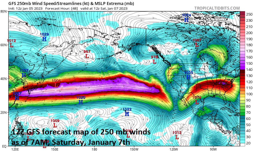
A main contributing factor in the push of moisture into California has been a relentless upper-level jet (at 250 millibar level) and this pattern should continue in coming days. Map courtesy NOAA, tropicaltidbits.com
The latest in a series of storms continues to pound away at the state today with rain in low-lying areas and snow in the mountains. This overall pattern is certainly helping to alleviate drought conditions with a replenishment of water in lakes and reservoirs and the “off-the-chart” snow in the Sierra Nevada Mountains will be quite valuable come summertime. Snow melt in the Sierra Nevada Mountains during the summer season is a valuable source of water and there will be plenty stored up with this on-going very active weather pattern.

While there are some threats coming to the Mid-Atlantic/Northeast US during the next several days including later Sunday into early Monday, perhaps the greatest will come in the time period of January 13-15th. Many signs point to strong low pressure near the southeast US coastline in this time period with strong high pressure over southeastern Canada…maybe, just maybe, the best chance for snow we’ve seen in awhile for the Mid-Atlantic/NE US. Map courtesy ECMWF, tropicaltidbits.com
Upcoming threats for the Mid-Atlantic/Northeast US
Several systems that have originated over the Pacific Ocean have traveled across the country creating some havoc along the way, but in some case, substantial weakening took place before they reached the eastern states. One such example will take place later tonight and on Friday as a weakening system will only have the strength to produce scattered rain and/or snow showers in the Mid-Atlantic/Northeast US after having generated much more significant precipitation in the western states. On Saturday, another system will be on the move across the Midwest and this low pressure area looks like it’ll hold together enough to generate some snow and/or rain in the Mid-Atlantic region late Sunday into early Monday, but its impact looks like it’ll be somewhat limited based on two counts. First, the strength of the low pressure system will not be all that great and second, the amount of cold air around will be nothing to write home about. Having said that, a small accumulation of a coating to an inch or two is possible in many suburban locations of the DC-to-Philly-to-NYC corridor by early Monday morning from this late weekend system.
By the middle of next week, yet another system could become quite strong; it currently looks like it’ll stay pretty far to the southeast of the Mid-Atlantic region moving to a position off the SE US coastline…still needs to be monitored though in coming days. Perhaps the best indications for a strong storm system are for the end of next week or during the subsequent weekend…specifically, in the time period of the 13-15th. It is at this time that upper-level low pressure - with its origins over the Pacific Ocean - may move to near or over the southeast US coastline and intensify. Meanwhile, surface high pressure may form over the southeastern part of Canada with upper-level ridging intensifying over the Hudson Bay region of Canada. This kind of a pattern can result in a cold enough air mass for snow in the Mid-Atlantic/Northeast US, but as has been the case in recent days, it will be a struggle…stay tuned.
Meteorologist Paul Dorian
Arcfield
arcfieldweather.com
Follow us on Facebook, Twitter, YouTube
Video discussion: