9:30 AM | **Pacific Ocean-to-Gulf of Mexico "tropical hand-off"…yet another weekend rain event Mid-Atlantic region**
Paul Dorian

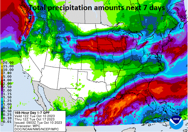
Two big weather events in coming days will result in copious amounts of total rainfall for much of the nation. The first weather event will feature a west-to-east trek across the northern states of a deepening upper-level trough of low pressure. The second weather event will feature the formation of a tropical low pressure system over the Gulf of Mexico. The northern US system will result in a wide swath of heavy rainfall all the way from the central Plains to the Mid-Atlantic region and the second (tropical) system will bring heavy rainfall to the northern Gulf region and other portions of the SE US. Map courtesy NOAA, tropicaltidbits.com
Overview
Two big weather stories over the next several days will include a Pacific Ocean-to-Gulf of Mexico “tropical hand-off” and yet another weekend rain event is in the cards for the Mid-Atlantic region. Hurricane Lidia will head into western Mexico later today and some of its tropical moisture will make it across Mexico at mid-week giving a boost to a tropical wave sitting over the southwestern Gulf of Mexico. Surface low pressure with a Pacific Ocean-to-Gulf of Mexico tropical connection will form by later tomorrow over the western Gulf and then spread some heavy rainfall across the northern Gulf/Southeast US as it takes a path to the east-to-northeast.
Meanwhile, a deepening upper-level low pressure system will cross the nation from west-to-east in coming days and set off the development of surface low pressure over the Ohio valley by week’s end. This primary or initial low will then give way to a secondary low pressure system likely to form early this weekend along the Mid-Atlantic coastline. The result will continue a recent trend in the Mid-Atlantic region with some weekend rain and very cool conditions featuring a persistent onshore flow of air.
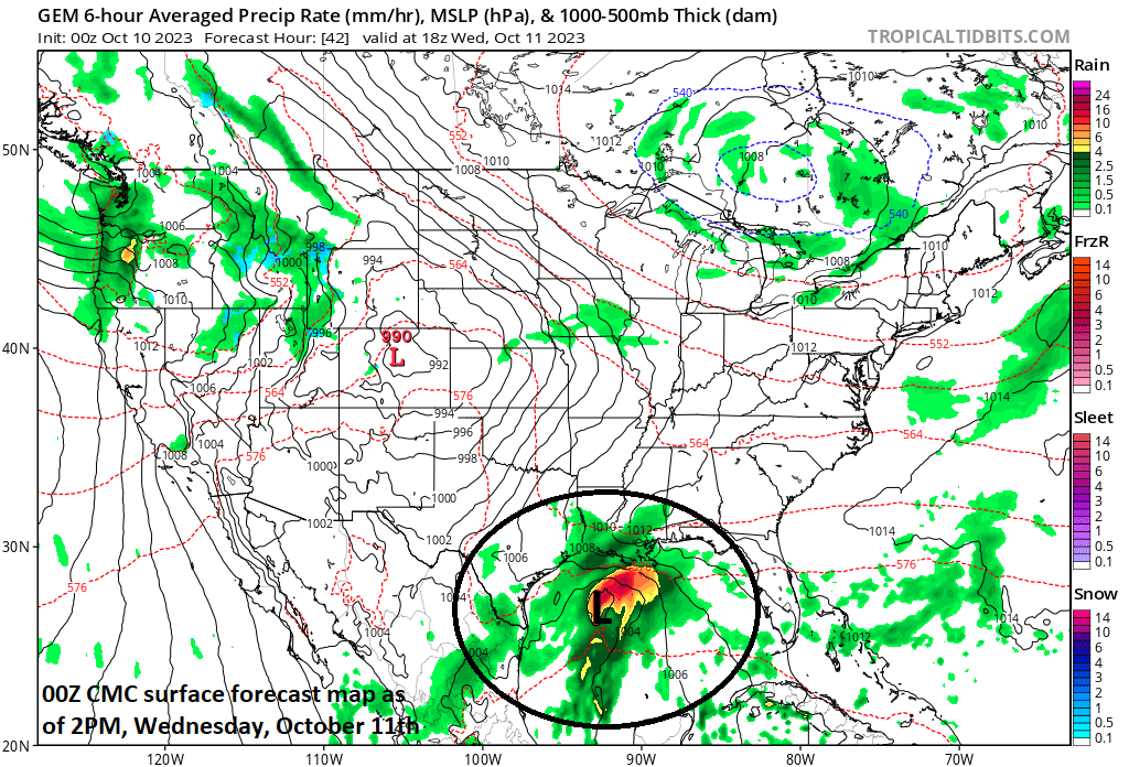
Lots of tropical moisture from an eastern Pacific Ocean system (Hurricane Lidia) will push across Mexico during the next 24 hours or so and aid in the formation of a western Gulf of Mexico tropical system at mid-week. This Gulf of Mexico low pressure system will bring some heavy rainfall across the northern Gulf region and southeastern states as it treks east-to-northeast in coming days. Map courtesy NOAA, tropicaltidbits.com
Pacific Ocean-to-Gulf of Mexico “tropical hand-off”
Lidia has become a hurricane in the eastern Pacific Ocean with maximum sustained winds of 85 mph and it will push into western Mexico from later today into tonight. Some of this moisture will push into the Gulf of Mexico and give a boost to a tropical wave that has been sitting over the southwestern Gulf of Mexico. Whether or not the Gulf of Mexico tropical system is named by NOAA’s National Hurricane Center remains to be seen, but it’ll very likely result in some heavy rainfall across the northern Gulf region and other parts of the southeastern US. The heavy rain threat in coming days will extend all the way from southeastern Louisiana to Georgia and southern South Carolina. This tropical system will continue on a general east-to-northeast track and exit off the Southeast US coastline by later Thursday or early Friday. It does not look like this Gulf tropical system will ride up along the eastern seaboard, but rather push out into the open warm waters of the southwestern Atlantic where it is likely to intensify.
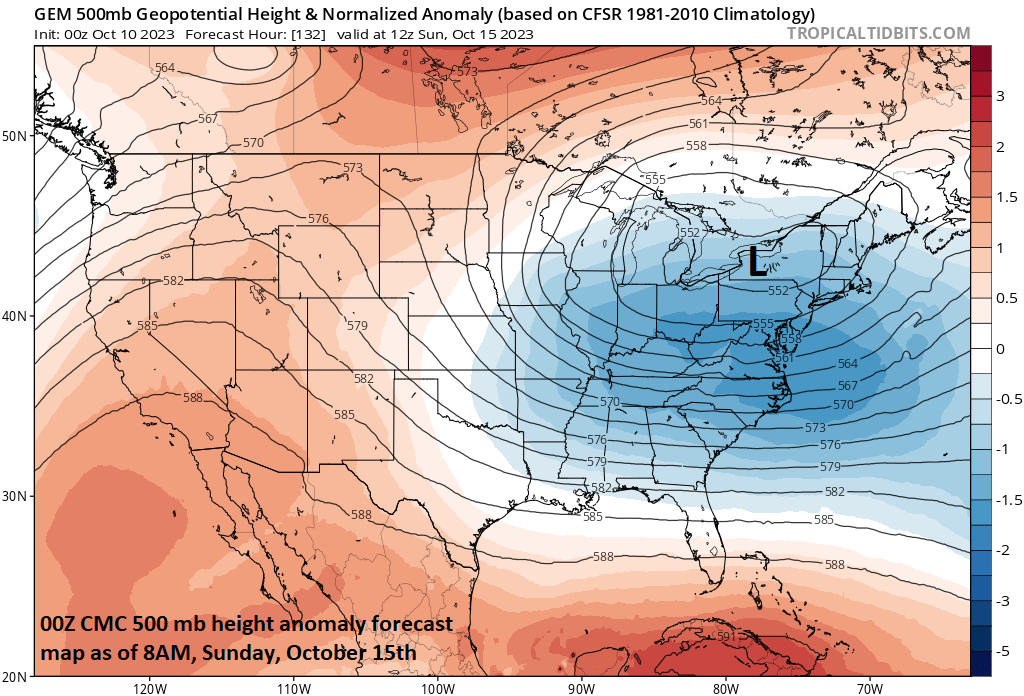
A deepening upper-level low pressure system will trek east across the nation in coming days and it’ll be the catalyst for the development of an Ohio Valley surface (primary) low pressure and then the formation of a secondary low pressure center near the Mid-Atlantic coastline by early this weekend. Map courtesy NOAA, tropicaltidbits.com
Weekend rain event in the Mid-Atlantic region
The weather for the next few days looks rather quiet in the Mid-Atlantic region with high pressure to the south taking control, but this pattern will change significantly by the time we get to the upcoming weekend. Later in the week, a strengthening upper-level low pressure system will trek east across the central states at the same time a frontal boundary zone pushes from west-to-east. Low pressure will form along this incoming frontal system and push into the Ohio Valley by the end of the week. At this point, this primary or initial low pressure system is likely to give way to the development of a secondary low pressure near the Mid-Atlantic coastline by the early part of the upcoming weekend.
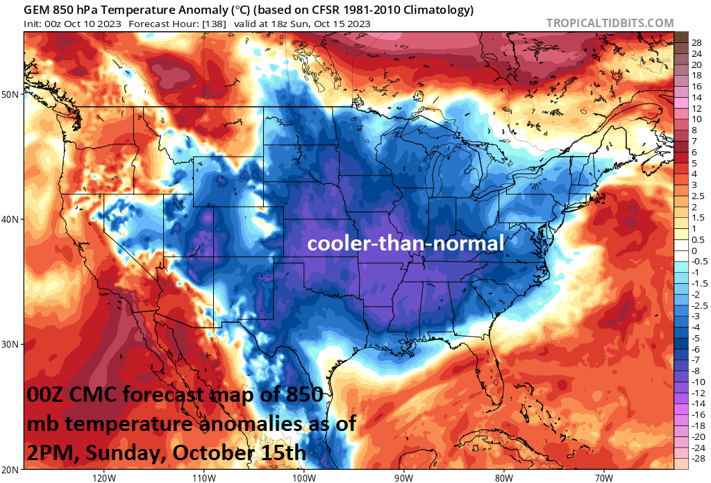
As this surface low strengthens along the coast early this weekend, an onshore flow of air will develop (low-level northeasterly winds) and temperatures will tend to drop to well-below normal levels (sound familiar). In addition to the cool down, the storm’s precipitation field is likely to blossom raising the possibility of a soaking rainfall on Saturday in much of the Mid-Atlantic region. With the slow departure of the upper-level low, the rain and cool temperatures are likely to hang on for awhile well into the day on Sunday across much of the DC-to-Philly-to-NYC corridor. After that - and as has been the pattern in recent weeks - the weather will slowly improve during the early part of the new work week….we’ll see what the weekend of the 21st/22nd brings to the Mid-Atlantic.
Meteorologist Paul Dorian
Arcfield
arcfieldweather.com
Follow us on Facebook, Twitter, YouTube
Video discussion: