***On-going stratospheric warming event takes it to a new level…an active weather pattern with multiple threats to monitor***
Paul Dorian

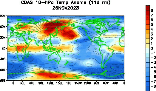
Stratospheric warming over the northern hemisphere polar region (top of plots) actually got underway in late November and will rise to new heights over the next ten days or so. Maps courtesy NOAA
Overview
A northern hemisphere stratospheric warming event that began during the latter part of November will rise to new levels within the next ten days or so and this could have important ramifications on temperatures across the central and eastern US from later January into February. Temperatures at the stratospheric level of 10 millibars will climb dramatically over the next ten days or so from about -70 degrees (Celsius) to about -25 degrees (Celsius) as warming aloft intensifies over the polar region of the northern hemisphere. The “polar vortex” that typically resides near or over the North Pole during this time of year will become displaced and “stretched” in coming days and this could unleash some high latitude cold air masses into the middle latitudes by the time we get into later January and February. In the near term, the weather pattern will be quite active across the eastern states with multiple systems to monitor during the next couple of weeks and temperatures will return to more seasonal levels.

Big-time temperature changes over the North Pole in the next ten days or so with a dramatic rise in temperatures. This stratospheric warming event can have a big impact on temperatures across the central and eastern US from later January into February. Maps courtesy NOAA
An Active Weather Pattern
An active upper-level pattern across North America will include multiple threats to monitor in coming days that may have an impact on parts of the eastern US. At the same time, the mild conditions of this week will give way too more seasonable conditions which will put the possibility of snow back on the table for the Mid-Atlantic region. The first low pressure system that can impact the Mid-Atlantic region will come this Friday and it looks rather weak overall with limited moisture. The next threat looks like a “clipper-like” system that will drop southeastward across the Great Lakes by early next week. There is third system possible for later next week along the east coast, and finally - and looking way ahead - there could be another system to deal with two or three days after that around January 6th or 7th.

Multiple upper-level lows will push into the eastern states in coming days and while none is definitive at this point in time, each one will have to be monitored. The first (weak) system arrives in the Mid-Atlantic region this Friday/Saturday…another clipper-like system is possible early next week…a third is possible later next week along the east coast, and finally, there may be a fourth to deal with a few days after that. Maps courtesy NOAA, tropicaltidbits,com
Today’s soaking rainfall in the Mid-Atlantic region is being produced with strong upper level low pressure over the middle of the nation and this system will tend to only slowly “rotate” to the eastern states over the next 48 hours or so. As a result, another surface low (weak) will spin eastward and bring some precipitation to the Mid-Atlantic from Friday into Saturday, but it has limited moisture levels.
A second clipper-like system may push southeastward across the Great Lakes by early next week and again, there will only be marginally cold air around so indeed if it comes to fruition, it’ll be a battle between rain and snow in much of the Mid-Atlantic region. Later next week, there is the chance for a third system to have an impact in the eastern US and this one may have more cold air to work with enhancing the chance of snow in the Mid-Atlantic region. Finally – and certainly we are now within the “speculation” time period – there may be a fourth system to deal with in the eastern states two or three days after that around January 6th or 7th…plenty of time to deal with that possibility.
Stratospheric Warming Event
A stratospheric warming event that got underway in late November across the northern hemisphere is about to take it to another level with even more significant warming near or right over the North Pole. This intensification of the warming over the polar region over the next ten days or so will likely see a dramatic rise in temperatures from about -70 degrees (C) to about -25 degrees (C).
Stratospheric warming is a naturally occurring phenomenon that takes place in the northern hemisphere every couple of winters or so. Typically, temperatures are very cold in the stratosphere over the polar region during the northern hemisphere winter, but periodically, warming takes place which can disrupt the polar vortex. In some cases, the polar vortex is displaced from its location to a position farther from the pole; in other cases, it is broken up into multiple pieces or simply weakened significantly.
In these cases where the polar vortex is disrupted due to stratospheric warming, cold air masses that are usually confined to the high latitudes can be unleashed onto the middle latitudes and this could very well be on the table for the central and eastern US down the road. Typically, the impact at the ground-level of a stratospheric warming event can take several weeks to unfold; therefore, the impact here may be from later January into February. And if history is any guide, a stratospheric warming event of this magnitude, can ultimately result in some extreme cold…something we’ll monitor in coming weeks.
Meteorologist Paul Dorian
Arcfield
arcfieldweather.com
Follow us on Facebook, Twitter, YouTube
Video discussion: