
2:00 PM | *Battle brewing in next couple weeks between persistent Southeast US high pressure ridge and developing high-latitude blocking over Greenland/Northeast Canada*
Paul Dorian
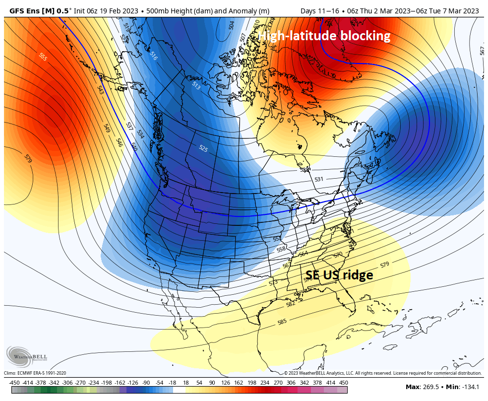
High-latitude blocking is likely to develop across Greenland/Northeastern Canada as we turn from February into March and this new player on the field could battle the persistent Southeast US ridge for dominance in the eastern states. Map courtesy NOAA, Weather Bell
Overview
The overall weather pattern across the eastern US has been active in recent weeks and there is reason to believe it’ll remain quite energetic over the next couple of weeks. In fact, the Mid-Atlantic/Northeast US can become quite a “battle zone” region with the development in coming days of high-latitude blocking across Greenland/Northeastern Canada at the same time high pressure ridging persists over the Southeast US. There will be times when the SE US ridge shows its strength with warm air surging northward into the Mid-Atlantic region and other times in which the high-latitude blocking flexes its muscle resulting in cold air dropping southward from Canada into the northeastern part of the US.

Two teleconnection indices known as the North Atlantic Oscillation (NAO, top) and Pacific North America (PNS, bottom) suggest high-latitude blocking may form over Greenland/NE Canada at the same time high pressure ridging persists over the SE US. Data courtesy NOAA
Active weather pattern
The overall weather pattern across the nation has been active in recent weeks with substantial snowfall in some areas including the Sierra Nevada Mountains of eastern California and much of the Northern Plains, Upper Midwest and northern New England. In fact, these same areas that have been hit hard with accumulating snow in recent weeks will likely be hit again during the upcoming 10-day time period. In the Mid-Atlantic/Northeast US, the overall weather pattern has been quite active as well in recent weeks and a battle is brewing in the atmosphere that will likely result in a continuation of an energetic pattern during the next couple of weeks. Anomalously strong high pressure ridging has persisted in recent weeks centered primarily over the Southeast US. This system is a critical reason as to why the Mid-Atlantic/Northeast US has enjoyed milder-than-normal conditions on average during much of January and February. It appears this system will stick around in coming days and there is some supporting evidence for this from a teleconnection index known as the Pacific-North America (PNA) which trends in “negative” territory as we head into March and this pattern is usually correlated with a strong SE US ridge. This ridge of high pressure will show its strength at times this week in the Mid-Atlantic with, for example, a surge of warm air pushing northward on Thursday. In fact, places like Washington, D.C., could experience temperatures in the 70’s on Thursday…way above-normal for late February and perhaps a record-breaker kind of a day in many spots.

More active weather will bring substantial snowfall over the next 10 days in places that have been hit hard this winter season such as the Sierra Nevada Mountains of eastern California, Northern Plains, Upper Midwest and northern New England. Map courtesy Canadian Met Centre/tropicaltidbits.com
A new player on the field in coming days will be high-latitude blocking/higher pressure than normal which is likely to develop over Greenland/Northeastern Canada. Supporting evidence for this new twist is a teleconnection known as the North Atlantic Oscillation (NAO) which drops into “negative” territory in coming days and this is generally correlated with higher heights and pressure than normal across Greenland and the northeastern part of Canada which, in turn, is more favorable for cold air intrusions into the northeast states.

Snowfall has been substantial this winter season across the Sierra Nevada Mountains of eastern California, Northern Plains, Upper Midwest and northern New England. Map courtesy NOAA
Short-term precipitation threats in Mid-Atlantic/NE US
The upcoming battle between high-latitude blocking to the north and high pressure ridging to the south will likely result in an “up and down” temperature pattern in the Mid-Atlantic/Northeast US as we head from February into March. In fact, this next few days will present some big differences in temperatures from one day to the next and one such example will take place between Wednesday and Thursday. On Wednesday, it’ll turn quite chilly in the Mid-Atlantic region/NE US following the passage of a cold frontal system and this could set the stage for some wintry precipitation at mid-week at least in the northern Mid-Atlantic (e.g., upstate PA, interior NW NJ, NYC) where some ice/snow can mix in with rain with the approach of a warm front.
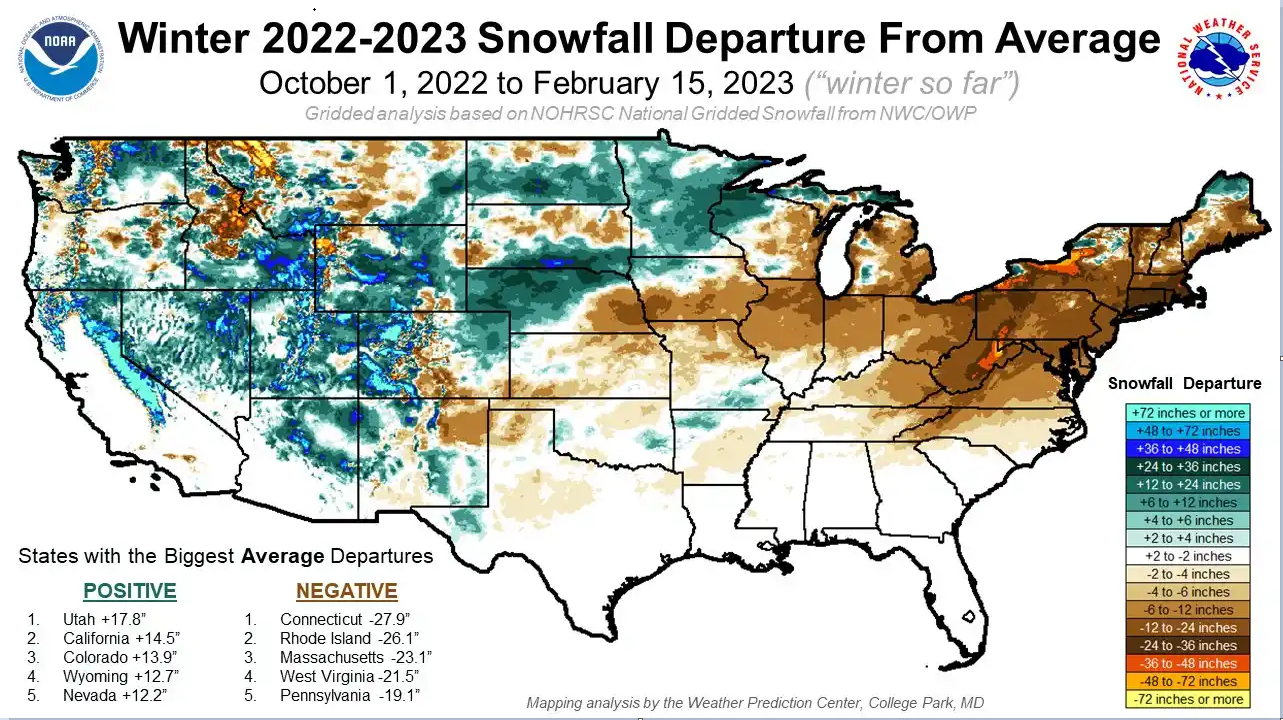
This map shows the departures from normal for snowfall so far this winter season. Lots of below-normal snowfall across the Mid-Atlantic/NE US and above-normal from eastern California to the Upper Midwest. Map courtesy NOAA/WPC
On Thursday, following the passage of the warm front temperatures could surge in the southern Mid-Atlantic region where, for example, Washington, D.C. could experience temperatures in the 70’s. Colder high pressure returns to the Mid-Atlantic/NE US by the end of the work week and this can set the stage for some snow on Saturday in parts of the Mid-Atlantic with low pressure headed to near the Mid-Atlantic coastline.
Meteorologist Paul Dorian
Arcfield
arcfieldweather.com
Follow us on Facebook, Twitter, YouTube
Video discussion: