
2:00 PM | ***Record-breaking warmth in the East…bitter cold in much of the western half of the nation…blizzard warnings in of all places southern California***
Paul Dorian

While the East is experiencing record-breaking warmth, bitter cold air grips much of the western half of the nation. Map courtesy NOAA, tropicaltidbits.com
Overview
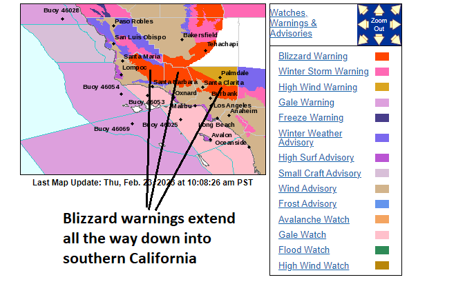
The country is sharply divided today in terms of temperatures with record-breaking warmth in the East and bitter cold in much of the western half of the nation. In addition to the cold, accumulating snow is falling in a swath from the Upper Midwest to northern New England from a storm system that has impacted a large part of the nation in recent days. Snow is also falling across many western states and blizzard warnings have been posted in of all places the southern part of California. In fact, for the first time ever, blizzard warnings have been issued by the San Diego office of NOAA’s National Weather Service for the San Bernardino Mountains.

Record or near-record high temperatures exist today across the Carolinas and southern Mid-Atlantic. Map courtesy coolwx.com
Record-breaking warmth in the East
Temperatures have soared to the 70’s and 80’s in much of the eastern US today with record highs on the table in many spots from the Carolinas to the southern part of the Mid-Atlantic region including the Washington, D.C. metro area. High pressure has shifted off the east coast and this has allowed a low-level flow of warm air to surge northeastward all the way into southeastern Pennsylvania and southern New Jersey. Just to the north, however, east-to-northeast flow low-level has prevented the northward push of this warm air surge to reach the northern Mid-Atlantic with places like Allentown (PA) and Morristown (NJ) holding in the 40’s during the early afternoon hours. Much of the Mid-Atlantic region will experience much cooler conditions on Friday following the late night passage of a cold front and northwest winds will pick up noticeably for the end of the work week.
Bitter cold and blizzard warnings including for some unusual locations
While much of the East is enjoying a spring tease, bitter cold air dominates the scene across much of the western half of the nation. A couple of examples include Great Falls, Montana where mid-day temperatures are 11 degrees below-zero and the town of Fargo, North Dakota is suffering with actual air temperatures of 7 degrees below-zero, wind chills of 33 degrees below-zero, wind gusts of 25 mph, and light snow to top it all off.

Significant snowfall will take place across much of the western US during the next 48 hours. Map courtesy NOAA, tropicaltidbits.com
Meanwhile, the western states are experiencing pockets of accumulating snow this afternoon with higher elevations locations in line for several inches throughout many Rocky Mountain states. In a somewhat unusual fashion, blizzard warnings have been issued all the way down into southern California for the time period from now into the early part of the weekend. In fact, for the first time ever, the San Diego office of the National Weather Service has issued blizzard warnings for the San Bernardino Mountains from early Friday into early Saturday.
The expected snowfall in the southern California mountains over the next couple of days will depend largely on specific elevations with, for example, as much as 2-5 feet of snow in locations above 4000 feet. In fact, there can be isolated amounts of as much as 7 or 8 feet at some of the highest elevations in the southern part of the Golden State. In addition to the San Bernardino Mountains, blizzard warnings have been issued for the Ventura County and Los Angeles County mountains where travel can become difficult to impossible. Closer to the coast and in lower elevation locations, flooding by excessive rainfall is possible from early Friday into the afternoon hours on Saturday. One last note, the Sierra Nevada Mountains of eastern California can receive another 5-8 feet of snow with this latest storm system adding onto the deepest snow pack there in many, many decades.
Meteorologist Paul Dorian
Arcfield
arcfieldweather.com