10:45 AM | **Severe weather threat today…weekend storm system can have an impact in the Mid-Atlantic on Sunday…elevation and “dynamic cooling” important factors in any wintry precipitation threat**
Paul Dorian

Thunderstorms are popping at this hour across eastern Texas and some of these may reach severe levels later in the today. Images courtesy NOAA, College of DuPage
Overview
An active weather pattern continues across the nation with severe weather a threat later today in the south-central US/Lower Mississippi Valley and accumulating snow on the table later tomorrow across the Upper Midwest. Another system will dive to the southeast over the next few days and reach the southeastern states by early this weekend. Low pressure is likely to form near the Southeast US coastline on Saturday and it can grind its way far enough to the north to impact the Mid-Atlantic region on Super Bowl Sunday. While there will not be any kind of real cold air mass in place, the chance for snow or sleet is on the table in higher elevation locations of the Carolinas and Mid-Atlantic region and potentially in other “dynamically cooled” regions.

Severe weather is a threat later today across eastern Texas, Louisiana, Mississippi and perhaps as far north as Arkansas. Map courtesy NOAA/SPC
Near-term severe weather and snow threat
An active weather pattern continues across the US during the next several days with two impactful systems for the central and eastern states. Low pressure is developing today over the south-central US and it’ll push northeastward and into the Great Lakes region by tomorrow afternoon. This low pressure system and its associated cold front are destabilizing the atmosphere across the south-central states and Lower Mississippi Valley where there is an influx of Gulf of Mexico moisture. The result can be some severe weather later today from eastern Texas across Louisiana and Mississippi and northward into Arkansas. On Thursday, as the low moves northeastward into colder air, accumulating snow is likely to be the outcome across parts of the Upper Midwest with several inches possible in portions of Iowa, Wisconsin, and the upper part of Michigan. This same system will swing a frontal system through the eastern US on Thursday night, but the air mass following its passage will be only moderately cold for this time of year.
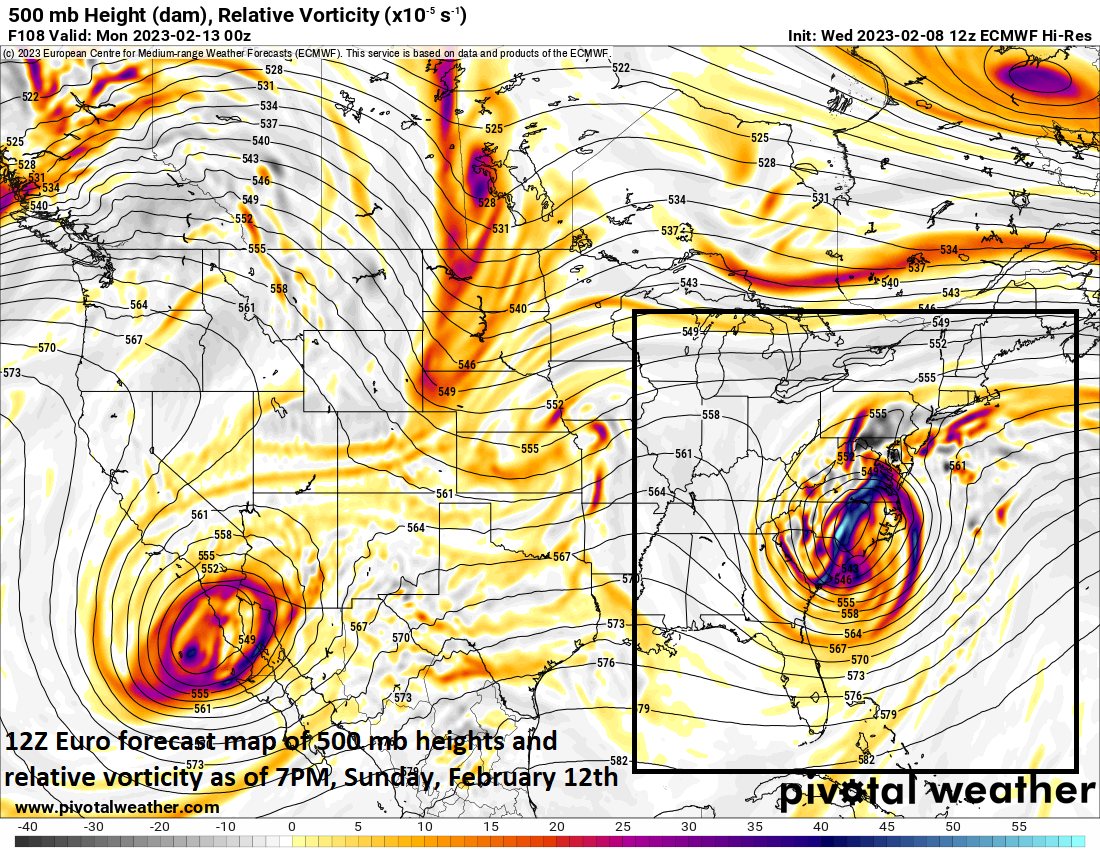
A vigorous upper-level low will move to the southeastern states by early this weekend and help to spawn the formation of a strong surface low pressure system which can impact the Mid-Atlantic region on Super Bowl Sunday. Map courtesy ECMWF (12Z Euro), Pivotal Weather
Elevation, “dynamic cooling” and the weekend storm
A second low pressure system will develop on Saturday near the Southeast US coastline as a vigorous upper-level low and vorticity maximum dives into that part of the nation from its current location over western Canada. The upper-level feature will become a slow-mover and this will result in a slow-moving surface low pressure system that likely only grind its way to the northeast later this weekend. In fact, this low pressure system is likely to move only from around the coastline of Georgia on Saturday to the coastline of North Carolina on Sunday. With cold air lacking at the onset of this storm, precipitation in the form of rain is likely to break out on Saturday in the Carolinas and then in the southern Mid-Atlantic region by mid-day Sunday.

A strong surface low pressure system will likely form this weekend near the eastern seaboard and it can move far enough to the north to impact the Mid-Atlantic region on Super Bowl Sunday. Map courtesy ECMWF (12Z Euro), Pivotal Weather
Despite the lack of any real cold air for this time of year, there can ultimately be a changeover of plain rain to sleet and/or snow with this system in some areas during the second half of the weekend. Two important factors with respect to the potential for wintry precipitation will be elevation and the potential for “dynamic cooling” in the atmosphere.
In higher terrain locations of the Carolinas (e.g., western North Carolina) and the Mid-Atlantic region (e.g., western Virginia, eastern West Virginia), enough cold air can develop in the cold sector of the storm to result in a changeover from plain rain to sleet and/or snow from later Saturday into Sunday and accumulations of wet snow are on the table. “Dynamic cooling” is a process which occurs when you have a strengthening low pressure system that creates enough vertical motion or “lift” in the atmosphere to produce heavy precipitation. As air rises, it cools within the atmosphere and if there is enough lift in a column of air, it can induce enough cold air to cause a changeover of plain rain to wet snow or sleet. This type of atmospheric process is certainly on the table with this upcoming system in some other areas as rapid intensification is likely given the expected strength of the upper-level low moving overhead…something to monitor in coming days in order to try to determine specific regions for this type of cooling to take place.
Meteorologist Paul Dorian
Arcfield
arcfieldweather.com
Follow us on Facebook, Twitter, YouTube
Video discussion: