11:30 AM | ***Major storm to impact much of the nation next few days…significant snowfall, flooding rains, ice and a severe weather outbreak***
Paul Dorian

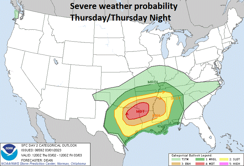
A severe weather outbreak is possible from later tomorrow into Friday across the Mississippi and Tennessee Valleys as strong low pressure will push from the south-central states towards the Great Lakes. Map courtesy NOAA/Storm Prediction Center
Overview
Strong low pressure now over the western US will impact much of the nation in coming days with significant snows, flooding rains, damaging ice, and even a severe weather outbreak. Heavy snow continues to fall today in the higher elevations of California’s Sierra Nevada Mountains and will intensify over the Rocky Mountains States from later today into Thursday. By later tomorrow, the strong surface low will slide into the south-central US and ingredients will likely come together for a severe weather outbreak across the Mississippi and Tennessee Valleys from late tomorrow into Friday. After that, this major storm system will push towards the Great Lakes on Friday, grind to a halt as it becomes influenced by intensifying high-latitude blocking and transfer its energy to a secondary low pressure system that will form off the northern Mid-Atlantic coastline. The result will be a significant snow event late in the week across parts of the Upper Midwest and Northeast US and ice can become a serious issue as well in some sections.
Details
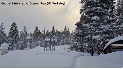
The snow has been intense during the past 24 hours across the Sierra Nevada Mountains of eastern California and given the fact that an active weather pattern is likely to continue into the month of April, this could actually turn out to be one of the snowiest winter seasons on record in that part of the Golden State. The Central Sierra Lab at Donner Pass (UC Berkeley) has received nearly 3 feet of snow in the past 24 hours, nearly 12 feet of snow in the past 7 days and more than 35 feet so far this year. Blizzard warnings will continue into late today in the Sierras with this latest powerful storm system that is adding substantially to an already extremely deep snowpack. Another storm can bring more snow to the region by late in the upcoming weekend.
This major storm system will next pound away at the Southwest US and Rocky Mountain States from later today into the day on Thursday. Not only will snowfall be heavy in some of the higher elevation locations (e.g., San Francisco Mountains of northern Arizona, Wasatch Mountains in Utah), the winds can be powerful as well as this low pressure system heads towards the middle of the country. Many of the national parks in the western states will get significant snowfall as well from this current storm system including Grand Canyon (AZ), Bryce Canyon and Zion in Utah.

The ingredients will come together later tomorrow/tomorrow night for a potential severe weather outbreak in the Mississippi and Tennessee Valleys with warm, humid air flowing northward from the Gulf of Mexico. At the same time, high pressure over southeastern Canada will send cold, dry low-level air into the Northeast US setting the stage for accumulating snow and ice by week’s end. Map courtesy NOAA, tropicaltidbits.com
By late tomorrow, this storm system will intensify over the south-central US and ingredients will come together (e.g., low-level warm, humid air flow from the Gulf of Mexico) for a potential severe weather outbreak across the Mississippi and Tennessee Valleys. In addition, flooding rainfall may become an important issue as well in this part of the country and all the way to the Ohio Valley. On the cold side of the storm, significant snow accumulations are likely from late Thursday into Friday in the region extending across Illinois, Indiana and Michigan.

Significant snow can fall from late Friday into Saturday across the Northeast US and icing can become a big issue in some sections. Map courtesy NOAA, tropicaltidbits.com
As this storm system reaches the Great Lakes region on Friday, it’ll begin to feel the effects of intensifying high-latitude blocking over the northeastern part of Canada. As such, the primary (initial) low pressure system will grind to a halt and transfer its energy to a secondary low pressure system that is likely to form by later Friday night somewhere off the northern Mid-Atlantic coastline. In the Mid-Atlantic, this is likely to be primarily a rain event across much of PA, NJ and all areas to the south of the PA/MD border. In upstate PA and interior NW NJ, there certainly can be a period of ice and/or snow before an ultimate changeover to rain although some spots may feature a stubborn refusal of surface cold air – anchored by high pressure over SE Canada - to give up its ground (i.e., an extended period of icing). Farther north, from the PA/NY border region and north, this could turn out to be a significant snow event as low pressure intensifies on Friday night and Saturday off the northern Mid-Atlantic coastline along with strong high pressure likely maintaining its ground in southeastern Canada.
Meteorologist Paul Dorian
Arcfield
arcfieldweather.com
Follow us on Facebook, Twitter, YouTube
Video discussion: